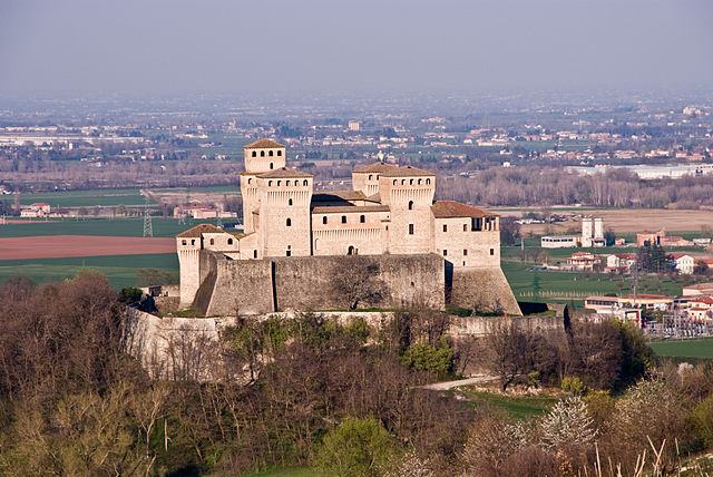
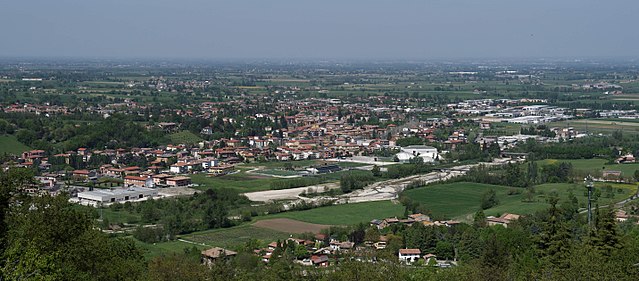
Невьяно-дельи-Ардуини (Neviano degli Arduini, Neviano degli Arduini)
.svg)
- коммуна Италии
 Hiking in Невьяно-дельи-Ардуини
Neviano degli Arduini is a charming village located in the province of Parma, within the Emilia-Romagna region of Italy. Nestled in the Apennine Mountains, it offers a variety of hiking opportunities that highlight the natural beauty of the area, including forests, rolling hills, and scenic views.
Hiking Trails
-
Sentiero dei Mulini: This trail is known for its historical significance, taking hikers past ancient watermills and through picturesque landscapes. It's a relatively easy hike, great for families and those looking for a more leisurely experience.
-
Loop Trails Around the Village: There are various loop trails that start and end in the village, allowing hikers to explore surrounding hills and valleys. These trails often provide stunning panoramic views of the Emilia-Romagna countryside.
-
Monte Fuso Trails: Just a short drive from Neviano, Monte Fuso offers a range of hiking options, including more challenging trails that lead to the summit, rewarding hikers with breathtaking vistas.
Things to Consider
-
Local Regulations: Always check for local hiking regulations and guidelines. Some areas may have restrictions or require permits, especially if you're venturing into protected natural parks.
-
Weather Conditions: Weather can change quickly in the mountains, so it’s important to check forecasts ahead of your hike and be prepared for varying conditions.
-
Equipment: Good hiking shoes, appropriate clothing layers, and a map or GPS device are essential. If you're planning on hiking in more remote areas, consider bringing trekking poles and a first aid kit.
Wildlife and Flora
The region is rich in biodiversity. As you hike, keep an eye out for local wildlife such as deer and various bird species. The flora is also diverse; look for wildflowers in the spring and summer.
Cultural Aspects
Don’t miss the opportunity to explore Neviano degli Arduini itself, with its quaint architecture and local cuisine. Take breaks in the village to enjoy traditional dishes and interact with the friendly locals, who can often provide tips on the best hiking spots.
Conclusion
Hiking in Neviano degli Arduini is a wonderful way to experience the natural beauty and cultural richness of the Emilia-Romagna region. Whether you are an experienced hiker or just starting out, there are trails suited for all levels, combined with the chance to enjoy local hospitality. Be sure to plan accordingly and embrace the tranquility that this beautiful area offers. Happy hiking!
- Страна:

- Почтовый код: 43024
- Телефонный код: 0521
- Код автомобильного номера: PR
- Координаты: 44° 35' 0" N, 10° 19' 0" E


- GPS треки (wikiloc): [Ссылка]
- Высота над уровнем моря: 517 м m
- Площадь: 105.96 кв.км
- Население: 3607
- Веб сайт: http://www.comune.neviano-degli-arduini.pr.it
- Википедия русская: wiki(ru)
- Википедия английская: wiki(en)
- Википедия национальная: wiki(it)
- Хранилище Wikidata: Wikidata: Q100850
- Катеория в википедии: [Ссылка]
- код Freebase: [/m/0gkdqt]
- код GeoNames: Альт: [6538426]
- код VIAF: Альт: [159163378]
- ID отношения в OpenStreetMap: [43224]
- код ISTAT: 034024
- кадастровый код Италии: F882
Граничит с регионами:

Лангирано
- коммуна Италии
Hiking in Лангирано
Langhirano is a beautiful area located in the province of Parma, in the Emilia-Romagna region of Italy. Known for its stunning landscapes, it offers various hiking opportunities that cater to different skill levels. Here’s a brief overview of what to expect when hiking in and around Langhirano:...
- Страна:
- Почтовый код: 43013
- Телефонный код: 0521
- Код автомобильного номера: PR
- Координаты: 44° 37' 0" N, 10° 16' 0" E
- GPS треки (wikiloc): [Ссылка]
- Высота над уровнем моря: 265 м m
- Площадь: 70.84 кв.км
- Население: 10346
- Веб сайт: [Ссылка]


Лезиньяно-де-Баньи
- коммуна Италии
Hiking in Лезиньяно-де-Баньи
Lesignano de' Bagni is a small municipality located in the province of Parma, in the Emilia-Romagna region of northern Italy. It is known for its beautiful landscapes, rolling hills, and natural hot springs, which are often associated with spa tourism....
- Страна:
- Почтовый код: 43037
- Телефонный код: 0521
- Код автомобильного номера: PR
- Координаты: 44° 38' 35" N, 10° 17' 58" E
- GPS треки (wikiloc): [Ссылка]
- Высота над уровнем моря: 252 м m
- Площадь: 47.49 кв.км
- Население: 5005
- Веб сайт: [Ссылка]
Паланцано
- коммуна Италии
Hiking in Паланцано
Palanzano is a charming village located in the Emilia-Romagna region of Italy, nestled in the Appennine Mountains. It's a wonderful destination for hikers, offering various trails that showcase the stunning natural beauty of the surrounding area. Here are some highlights and tips for hiking in Palanzano:...
- Страна:
- Почтовый код: 43025
- Телефонный код: 0521
- Код автомобильного номера: PR
- Координаты: 44° 26' 9" N, 10° 11' 35" E
- GPS треки (wikiloc): [Ссылка]
- Высота над уровнем моря: 691 м m
- Площадь: 69.8 кв.км
- Население: 1123
- Веб сайт: [Ссылка]


Тиццано-Валь-Парма
- коммуна Италии
Hiking in Тиццано-Валь-Парма
Tizzano Val Parma is a picturesque village located in the Emilia-Romagna region of Italy, nestled in the Apennine Mountains. It offers a variety of hiking opportunities amidst stunning natural landscapes, historic sites, and charming rural settings. Here are some highlights and tips for hiking in and around Tizzano Val Parma:...
- Страна:
- Почтовый код: 43028
- Телефонный код: 0521
- Код автомобильного номера: PR
- Координаты: 44° 31' 0" N, 10° 12' 0" E
- GPS треки (wikiloc): [Ссылка]
- Высота над уровнем моря: 800 м m
- Площадь: 78.39 кв.км
- Население: 2083
- Веб сайт: [Ссылка]

Траверсетоло
- коммуна Италии
Hiking in Траверсетоло
Traversetolo is a picturesque municipality located in the Emilia-Romagna region of Italy, surrounded by beautiful landscapes, rolling hills, and a rich variety of outdoor activities, including hiking. Although it may not be as well-known as some other Italian hiking destinations, it offers some delightful trails that allow you to experience the local flora, fauna, and stunning views of the surrounding countryside....
- Страна:
- Почтовый код: 43029
- Телефонный код: 0521
- Код автомобильного номера: PR
- Координаты: 44° 38' 24" N, 10° 22' 54" E
- GPS треки (wikiloc): [Ссылка]
- Высота над уровнем моря: 176 м m
- Площадь: 54.86 кв.км
- Население: 9474
- Веб сайт: [Ссылка]


Каносса
- коммуна Италии
Hiking in Каносса
Canossa, located in the Apennine Mountains of Italy, is a region steeped in history and natural beauty, making it a wonderful destination for hiking enthusiasts. Here are some key points about hiking in Canossa:...
- Страна:
- Почтовый код: 42026
- Телефонный код: 0522
- Код автомобильного номера: RE
- Координаты: 44° 34' 25" N, 10° 27' 19" E
- GPS треки (wikiloc): [Ссылка]
- Высота над уровнем моря: 219 м m
- Площадь: 53.08 кв.км
- Население: 3762
- Веб сайт: [Ссылка]
Ветто
- коммуна Италии
Hiking in Ветто
Vetto, a picturesque location in the Italian Apennines, offers a range of hiking opportunities for outdoor enthusiasts. Nestled in the Emilia-Romagna region, it is known for its stunning landscapes, including lush forests, rolling hills, and mountainous terrain....
- Страна:
- Почтовый код: 42020
- Телефонный код: 0522
- Код автомобильного номера: RE
- Координаты: 44° 29' 0" N, 10° 20' 0" E
- GPS треки (wikiloc): [Ссылка]
- Высота над уровнем моря: 447 м m
- Площадь: 53.37 кв.км
- Население: 1852
- Веб сайт: [Ссылка]