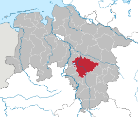
Нинбург (Nienburg/Weser, Landkreis Nienburg/Weser)

- район Германии (в земле Нижняя Саксония)
 Hiking in Нинбург
Nienburg (district) in Lower Saxony, Germany, offers a range of outdoor activities, including hiking, which can be enjoyed in its scenic landscapes. While the region isn't known for high mountains, it features beautiful rolling hills, tranquil rivers, and charming villages, making it an excellent area for hiking enthusiasts who appreciate more gentle terrains and lush nature.
Key Points for Hiking in Nienburg (District):
-
Landscape and Trails:
- The landscapes include the River Weser, meadows, and farmland, providing a peaceful setting for walkers.
- There are various marked trails, ranging from short strolls to longer hikes, suitable for different skill levels.
-
Local Nature Reserves and Parks:
- Nienburg’s Nature Reserves: The region has several nature reserves that offer trails where you can explore local flora and fauna.
- The Weser River Path: This long-distance hiking path follows the River Weser and offers picturesque views, quaint villages, and opportunities for resting.
-
Cultural and Historical Attractions:
- Along with the natural beauty, hikers can discover historical sites, such as old churches and traditional half-timbered houses in towns like Nienburg or nearby Stolzenau.
- Towns often celebrate local culture; integrating leisure with education about the region’s history.
-
Hiking Tips:
- Always check the weather before setting out, as conditions can change.
- Ensure you have adequate footwear and supplies, as some trails can be muddy or uneven.
- Carry a map or use a GPS app; while many trails are well-marked, it’s helpful to have a backup.
-
Local Facilities:
- Many rural areas have rest stops, cafes, or even farm shops where hikers can find refreshments and local delicacies.
- Accommodations can be found in nearby towns, ranging from hotels to camping sites for those who wish to extend their hiking adventures.
-
Best Times to Hike:
- Spring and early autumn are ideal for hiking in the Nienburg district, with pleasant temperatures and vibrant nature.
- Summer can also be lovely but can get quite warm, making early morning or late afternoon hikes more comfortable.
-
Community Events:
- Keep an eye on local events such as guided hikes or walking festivals which may occur throughout the year, providing a great way to explore the area with fellow hikers.
Whether you're looking for a leisurely walk through the countryside or a more ambitious hike along the Weser, Nienburg (district) has plenty to offer for hiking enthusiasts!
- Страна:

- Код автомобильного номера: NI
- Координаты: 52° 40' 12" N, 9° 10' 12" E


- GPS треки (wikiloc): [Ссылка]
- Высота над уровнем моря: 21 м m
- Площадь: 1399.00 кв.км
- Население: 121503
- Веб сайт: http://www.lk-nienburg.de/
- Википедия русская: wiki(ru)
- Википедия английская: wiki(en)
- Википедия национальная: wiki(de)
- Хранилище Wikidata: Wikidata: Q5958
- Катеория в википедии: [Ссылка]
- код Freebase: [/m/013xcz]
- код GeoNames: Альт: [2862622]
- код VIAF: Альт: [312830664]
- ID отношения в OpenStreetMap: [62728]
- код GND: Альт: [4042269-0]
- идентификатор местоположения ArchINFORM: [3977]
- код LCNAF: Альт: [n88116352]
- код TGN: [7128268]
- код NLI: [001019755]
- код NUTS: [DE927]
- код района Германии: 03256
Включает регионы:

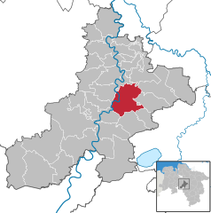
Нинбург
- город в Нижней Саксонии
Hiking in Нинбург
Nienburg, located in Lower Saxony, Germany, is a charming area offering various outdoor activities, including hiking. The region is characterized by picturesque landscapes, historical sites, and an abundance of nature....
- Страна:
- Почтовый код: 31582
- Телефонный код: 05021
- Код автомобильного номера: NI
- Координаты: 52° 38' 28" N, 9° 12' 25" E
- GPS треки (wikiloc): [Ссылка]
- Высота над уровнем моря: 25 м m
- Площадь: 64.45 кв.км
- Население: 31602
- Веб сайт: [Ссылка]
Граничит с регионами:


Зольтау-Фаллингбостель
Hiking in Зольтау-Фаллингбостель
Heidekreis, located in Lower Saxony, Germany, offers a variety of hiking opportunities amidst beautiful natural landscapes. The region is characterized by its mix of heathlands, forests, and moorlands, making it an attractive destination for outdoor enthusiasts....
- Страна:
- Столица: Бад-Фаллингбостель
- Код автомобильного номера: HK
- Координаты: 52° 55' 12" N, 9° 45' 0" E
- GPS треки (wikiloc): [Ссылка]
- Высота над уровнем моря: 64 м m
- Площадь: 1873.50 кв.км
- Население: 139641
- Веб сайт: [Ссылка]


Ферден
Hiking in Ферден
Verden, located in Lower Saxony, Germany, is an area that offers various outdoor activities, including hiking. The district is characterized by its lush landscapes, woodlands, and scenic countryside, making it a pleasant spot for nature lovers and hikers alike....
- Страна:
- Код автомобильного номера: VER
- Координаты: 53° 0' 0" N, 9° 10' 12" E
- GPS треки (wikiloc): [Ссылка]
- Высота над уровнем моря: 23 м m
- Площадь: 787.70 кв.км
- Население: 135842
- Веб сайт: [Ссылка]


Дипхольц
Hiking in Дипхольц
Diepholz is a district located in Lower Saxony, Germany, known for its scenic landscapes and outdoor recreational opportunities, including hiking. Here are some insights about hiking in and around Diepholz:...
- Страна:
- Код автомобильного номера: SY; DH
- Координаты: 52° 40' 12" N, 8° 34' 48" E
- GPS треки (wikiloc): [Ссылка]
- Высота над уровнем моря: 52 м m
- Площадь: 1987.00 кв.км
- Население: 209671
- Веб сайт: [Ссылка]

Ганновер
- район в Германии
Hiking in Ганновер
The Hanover Region, located in Lower Saxony, Germany, offers a variety of hiking opportunities for both beginners and experienced hikers alike. With its mix of natural landscapes, historical sites, and well-maintained trails, the region is a great destination for outdoor enthusiasts....
- Страна:
- Столица: Ганновер
- Код автомобильного номера: H
- Координаты: 52° 25' 12" N, 9° 43' 12" E
- GPS треки (wikiloc): [Ссылка]
- Высота над уровнем моря: 55 м m
- Площадь: 2291 кв.км
- Население: 1149594
- Веб сайт: [Ссылка]
Шаумбург
- район в земле Нижняя Саксония (Германия)
Hiking in Шаумбург
Schaumburg, located in northeastern Illinois, offers some enjoyable options for hiking, despite being a suburban area primarily known for its shopping and amenities. Here are a few notable spots you can explore:...
- Страна:
- Код автомобильного номера: SHG; RI
- Координаты: 52° 15' 0" N, 9° 10' 12" E
- GPS треки (wikiloc): [Ссылка]
- Высота над уровнем моря: 84 м m
- Площадь: 676.00 кв.км
- Население: 157616
- Веб сайт: [Ссылка]


Минден-Люббекке
Hiking in Минден-Люббекке
Minden-Lübbecke is a beautiful district in North Rhine-Westphalia, Germany, known for its picturesque landscapes, diverse flora and fauna, and numerous hiking opportunities. Here are some highlights and tips for hiking in the area:...
- Страна:
- Код автомобильного номера: MI
- Координаты: 52° 23' 57" N, 8° 43' 4" E
- GPS треки (wikiloc): [Ссылка]
- Высота над уровнем моря: 58 м m
- Площадь: 1051.97 кв.км
- Веб сайт: [Ссылка]