Обердорф (Oberdorf, Oberdorf NW)

- община в Швейцарии, Нидвальден
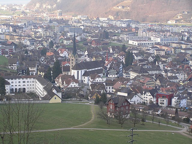
 Hiking in Обердорф
Oberdorf, located in the Nidwalden canton of Switzerland, offers a beautiful setting for hiking enthusiasts. Nestled in the central part of the country, this region is known for its stunning landscapes, including rolling hills, lush forests, and picturesque views of the surrounding mountains.
Hiking Highlights in Oberdorf, Nidwalden:
-
Scenic Trails: There are numerous well-marked hiking trails around Oberdorf that cater to all levels of hikers, from beginners to advanced. The trails often lead through charming villages, meadows, and along the banks of nearby rivers.
-
Panoramic Views: Hikes in this area frequently reward you with breathtaking panoramic views of the Swiss Alps and Lake Lucerne. Trails such as those leading to the nearby peaks provide excellent vantage points.
-
Nature and Wildlife: The region is rich in biodiversity, and you may encounter various wildlife and plant species unique to the Swiss landscape. Birdwatching and photography are popular activities during hikes here.
-
Local Culture: As you hike, you might pass through traditional Swiss villages where you can experience local culture, cuisine, and hospitality. Stopping at a local café or farm offers a great way to rest and recharge.
-
Accessibility: Oberdorf serves as a good starting point for longer hikes into the surrounding areas, including paths that lead to higher elevations or connecting trails towards nearby destinations like Aeschlen or Wolfenschiessen.
-
Seasonal Opportunities: In the summer, trails are in full bloom, while the winter offers opportunities for snowshoeing and winter hiking. Make sure to check trail conditions and accessibility depending on the season.
-
Safety and Preparedness: Always carry sufficient water, snacks, and a first-aid kit. Ensure you wear appropriate footwear and check the weather forecast before heading out, as conditions can change rapidly in the mountains.
-
Guided Tours: For those new to hiking or the area, consider joining a guided hike to learn more about the local ecology, history, and hidden gems of Oberdorf.
Whether you’re seeking a casual stroll or an adventurous trek, Oberdorf provides a wonderful backdrop for an enjoyable hiking experience. Always remember to respect nature and follow local regulations while exploring the beautiful Swiss landscapes!
- Страна:

- Почтовый код: 6370
- Телефонный код: 041
- Код автомобильного номера: NW
- Координаты: 46° 56' 33" N, 8° 24' 21" E


- GPS треки (wikiloc): [Ссылка]
- Высота над уровнем моря: 716 м m
- Площадь: 16.20 кв.км
- Население: 3133
- Веб сайт: http://www.oberdorf-nw.ch
- Википедия русская: wiki(ru)
- Википедия английская: wiki(en)
- Википедия национальная: wiki(de)
- Хранилище Wikidata: Wikidata: Q67154
- Катеория в википедии: [Ссылка]
Граничит с регионами:

Штанс
Hiking in Штанс
Hiking in Stans, a picturesque town in the Lucerne region of Switzerland, offers a variety of trails that cater to different skill levels and preferences. The stunning backdrop of the Swiss Alps provides a breathtaking experience, making it a popular destination for outdoor enthusiasts. Here are some key points to consider when hiking in Stans:...
- Страна:
- Почтовый код: 6370
- Телефонный код: 041
- Код автомобильного номера: NW
- Координаты: 46° 57' 34" N, 8° 22' 0" E
- GPS треки (wikiloc): [Ссылка]
- Высота над уровнем моря: 452 м m
- Площадь: 11.08 кв.км
- Население: 8411
- Веб сайт: [Ссылка]


Вольфеншиссен
Hiking in Вольфеншиссен
Wolfenschiessen is a charming village located in the Nidwalden region of Switzerland, nestled between the well-known mountains of the area. It's an excellent base for hiking enthusiasts due to its stunning natural scenery, well-marked trails, and access to the surrounding alpine landscapes....
- Страна:
- Почтовый код: 6386
- Телефонный код: 041
- Код автомобильного номера: NW
- Координаты: 46° 51' 46" N, 8° 23' 40" E
- GPS треки (wikiloc): [Ссылка]
- Высота над уровнем моря: 1516 м m
- Площадь: 92.76 кв.км
- Население: 2093
- Веб сайт: [Ссылка]


Буокс
Hiking in Буокс
Buochs is a charming municipality located in the canton of Nidwalden in Switzerland, nestled at the northern end of Lake Lucerne. The area offers stunning natural beauty and a variety of hiking opportunities suitable for different skill levels. Here are some highlights and tips for hiking in and around Buochs:...
- Страна:
- Почтовый код: 6374
- Телефонный код: 041
- Код автомобильного номера: NW
- Координаты: 46° 58' 29" N, 8° 25' 14" E
- GPS треки (wikiloc): [Ссылка]
- Высота над уровнем моря: 436 м m
- Площадь: 12.04 кв.км
- Население: 5409
- Веб сайт: [Ссылка]


Далленвиль
Hiking in Далленвиль
Dallenwil, a charming village located in the canton of Nidwalden, Switzerland, is surrounded by stunning natural landscapes that offer a variety of hiking opportunities. The area is known for its picturesque trails that cater to different skill levels, making it an attractive destination for both beginner and experienced hikers....
- Страна:
- Почтовый код: 6383
- Телефонный код: 041
- Код автомобильного номера: NW
- Координаты: 46° 55' 3" N, 8° 21' 54" E
- GPS треки (wikiloc): [Ссылка]
- Высота над уровнем моря: 1072 м m
- Площадь: 15.48 кв.км
- Население: 1814
- Веб сайт: [Ссылка]


Беккенрид
Hiking in Беккенрид
Beckenried, located in the canton of Nidwalden, Switzerland, is a beautiful destination for hiking enthusiasts. Nestled between Lake Lucerne and the surrounding mountains, it offers a variety of trails with stunning views, diverse landscapes, and the opportunity to explore the natural beauty of the region....
- Страна:
- Почтовый код: 6375
- Телефонный код: 041
- Код автомобильного номера: NW
- Координаты: 46° 57' 59" N, 8° 28' 29" E
- GPS треки (wikiloc): [Ссылка]
- Высота над уровнем моря: 448 м m
- Площадь: 32.95 кв.км
- Население: 3654
- Веб сайт: [Ссылка]