
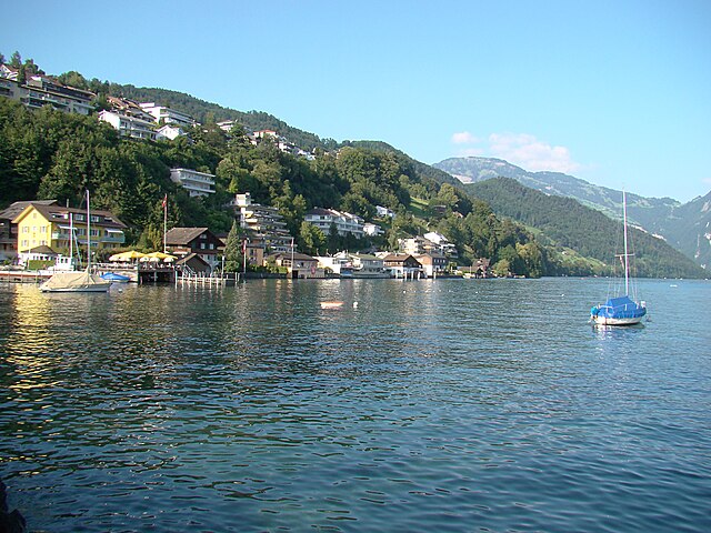
Штанс (Stans, Stans)

 Hiking in Штанс
Hiking in Stans, a picturesque town in the Lucerne region of Switzerland, offers a variety of trails that cater to different skill levels and preferences. The stunning backdrop of the Swiss Alps provides a breathtaking experience, making it a popular destination for outdoor enthusiasts. Here are some key points to consider when hiking in Stans:
Trails and Routes
- Niederbauen Mountain: A popular destination, accessible via a cable car, offers various trails with panoramic views. The hike to the summit is exhilarating and rewarding.
- Stanserhorn: This mountain can be reached by a combination of cable car and hiking. The trails offer different levels of difficulty and showcase beautiful views over Lake Lucerne and the surrounding mountains.
- Wanderweg Stans: There are marked walking paths that explore the picturesque countryside around Stans, perfect for leisurely hikes with scenic views.
Difficulty Levels
- Easy: Generally flat or gently rolling terrain, suitable for families and beginners.
- Moderate: More challenging, with some elevation gain and uneven terrain, ideal for those with some hiking experience.
- Difficult: Steep, rugged routes requiring good physical fitness and hiking experience.
Best Time to Hike
- Spring and Summer (May to October): Ideal for hiking, with most trails accessible and pleasant weather.
- Fall (September to November): Beautiful autumn colors; however, some trails may be less maintained.
- Winter (December to March): Some trails may be closed due to snow, but winter hiking and snowshoeing can be enjoyable in maintained areas.
Preparation and Safety
- Gear: Wear comfortable, weather-appropriate clothing and sturdy hiking boots. Always carry extra layers, a first aid kit, food, and water.
- Navigation: Familiarize yourself with maps or use a GPS device. The trails are generally well-marked; however, it's always good to have a backup.
- Weather: Check the forecast before heading out, as weather can change rapidly in the mountains.
Local Amenities
- Transportation: Stans is accessible by train and public transport, making it convenient to reach various trailheads.
- Facilities: Many trails have access to restaurants or mountain huts where you can enjoy traditional Swiss cuisine and refreshments.
Guided Hikes
If you’re not familiar with the area or prefer a guided experience, consider joining a local hiking tour. Guides can provide insights into the flora, fauna, and geology of the region, enhancing your experience.
Exploring the trails around Stans offers a fantastic way to experience the natural beauty of Switzerland. Enjoy your hiking adventure!
- Страна:

- Почтовый код: 6370
- Телефонный код: 041
- Код автомобильного номера: NW
- Координаты: 46° 57' 34" N, 8° 22' 0" E


- GPS треки (wikiloc): [Ссылка]
- Высота над уровнем моря: 452 м m
- Площадь: 11.08 кв.км
- Население: 8411
- Веб сайт: http://www.stans.ch
- Википедия русская: wiki(ru)
- Википедия английская: wiki(en)
- Википедия национальная: wiki(de)
- Хранилище Wikidata: Wikidata: Q63931
- Катеория в википедии: [Ссылка]
- код Freebase: [/m/01snsb]
- код GeoNames: Альт: [2658504]
- код VIAF: Альт: [158314334]
- ID отношения в OpenStreetMap: [1683112]
- код GND: Альт: [4056942-1]
- идентификатор местоположения ArchINFORM: [5378]
- код LCNAF: Альт: [n83136756]
- место в MusicBrainz: [3ab2ab8c-2807-43b0-82ed-4ec30591a789]
- код в энциклопедии «Британника онлайн»: [place/Stans]
- идентификатор HDS: [755]
- код швейцарского муниципалитета: [1509]
Граничит с регионами:


Штанстад
Hiking in Штанстад
Stansstad, located in the canton of Nidwalden in Switzerland, offers a variety of stunning hiking opportunities. Nestled between Lake Lucerne and the surrounding mountains, it's an ideal destination for both casual walkers and experienced hikers....
- Страна:
- Почтовый код: 6362
- Телефонный код: 041
- Код автомобильного номера: NW
- Координаты: 46° 58' 49" N, 8° 20' 20" E
- GPS треки (wikiloc): [Ссылка]
- Высота над уровнем моря: 436 м m
- Площадь: 17.11 кв.км
- Население: 4494
- Веб сайт: [Ссылка]

Эннетбюрген
Hiking in Эннетбюрген
Ennetbürgen is a picturesque village located near Lake Lucerne in the canton of Nidwalden, Switzerland. It offers a variety of hiking opportunities that immerse you in breathtaking natural landscapes, including stunning lake views and mountainous terrain. Here are some highlights and tips for hiking in and around Ennetbürgen:...
- Страна:
- Почтовый код: 6373
- Телефонный код: 041
- Код автомобильного номера: NW
- Координаты: 46° 59' 4" N, 8° 24' 50" E
- GPS треки (wikiloc): [Ссылка]
- Высота над уровнем моря: 435 м m
- Площадь: 17.70 кв.км
- Население: 4698
- Веб сайт: [Ссылка]


Буокс
Hiking in Буокс
Buochs is a charming municipality located in the canton of Nidwalden in Switzerland, nestled at the northern end of Lake Lucerne. The area offers stunning natural beauty and a variety of hiking opportunities suitable for different skill levels. Here are some highlights and tips for hiking in and around Buochs:...
- Страна:
- Почтовый код: 6374
- Телефонный код: 041
- Код автомобильного номера: NW
- Координаты: 46° 58' 29" N, 8° 25' 14" E
- GPS треки (wikiloc): [Ссылка]
- Высота над уровнем моря: 436 м m
- Площадь: 12.04 кв.км
- Население: 5409
- Веб сайт: [Ссылка]


Далленвиль
Hiking in Далленвиль
Dallenwil, a charming village located in the canton of Nidwalden, Switzerland, is surrounded by stunning natural landscapes that offer a variety of hiking opportunities. The area is known for its picturesque trails that cater to different skill levels, making it an attractive destination for both beginner and experienced hikers....
- Страна:
- Почтовый код: 6383
- Телефонный код: 041
- Код автомобильного номера: NW
- Координаты: 46° 55' 3" N, 8° 21' 54" E
- GPS треки (wikiloc): [Ссылка]
- Высота над уровнем моря: 1072 м m
- Площадь: 15.48 кв.км
- Население: 1814
- Веб сайт: [Ссылка]


Эннетмос
Hiking in Эннетмос
Ennetmoos is a charming village located near Lake Lucerne in Switzerland's scenic region. It is an excellent destination for hiking enthusiasts, offering a variety of trails that cater to different skill levels and preferences. Here are some highlights for hiking in Ennetmoos:...
- Страна:
- Почтовый код: 6372
- Телефонный код: 041
- Код автомобильного номера: NW
- Координаты: 46° 57' 24" N, 8° 20' 14" E
- GPS треки (wikiloc): [Ссылка]
- Высота над уровнем моря: 521 м m
- Площадь: 14.95 кв.км
- Население: 2147
- Веб сайт: [Ссылка]


Обердорф
- община в Швейцарии, Нидвальден
Hiking in Обердорф
Oberdorf, located in the Nidwalden canton of Switzerland, offers a beautiful setting for hiking enthusiasts. Nestled in the central part of the country, this region is known for its stunning landscapes, including rolling hills, lush forests, and picturesque views of the surrounding mountains....
- Страна:
- Почтовый код: 6370
- Телефонный код: 041
- Код автомобильного номера: NW
- Координаты: 46° 56' 33" N, 8° 24' 21" E
- GPS треки (wikiloc): [Ссылка]
- Высота над уровнем моря: 716 м m
- Площадь: 16.20 кв.км
- Население: 3133
- Веб сайт: [Ссылка]