Обертраун (Obertraun, Obertraun)
 Hiking in Обертраун
Obertraun, located in Austria's Salzkammergut region near the shores of Lake Hallstatt, is surrounded by stunning scenery and offers a variety of hiking options for all skill levels. The area is characterized by picturesque mountains, lush green valleys, and clear lakes, making it an ideal destination for hikers and nature enthusiasts.
Popular Hiking Trails in Obertraun:
-
Krippenstein Summit:
- This hike takes you to the summit of the Krippenstein mountain (2,109 meters). There are well-marked trails leading to different viewpoints. The hike provides stunning panoramic views of the Dachstein massif and the surrounding region. The trail can be challenging and is best suited for experienced hikers. You can also take the cable car partway up for an easier option.
-
Five Fingers Viewpoint:
- Starting from the Krippenstein cable car station, this relatively easy hike leads to the Five Fingers viewpoint. The viewpoint has platforms that extend over the edge of the cliff, offering breathtaking views of the Dachstein glacier, the surrounding mountains, and Lake Hallstatt. The walk is suitable for families and is well signposted.
-
Salt Trail (Salzweg):
- This historical trail follows the ancient salt mining routes. It offers a more educational experience as hikers can learn about the region's salt production history. The trail has sections that pass through beautiful forests and scenic vistas.
-
Lake Circuit:
- For a more relaxed option, consider hiking around Lake Obertraun or Lake Hallstatt. The trails around these lakes are generally easy and provide captivating views of the water and surrounding mountains. They are perfect for families or less experienced hikers.
Hiking Tips:
- Weather: Always check the weather conditions before heading out, as mountain weather can change rapidly.
- Equipment: Wear sturdy hiking boots and consider bringing trekking poles for added support. A good backpack with water, snacks, and a first-aid kit is essential.
- Maps and Navigation: Although trails are generally well-marked, carrying a trail map or using a hiking app can help with navigation.
- Respect Nature: Follow the principles of Leave No Trace, and be mindful of local wildlife and plant life.
Best Time to Hike:
The ideal hiking season in Obertraun lasts from late spring to early autumn (May to October), when the weather is generally warm and the trails are clear of snow. The fall foliage in September and October can also provide breathtaking scenery.
Overall, Obertraun is a wonderful hiking destination that blends natural beauty with outdoor adventure. Whether you're a serious mountaineer or just looking to enjoy a leisurely stroll with stunning views, Obertraun has something to offer for everyone.
- Страна:

- Почтовый код: 4831
- Телефонный код: 06131
- Код автомобильного номера: GM
- Координаты: 47° 33' 31" N, 13° 41' 1" E


- GPS треки (wikiloc): [Ссылка]
- Высота над уровнем моря: 513 м m
- Площадь: 34 кв.км
- Население: 738
- Веб сайт: http://www.obertraun.ooe.gv.at/
- Википедия русская: wiki(ru)
- Википедия английская: wiki(en)
- Википедия национальная: wiki(de)
- Хранилище Wikidata: Wikidata: Q612212
- Катеория в википедии: [Ссылка]
- код Freebase: [/m/02z9c0b]
- код GeoNames: Альт: [2769655]
- код VIAF: Альт: [124476687]
- код GND: Альт: [4527239-6]
- идентификатор местоположения ArchINFORM: [15963]
- код LCNAF: Альт: [n92025006]
- код австрийского муниципалитета: [40712]
Граничит с регионами:
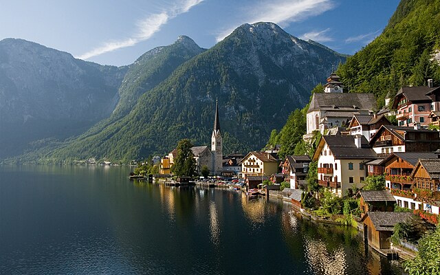
Гальштат
Hiking in Гальштат
Hallstatt, located in Austria's Salzkammergut region, is renowned for its stunning scenery, charming village atmosphere, and rich history, making it a fantastic hiking destination. Here are some highlights and recommendations for hiking in Hallstatt:...
- Страна:
- Почтовый код: 4830
- Телефонный код: 06134
- Код автомобильного номера: GM
- Координаты: 47° 33' 21" N, 13° 38' 48" E
- GPS треки (wikiloc): [Ссылка]
- Высота над уровнем моря: 511 м m
- Площадь: 59.8 кв.км
- Население: 778
- Веб сайт: [Ссылка]
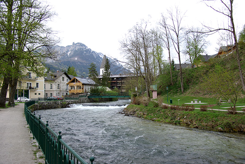
Бад-Аусзе
Hiking in Бад-Аусзе
Bad Aussee is a picturesque town located in the Salzkammergut region of Austria, renowned for its stunning mountain landscapes, crystal-clear lakes, and rich cultural heritage. It offers a variety of hiking opportunities suitable for different skill levels. Here are some highlights for hiking in Bad Aussee:...
- Страна:
- Почтовый код: 8990
- Телефонный код: 03622
- Координаты: 47° 36' 36" N, 13° 46' 58" E
- GPS треки (wikiloc): [Ссылка]
- Высота над уровнем моря: 659 м m
- Площадь: 82.03 кв.км
- Население: 4833
- Веб сайт: [Ссылка]
Бад-Гойзерн
- коммуна в Федеральной земле Верхняя Австрия
Hiking in Бад-Гойзерн
Bad Goisern am Hallstättersee is a picturesque village located in Upper Austria, near the stunning Hallstättersee (Lake Hallstatt). It is an excellent starting point for a variety of hiking trails that showcase the region's natural beauty, including mountains, lakes, and lush forests. Here are some highlights and useful information about hiking in the area:...
- Страна:
- Почтовый код: 4822
- Телефонный код: 06135
- Код автомобильного номера: GM
- Координаты: 47° 38' 30" N, 13° 37' 0" E
- GPS треки (wikiloc): [Ссылка]
- Высота над уровнем моря: 500 м m
- Площадь: 112.5 кв.км
- Население: 7450
- Веб сайт: [Ссылка]
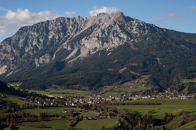
Рамзау-ам-Дахштайн
Hiking in Рамзау-ам-Дахштайн
Ramsau am Dachstein is a beautiful destination for hiking enthusiasts, located in the Austrian Alps. It's situated at the foot of the Dachstein massif and is known for its stunning landscapes, diverse trails, and picturesque alpine village atmosphere. Here are some highlights about hiking in Ramsau am Dachstein:...
- Страна:
- Почтовый код: 8972
- Телефонный код: 03687
- Код автомобильного номера: GB
- Координаты: 47° 25' 17" N, 13° 39' 17" E
- GPS треки (wikiloc): [Ссылка]
- Высота над уровнем моря: 1135 м m
- Площадь: 75.4 кв.км
- Население: 2766
- Веб сайт: [Ссылка]
Хаус
Hiking in Хаус
Haus im Ennstal is a charming village located in the Ennstal valley in Styria, Austria, and it serves as an excellent base for hikers looking to explore the beautiful surrounding landscape. The region is part of the larger Dachstein-Tauern area, known for its stunning alpine scenery, diverse trails, and outdoor activities....
- Страна:
- Почтовый код: 8967
- Телефонный код: 03686
- Код автомобильного номера: GB
- Координаты: 47° 24' 27" N, 13° 46' 1" E
- GPS треки (wikiloc): [Ссылка]
- Высота над уровнем моря: 774 м m
- Площадь: 81.77 кв.км
- Население: 2429
- Веб сайт: [Ссылка]
Грёбминг
Hiking in Грёбминг
Gröbming is a picturesque village located in the Ennstal region of Styria, Austria, and it serves as an excellent base for hiking enthusiasts. The area is surrounded by stunning alpine landscapes, making it a popular destination for both casual walkers and experienced hikers. Here’s what you need to know about hiking in Gröbming:...
- Страна:
- Почтовый код: 8962
- Телефонный код: 03685
- Код автомобильного номера: GB
- Координаты: 47° 26' 44" N, 13° 54' 4" E
- GPS треки (wikiloc): [Ссылка]
- Высота над уровнем моря: 770 м m
- Площадь: 66.94 кв.км
- Население: 3013
- Веб сайт: [Ссылка]