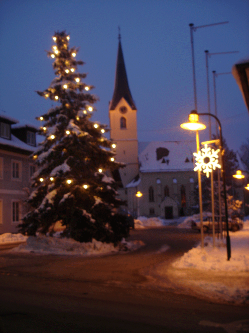
Ольсдорф (Ohlsdorf, Ohlsdorf)
 Hiking in Ольсдорф
Ohlsdorf, located in Hamburg, Germany, is well-known for its beautiful natural landscapes and well-maintained parks. While it may not be a traditional hiking destination like some mountainous areas, there are still lovely walking and hiking opportunities in and around Ohlsdorf, particularly in the Ohlsdorf Cemetery and nearby parks.
Ohlsdorf Cemetery
- Unique Setting: The Ohlsdorf Cemetery is one of the largest park cemeteries in the world. It features extensive pathways, beautiful trees, and serene ponds, making it a unique place for walking and light hiking.
- Trails: You can explore various paths that wind through the gardens and memorials. The peaceful environment allows for a reflective and enjoyable walking experience.
Parks Nearby
- Landschaftspark Ohlsdorf: This park features open meadows, wooded areas, and several walking paths that you can explore. It’s a great spot for a leisurely hike.
- Other Nearby Parks: Consider visiting the Alsterpark or the Hamm lake area if you’re looking to expand your hiking experience beyond Ohlsdorf. These areas also offer picturesque settings and established trails.
Tips for Hiking in Ohlsdorf
- Best Times to Visit: Early morning or late afternoon can be ideal for avoiding crowds and enjoying a more serene atmosphere.
- Comfortable Footwear: Wear sturdy shoes, as some paths may be uneven or require a bit of walking on gravel.
- Stay Hydrated: Bring water, especially if you plan on walking for an extended period.
- Respect Nature: Keep the area clean and respect the rules of the properties you visit, especially in sacred areas like the cemetery.
Getting There
Ohlsdorf is easily accessible via public transport, including the Hamburg U-Bahn (subway) and local buses. This makes it convenient for a day trip if you're in the Hamburg area.
Conclusion
While Ohlsdorf may not offer mountainous terrain, its parks and historical sites provide a unique backdrop for a pleasant hiking experience. Enjoy the tranquil environment and take in the beauty of this part of Hamburg!
- Страна:

- Почтовый код: 4694
- Телефонный код: 07612
- Код автомобильного номера: GM
- Координаты: 47° 57' 41" N, 13° 47' 34" E


- GPS треки (wikiloc): [Ссылка]
- Высота над уровнем моря: 538 м m
- Площадь: 27.9 кв.км
- Население: 5209
- Веб сайт: http://www.ohlsdorf.at/
- Википедия русская: wiki(ru)
- Википедия английская: wiki(en)
- Википедия национальная: wiki(de)
- Хранилище Wikidata: Wikidata: Q669162
- Катеория в википедии: [Ссылка]
- код Freebase: [/m/03gv4t2]
- код GeoNames: Альт: [7872015]
- код австрийского муниципалитета: [40713]
Граничит с регионами:
Пинсдорф
Hiking in Пинсдорф
Pinsdorf, located near the Traunsee lake in Austria, offers a variety of scenic hiking opportunities that cater to different skill levels. The region is characterized by its beautiful alpine landscapes, lush forests, and stunning views of the lake and surrounding mountains....
- Страна:
- Почтовый код: 4812
- Телефонный код: 07612
- Код автомобильного номера: GM
- Координаты: 47° 55' 49" N, 13° 46' 1" E
- GPS треки (wikiloc): [Ссылка]
- Высота над уровнем моря: 493 м m
- Площадь: 12.5 кв.км
- Население: 3849
- Веб сайт: [Ссылка]
Лакирхен
Hiking in Лакирхен
Laakirchen, located in Austria, is a charming and picturesque town near the foothills of the Alps, making it a great spot for hiking enthusiasts. The surrounding region offers a variety of trails that cater to different skill levels, from gentle walks suitable for families to more challenging hikes for experienced trekkers....
- Страна:
- Почтовый код: 4663
- Телефонный код: 07613
- Код автомобильного номера: GM
- Координаты: 47° 58' 58" N, 13° 49' 27" E
- GPS треки (wikiloc): [Ссылка]
- Высота над уровнем моря: 441 м m
- Площадь: 32.5 кв.км
- Население: 9861
- Веб сайт: [Ссылка]
Регау
Hiking in Регау
Regau, located in Upper Austria, offers a range of beautiful hiking opportunities for nature enthusiasts. The region is characterized by rolling hills, lush forests, and scenic views of the surrounding countryside. Here are some key points to consider when hiking in Regau:...
- Страна:
- Почтовый код: 4844
- Телефонный код: 07672
- Код автомобильного номера: VB
- Координаты: 47° 59' 31" N, 13° 41' 17" E
- GPS треки (wikiloc): [Ссылка]
- Высота над уровнем моря: 429 м m
- Площадь: 34 кв.км
- Население: 6780
- Веб сайт: [Ссылка]

Дессельбрун
Hiking in Дессельбрун
Desselbrunn is a charming area located in Upper Austria, known for its picturesque landscapes and nature trails, making it a great destination for hiking enthusiasts. Here are some key points to consider if you’re planning a hiking trip in Desselbrunn:...
- Страна:
- Почтовый код: 4693
- Телефонный код: 07673
- Код автомобильного номера: VB
- Координаты: 48° 1' 22" N, 13° 46' 25" E
- GPS треки (wikiloc): [Ссылка]
- Высота над уровнем моря: 421 м m
- Площадь: 17 кв.км
- Население: 1857
- Веб сайт: [Ссылка]
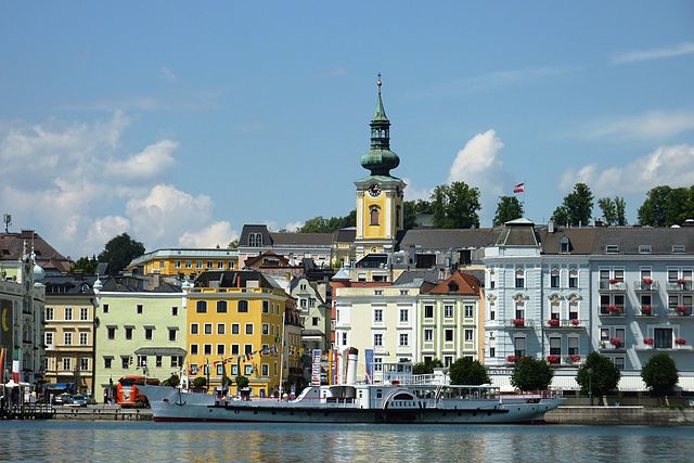
Гмунден
- город в Верхней Австрии
Hiking in Гмунден
Gmunden, located in Austria's Salzkammergut region, is a beautiful destination for hiking enthusiasts. The area is known for its stunning landscapes, characterized by alpine scenery, picturesque lakes, and charming villages. Here are some highlights and tips for hiking in Gmunden:...
- Страна:
- Почтовый код: 4810
- Телефонный код: 07612
- Код автомобильного номера: GM
- Координаты: 47° 55' 5" N, 13° 47' 58" E
- GPS треки (wikiloc): [Ссылка]
- Высота над уровнем моря: 425 м m
- Площадь: 63.49 кв.км
- Население: 13191
- Веб сайт: [Ссылка]

Гшвандт
Hiking in Гшвандт
Gschwandt is a charming village located in the Salzkammergut region of Austria, surrounded by beautiful landscapes, mountains, and lakes. It's a fantastic destination for hiking enthusiasts of all levels. Here are some key highlights and tips for hiking in the Gschwandt area:...
- Страна:
- Почтовый код: 4816
- Телефонный код: 07612
- Код автомобильного номера: GM
- Координаты: 47° 56' 6" N, 13° 50' 44" E
- GPS треки (wikiloc): [Ссылка]
- Высота над уровнем моря: 523 м m
- Площадь: 16.78 кв.км
- Население: 2750
- Веб сайт: [Ссылка]