Onglières (Onglières)

- коммуна во Франции
 Hiking in Onglières
Onglières is a picturesque area in France known for its scenic landscapes and hiking opportunities. While it might be less known than some larger national parks or tourist destinations, it offers a unique experience for hiking enthusiasts.
Hiking in Onglières
Terrain and Trails: The region features a mix of terrains, including gentle slopes, rocky paths, and forested areas, making it suitable for hikers of varying skill levels. Trails can vary in difficulty, ranging from easy, family-friendly walks to more challenging hikes for seasoned adventurers.
Nature and Scenery: Hikers can enjoy beautiful vistas, lush forests, and perhaps even views of local wildlife. The changing seasons add to the appeal, with vibrant colors in autumn and blooming flora in spring.
Local Attractions: In addition to beautiful trails, Onglières may have historical sites, viewpoints, and unique geological features that enhance your hiking experience. It's worth taking time to explore these aspects during your visit.
Tips for Hiking in Onglières
-
Prepare Accordingly: Always check trail conditions and weather forecasts before heading out. Dress in layers and bring weather-appropriate gear.
-
Stay Hydrated: Carry enough water, especially on longer hikes, and snacks to keep your energy up.
-
Navigational Tools: Use a map or a GPS application to navigate the trails. Some trails may not be well marked, so it's important to have a good sense of direction.
-
Respect Nature: Follow Leave No Trace principles to minimize your impact on the environment. Stay on marked trails and dispose of waste properly.
-
Safety First: Inform someone of your hiking plans, especially if you’re going on a solo hike. Carry a small first aid kit and know basic safety procedures.
-
Leave Room for Exploration: Take your time to enjoy the scenery and local wildlife. Sometimes the best experiences come from unplanned moments during hikes.
Before you go, it's a good idea to research specific trails in the Onglières area or consult local hiking guides for detailed information on the best routes, current conditions, and any safety advice. Enjoy your hike!
- Страна:

- Почтовый код: 39250
- Координаты: 46° 47' 43" N, 6° 0' 39" E


- GPS треки (wikiloc): [Ссылка]
- Площадь: 8.99 кв.км
- Население: 67
- Википедия английская: wiki(en)
- Википедия национальная: wiki(fr)
- Хранилище Wikidata: Wikidata: Q838915
- Катеория в википедии: [Ссылка]
- код Freebase: [/m/03nq0wk]
- код GeoNames: Альт: [6433676]
- номер SIREN: [213903933]
- код муниципалитета INSEE: 39393
Граничит с регионами:


Doye
Hiking in Doye
Doye is not widely recognized as a specific hiking destination in popular resources or hiking guides. It's possible that you may be referring to a lesser-known area or a local name for a specific region....
- Страна:
- Почтовый код: 39250
- Координаты: 46° 46' 0" N, 6° 0' 59" E
- GPS треки (wikiloc): [Ссылка]
- Площадь: 3.56 кв.км
- Население: 105

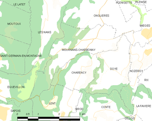
Mournans-Charbonny
- коммуна во Франции
Hiking in Mournans-Charbonny
Mournans-Charbonny is a picturesque commune located in the Jura region of France, which is known for its stunning landscapes, rolling hills, and rich flora and fauna. The area is an excellent choice for hiking enthusiasts, offering a range of trails that cater to various skill levels....
- Страна:
- Почтовый код: 39250
- Координаты: 46° 46' 48" N, 6° 0' 15" E
- GPS треки (wikiloc): [Ссылка]
- Высота над уровнем моря: 780 м m
- Площадь: 5.06 кв.км
- Население: 96


Chapois
- коммуна во Франции
Hiking in Chapois
Hiking in Chapois, located in the Jura region of France, offers a unique and breathtaking experience. The Jura mountains are known for their picturesque landscapes, rich biodiversity, and diverse trails suitable for various skill levels. Here are some key points to know about hiking in Chapois:...
- Страна:
- Почтовый код: 39300
- Координаты: 46° 50' 12" N, 5° 57' 40" E
- GPS треки (wikiloc): [Ссылка]
- Площадь: 10.07 кв.км
- Население: 219


Les Nans
- коммуна во Франции
Hiking in Les Nans
Les Nans, a picturesque area located in the French region of Provence-Alpes-Côte d'Azur, offers a variety of hiking opportunities that highlight its stunning natural beauty, rugged landscapes, and vibrant alpine flora. Here’s what you can expect when hiking in this region:...
- Страна:
- Почтовый код: 39300
- Координаты: 46° 47' 27" N, 5° 58' 28" E
- GPS треки (wikiloc): [Ссылка]
- Площадь: 8.05 кв.км
- Население: 86


Plénisette
- коммуна во Франции
Hiking in Plénisette
Plénisette is a charming location situated in the French Alps, known for its stunning landscapes and a variety of hiking opportunities. While it might not be as widely recognized as some higher-profile hiking destinations, it offers beautiful trails suitable for both novice and experienced hikers. Here are some key points to consider when hiking in and around Plénisette:...
- Страна:
- Почтовый код: 39250
- Координаты: 46° 47' 58" N, 6° 1' 16" E
- GPS треки (wikiloc): [Ссылка]
- Площадь: 2.61 кв.км
- Население: 24


Mièges
- коммуна во Франции
Hiking in Mièges
Mièges is a charming village located in the Jura department of France, surrounded by beautiful natural landscapes that are perfect for hiking enthusiasts. The area features rolling hills, dense forests, and panoramic views, making it a great destination for outdoor activities....
- Страна:
- Почтовый код: 39250
- Координаты: 46° 46' 57" N, 6° 2' 13" E
- GPS треки (wikiloc): [Ссылка]
- Площадь: 3.19 кв.км
- Население: 99

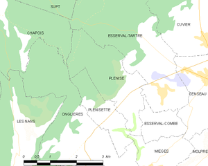
Plénise
- коммуна во Франции
Hiking in Plénise
Plénise, a picturesque region, offers a variety of hiking opportunities for outdoor enthusiasts. While specific trails and information might vary, here's a general guide to hiking in this charming area:...
- Страна:
- Почтовый код: 39250
- Координаты: 46° 48' 23" N, 6° 1' 46" E
- GPS треки (wikiloc): [Ссылка]
- Площадь: 5.43 кв.км
- Население: 62