Оттенсхайм (Ottensheim, Ottensheim)
 Hiking in Оттенсхайм
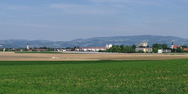
Ottensheim is a charming town located in Upper Austria, situated on the banks of the Danube River, just a short distance from Linz. The region around Ottensheim offers a variety of hiking opportunities for both novice and experienced hikers, with scenic views, lush landscapes, and a mix of terrain.
Here are some highlights for hiking in and around Ottensheim:
Hiking Trails
-
Donausteig Trail: This long-distance trail runs along the Danube River and passes near Ottensheim. It features well-marked paths with varying levels of difficulty, showcasing beautiful riverside views, vineyards, and rural landscapes.
-
Mühlviertel Region: Just north of Ottensheim, the Mühlviertel region offers numerous trails that take you through forests, pastures, and hills, perfect for those looking to explore nature more deeply.
-
Donauradweg (Danube Cycle Path): While primarily a cycling route, many parts of the Donauradweg are also suitable for hikers. It provides a flat, scenic route along the river, making it accessible for families.
-
Local Trails: Look for local way-marked trails that may take you to nearby hills and viewpoints, such as the Pöstlingberg near Linz, which offers panoramic views of the area.
Accessibility
Ottensheim is easily accessible from Linz via public transportation, making it a convenient starting point for hikers. The town itself has several amenities, including restaurants and shops, where you can stock up on supplies or enjoy a meal after your hike.
Safety Tips
- Dress Appropriately: Weather can change quickly in this region, so wearing layers and having waterproof gear is advisable.
- Stay Hydrated: Carry enough water, especially for longer hikes.
- Navigation: While trails are generally well-marked, it’s a good idea to carry a map or use a hiking app for navigation.
- Time Management: Plan your hikes according to your fitness level and make sure to complete your hike before dark.
Conclusion
Hiking in and around Ottensheim offers a unique blend of natural beauty and cultural experiences. Whether you're looking for a leisurely riverside stroll or a more challenging trek in the hills, this area has something for everyone. Enjoy your adventure!
- Страна:

- Почтовый код: 4100
- Телефонный код: 07234
- Код автомобильного номера: UU
- Координаты: 48° 20' 0" N, 14° 10' 37" E


- GPS треки (wikiloc): [Ссылка]
- Высота над уровнем моря: 270 м m
- Площадь: 11.81 кв.км
- Население: 4721
- Веб сайт: http://www.ottensheim.ooe.gv.at/
- Википедия русская: wiki(ru)
- Википедия английская: wiki(en)
- Википедия национальная: wiki(de)
- Хранилище Wikidata: Wikidata: Q683160
- Катеория в википедии: [Ссылка]
- код Freebase: [/m/03gvcyd]
- код GeoNames: Альт: [7873242]
- код VIAF: Альт: [131507881]
- код GND: Альт: [4314303-9]
- идентификатор местоположения ArchINFORM: [10719]
- код LCNAF: Альт: [n95023368]
- место в MusicBrainz: [113154e5-819b-44ed-95ec-96432448905c]
- WOEID: [546304]
- код австрийского муниципалитета: [41617]
Граничит с регионами:
Алькофен
Hiking in Алькофен
Alkoven is a picturesque town located in the Upper Austria region, near Linz. The area around Alkoven offers a range of hiking opportunities, surrounded by beautiful landscapes, forests, and hills that are perfect for both beginner and experienced hikers....
- Страна:
- Почтовый код: 4072
- Телефонный код: 07274
- Код автомобильного номера: EF
- Координаты: 48° 17' 14" N, 14° 6' 25" E
- GPS треки (wikiloc): [Ссылка]
- Высота над уровнем моря: 268 м m
- Площадь: 42.58 кв.км
- Население: 5961
- Веб сайт: [Ссылка]

Вальдинг
Hiking in Вальдинг
Walding, a charming municipality in Austria, offers a variety of hiking opportunities for outdoor enthusiasts. Nestled in the picturesque landscape of Upper Austria, Walding is known for its beautiful scenery, rolling hills, and lush greenery....
- Страна:
- Почтовый код: 4111
- Телефонный код: 07234
- Код автомобильного номера: UU
- Координаты: 48° 21' 1" N, 14° 9' 44" E
- GPS треки (wikiloc): [Ссылка]
- Высота над уровнем моря: 303 м m
- Площадь: 15.32 кв.км
- Население: 4095
- Веб сайт: [Ссылка]


Грамаштеттен
Hiking in Грамаштеттен
Gramastetten is a charming town located in Austria, near the city of Linz. The region is known for its scenic landscapes, rolling hills, and lush forests, making it a great destination for hiking enthusiasts....
- Страна:
- Телефонный код: 0 72 39
- Код автомобильного номера: UU
- Координаты: 48° 22' 52" N, 14° 11' 24" E
- GPS треки (wikiloc): [Ссылка]
- Высота над уровнем моря: 545 м m
- Площадь: 40.2 кв.км
- Население: 5102
- Веб сайт: [Ссылка]
Гольдвёрт
Hiking in Гольдвёрт
Goldwörth, a charming municipality in Austria's Upper Austria region, offers a range of scenic hiking opportunities for both beginners and experienced hikers. The surrounding landscape is characterized by rolling hills, lush forests, and picturesque countryside, making it an appealing destination for outdoor enthusiasts....
- Страна:
- Почтовый код: 4102
- Телефонный код: 0 72 34
- Код автомобильного номера: UU
- Координаты: 48° 20' 39" N, 14° 6' 0" E
- GPS треки (wikiloc): [Ссылка]
- Высота над уровнем моря: 262 м m
- Площадь: 11 кв.км
- Население: 840
- Веб сайт: [Ссылка]

Пухенау
Hiking in Пухенау
Puchenau, located in Austria near the city of Linz, offers a charming environment for hiking enthusiasts. The region is characterized by beautiful landscapes, rolling hills, and scenic views, especially along the banks of the Danube River....
- Страна:
- Код автомобильного номера: UU
- Координаты: 48° 18' 39" N, 14° 14' 29" E
- GPS треки (wikiloc): [Ссылка]
- Высота над уровнем моря: 265 м m
- Площадь: 8.19 кв.км
- Население: 4445
- Веб сайт: [Ссылка]

Вильхеринг
Hiking in Вильхеринг
Wilhering is a picturesque area located in Austria, near the city of Linz, and offers a range of hiking opportunities that combine natural beauty with cultural experiences. Here are some highlights for hiking in and around Wilhering:...
- Страна:
- Почтовый код: 4073
- Код автомобильного номера: LL
- Координаты: 48° 19' 26" N, 14° 11' 26" E
- GPS треки (wikiloc): [Ссылка]
- Высота над уровнем моря: 270 м m
- Площадь: 30 кв.км
- Население: 5911
- Веб сайт: [Ссылка]