Oye-et-Pallet (Oye-et-Pallet)

- коммуна во Франции
 Hiking in Oye-et-Pallet
Oye-et-Pallet is a small commune in the Hauts-de-France region of France, located in the Nord department. While it may not be a widely recognized hiking destination, the surrounding areas offer opportunities for outdoor activities and exploring the natural beauty of the region.
Hiking Opportunities:
-
Local Trails: While Oye-et-Pallet itself may not have extensive dedicated hiking trails, you can find paths and routes in the surrounding countryside and nearby villages. Walking through the picturesque landscapes can provide a charming hiking experience.
-
Nearby Nature Reserves: Explore nearby nature reserves or parks. The wider Nord region has various natural sites where you can find established trails suitable for hiking.
-
Regional Parks: Consider visiting the Parc Naturel Régional des Caps et Marais d'Opale, which offers scenic trails through a diverse range of landscapes, including coastal paths, marshlands, and woodlands. It's a bit of a drive from Oye-et-Pallet but worth it for a full day of hiking.
Considerations:
- Difficulty Levels: Ensure to check the difficulty level of any trails you plan to hike. The trails can vary from easy walks to more strenuous hikes.
- Weather: The weather in northern France can be quite variable, so it’s essential to check the forecast before heading out. Be prepared for rain and varying temperatures.
- Navigation: If you’re unfamiliar with the area, consider bringing a map or GPS device to help navigate. Some trails may not be well-marked.
Recommendations:
- Equipment: Wear sturdy hiking shoes and dress in layers for comfort. Bringing a small backpack with water, snacks, and a basic first-aid kit is always a good idea.
- Safety: Always inform someone about your hiking plans and estimated return time, especially if hiking alone.
While Oye-et-Pallet may not be a major hiking hub, it can serve as a cozy base to explore the natural beauty of northern France. Happy hiking!
- Страна:

- Почтовый код: 25160
- Координаты: 46° 51' 12" N, 6° 20' 3" E


- GPS треки (wikiloc): [Ссылка]
- Площадь: 10.45 кв.км
- Население: 726
- Википедия английская: wiki(en)
- Википедия национальная: wiki(fr)
- Хранилище Wikidata: Wikidata: Q909486
- Катеория в википедии: [Ссылка]
- код Freebase: [/m/03mgc2q]
- код Freebase: [/m/03mgc2q]
- код GeoNames: Альт: [6429930]
- код GeoNames: Альт: [6429930]
- номер SIREN: [212504427]
- номер SIREN: [212504427]
- код BNF: [152526680]
- код BNF: [152526680]
- код муниципалитета INSEE: 25442
- код муниципалитета INSEE: 25442
Граничит с регионами:


Ла-Клюз-э-Мижу
- коммуна во Франции
Hiking in Ла-Клюз-э-Мижу
La Cluse-et-Mijoux is a picturesque commune located in the Doubs department of the Bourgogne-Franche-Comté region in eastern France. Nestled in the Jura mountains, it offers beautiful landscapes, lush forests, and scenic views, making it a great destination for hiking enthusiasts....
- Страна:
- Почтовый код: 25300
- Координаты: 46° 52' 19" N, 6° 22' 43" E
- GPS треки (wikiloc): [Ссылка]
- Площадь: 22.5 кв.км
- Население: 1318
- Веб сайт: [Ссылка]

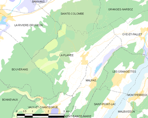
La Planée
- коммуна во Франции
Hiking in La Planée
Hiking in La Planée, located in the French Alps, offers stunning landscapes and diverse trails suitable for different skill levels. The area is known for its picturesque views, ranging from sweeping valleys to rugged mountain peaks....
- Страна:
- Почтовый код: 25160
- Координаты: 46° 50' 25" N, 6° 16' 55" E
- GPS треки (wikiloc): [Ссылка]
- Площадь: 13 кв.км
- Население: 261


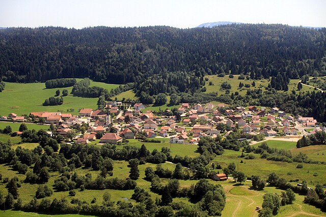
Монперрё
- коммуна во Франции
Hiking in Монперрё
Montperreux is a picturesque destination located near Lake Neuchâtel in Switzerland. It offers stunning views and a variety of hiking trails that cater to different skill levels. Here are some key points to consider when hiking in Montperreux:...
- Страна:
- Почтовый код: 25160
- Координаты: 46° 49' 33" N, 6° 20' 31" E
- GPS треки (wikiloc): [Ссылка]
- Площадь: 11.61 кв.км
- Население: 837


Malpas
- коммуна во Франции
Hiking in Malpas
Malpas, located in the Doubs department of France, is a picturesque area known for its natural beauty and outdoor activities, including hiking. The Doubs region is characterized by its varied landscapes, including rolling hills, dense forests, and the winding Doubs River. Here are some key points to consider when hiking in Malpas and its surroundings:...
- Страна:
- Почтовый код: 25160
- Координаты: 46° 49' 35" N, 6° 17' 22" E
- GPS треки (wikiloc): [Ссылка]
- Площадь: 5.78 кв.км
- Население: 273

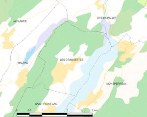
Les Grangettes
- коммуна во Франции
Hiking in Les Grangettes
Les Grangettes is a beautiful hiking destination located in the French Alps, close to the town of Échirolles and the larger city of Grenoble. The area is known for its stunning natural scenery, characterized by lush meadows, alpine forests, and breathtaking mountain views....
- Страна:
- Почтовый код: 25160
- Координаты: 46° 49' 40" N, 6° 18' 40" E
- GPS треки (wikiloc): [Ссылка]
- Площадь: 5.38 кв.км
- Население: 276

Granges-Narboz
- коммуна во Франции
Hiking in Granges-Narboz
Granges-Narboz, located in the Jura mountains of France, offers various hiking opportunities for nature enthusiasts and outdoor adventurers. This picturesque area is characterized by rolling hills, dense forests, and stunning views of the surrounding landscapes, making it a great spot for hiking....
- Страна:
- Почтовый код: 25300
- Координаты: 46° 52' 45" N, 6° 18' 38" E
- GPS треки (wikiloc): [Ссылка]
- Площадь: 16.22 кв.км
- Население: 1170
- Веб сайт: [Ссылка]