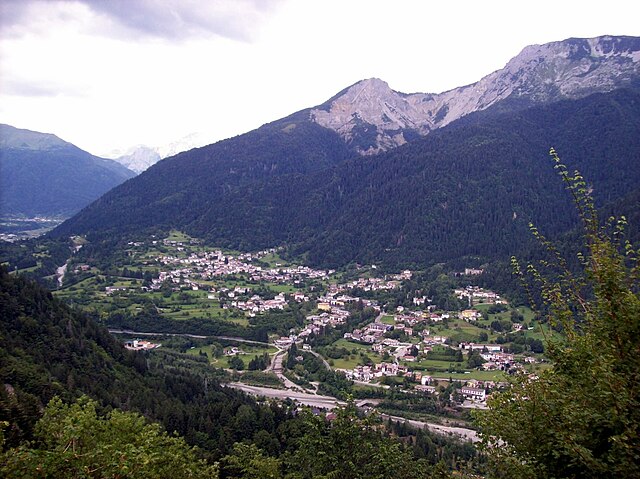
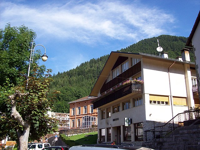
Палуцца (Paluzza, Paluzza)
.svg)
- коммуна Италии
 Hiking in Палуцца
Paluzza is a charming town situated in the Friuli Venezia Giulia region of northeastern Italy, surrounded by the stunning features of the Carnic Alps. Hiking in Paluzza offers a wide variety of trails suitable for different skill levels, making it a great destination for both beginners and experienced hikers.
Key Hiking Areas
-
Carnic Alps: The Carnic Alps, where Paluzza is located, provide numerous hiking opportunities with breathtaking views, diverse landscapes, and rich biodiversity. You can find trails that range from easy walks to challenging mountain hikes.
-
Monte Coglians: The highest peak in the Carnic Alps, Monte Coglians offers excellent hiking routes. The trail to the summit often provides panoramic views and is suitable for more experienced hikers.
-
Glemtal Valley: This beautiful valley features several trails, including routes that lead to picturesque mountain huts. It's a great place for family hikes and those looking to enjoy idyllic scenery without strenuous climbs.
-
Alpe del Cason: If you're up for a more remote hike, the trails around Alpe del Cason offer a more peaceful experience with fewer crowds. These paths are often surrounded by nature, making them ideal for birdwatching and enjoying the scenery.
Seasonality
The best time for hiking in Paluzza is typically late spring through early autumn (May to October). During these months, the weather is generally mild, and the trails are usually clear of snow. However, the summer can get busy, so it's advisable to start hikes early in the day.
Preparation and Tips
- Gear: Ensure you have appropriate hiking boots, clothing, and supplies (water, snacks, first-aid kit). A map or GPS device is recommended for navigation.
- Weather: Be aware that mountain weather can change rapidly. Always check the forecast before heading out and be prepared for sudden weather changes, especially if you're hiking at higher elevations.
- Respect Nature: Stay on marked trails to protect local flora and fauna, and follow Leave No Trace principles to preserve the area’s natural beauty.
Local Amenities
Paluzza has local accommodations, including hotels and guesthouses, and there are restaurants where you can enjoy traditional Friulian cuisine after a day of hiking. Consider trying local specialties such as frico (cheese and potato dish) or polenta.
Overall, hiking in Paluzza is a wonderful experience, combining stunning natural landscapes with a chance to connect with the local culture and traditions of the region. Whether you're looking for a leisurely stroll or an adventurous trek, you'll find plenty of options to explore!
- Страна:

- Почтовый код: 33026
- Телефонный код: 0433
- Код автомобильного номера: UD
- Координаты: 46° 32' 0" N, 13° 1' 0" E


- GPS треки (wikiloc): [Ссылка]
- Высота над уровнем моря: 605 м m
- Площадь: 69.75 кв.км
- Население: 2158
- Веб сайт: http://www.comune.paluzza.ud.it
- Википедия русская: wiki(ru)
- Википедия английская: wiki(en)
- Википедия национальная: wiki(it)
- Хранилище Wikidata: Wikidata: Q53303
- Катеория в википедии: [Ссылка]
- код Freebase: [/m/0gk9jg]
- код GeoNames: Альт: [6536313]
- код VIAF: Альт: [240134349]
- ID отношения в OpenStreetMap: [79193]
- код ISTAT: 030071
- кадастровый код Италии: G300
Граничит с регионами:

Арта-Терме
- коммуна Италии
Hiking in Арта-Терме
Arta Terme, located in the Friuli Venezia Giulia region of northeastern Italy, is a beautiful destination for hiking enthusiasts. This picturesque area is surrounded by the Carnic Alps and offers a range of trails suitable for all levels, from beginners to experienced hikers....
- Страна:
- Почтовый код: 33022
- Телефонный код: 0433
- Код автомобильного номера: UD
- Координаты: 46° 29' 0" N, 13° 1' 0" E
- GPS треки (wikiloc): [Ссылка]
- Высота над уровнем моря: 422 м m
- Площадь: 42.77 кв.км
- Население: 2076
- Веб сайт: [Ссылка]
Черчивенто
- коммуна Италии
Hiking in Черчивенто
Cercivento is a picturesque village located in the Friuli Venezia Giulia region of northeastern Italy, surrounded by stunning landscapes that offer a variety of hiking opportunities. The area is characterized by its beautiful mountains, rolling hills, and rich biodiversity....
- Страна:
- Почтовый код: 33020
- Телефонный код: 0433
- Код автомобильного номера: UD
- Координаты: 46° 32' 0" N, 12° 59' 0" E
- GPS треки (wikiloc): [Ссылка]
- Высота над уровнем моря: 607 м m
- Площадь: 15.78 кв.км
- Население: 672
- Веб сайт: [Ссылка]


Комельянс
- коммуна Италии
Hiking in Комельянс
Comeglians is a charming village located in the Friuli Venezia Giulia region of northeastern Italy, nestled in the heart of the Carnic Alps. The area is ideal for hiking enthusiasts, offering a variety of trails that cater to different skill levels and preferences. Here’s a breakdown of what you can expect when hiking in Comeglians:...
- Страна:
- Почтовый код: 33023
- Телефонный код: 0433
- Код автомобильного номера: UD
- Координаты: 46° 31' 0" N, 12° 53' 0" E
- GPS треки (wikiloc): [Ссылка]
- Высота над уровнем моря: 553 м m
- Площадь: 19.41 кв.км
- Население: 491
- Веб сайт: [Ссылка]


Форни-Авольтри
- коммуна Италии
Hiking in Форни-Авольтри
Forni Avoltri is a charming village located in the Friuli Venezia Giulia region of northeastern Italy, surrounded by the stunning landscapes of the Carnic Alps. The area is well-known for its beautiful hiking trails, which cater to a variety of skill levels, from beginners to more experienced hikers....
- Страна:
- Почтовый код: 33020
- Телефонный код: 0433
- Код автомобильного номера: UD
- Координаты: 46° 35' 0" N, 12° 47' 0" E
- GPS треки (wikiloc): [Ссылка]
- Высота над уровнем моря: 888 м m
- Площадь: 80.75 кв.км
- Население: 562
- Веб сайт: [Ссылка]


Лигозулло
- коммуна Италии
Hiking in Лигозулло
Ligosullo is a picturesque area in the Friuli Venezia Giulia region of Italy, known for its scenic landscapes and great hiking opportunities. Nestled in the eastern Alps, the region offers a variety of trails that cater to different skill levels, making it an excellent destination for both casual walkers and experienced hikers....
- Страна:
- Почтовый код: 33020
- Телефонный код: 0433
- Код автомобильного номера: UD
- Координаты: 46° 32' 22" N, 13° 4' 27" E
- GPS треки (wikiloc): [Ссылка]
- Высота над уровнем моря: 948 м m
- Площадь: 16.85 кв.км
- Население: 104
- Веб сайт: [Ссылка]


Пауларо
- коммуна Италии
Hiking in Пауларо
Paularo, located in the Friuli Venezia Giulia region of northeastern Italy, is a charming destination for hikers and outdoor enthusiasts. Nestled within the beautiful backdrop of the Carnic Alps, it offers a variety of trails that cater to different skill levels, making it an attractive spot for both novice and seasoned hikers....
- Страна:
- Почтовый код: 33027
- Телефонный код: 0433
- Код автомобильного номера: UD
- Координаты: 46° 32' 0" N, 13° 7' 0" E
- GPS треки (wikiloc): [Ссылка]
- Высота над уровнем моря: 648 м m
- Площадь: 84.24 кв.км
- Население: 2556
- Веб сайт: [Ссылка]

Равасклетто
- коммуна Италии
Hiking in Равасклетто
Ravascletto, located in the Friuli Venezia Giulia region of Italy, is a beautiful destination for hiking enthusiasts. Nestled within the Carnic Alps, it offers a range of hiking trails that cater to various skill levels, making it an ideal spot for both beginners and experienced hikers....
- Страна:
- Почтовый код: 33020
- Телефонный код: 0433
- Код автомобильного номера: UD
- Координаты: 46° 32' 0" N, 12° 55' 0" E
- GPS треки (wikiloc): [Ссылка]
- Высота над уровнем моря: 952 м m
- Площадь: 26.48 кв.км
- Население: 530
- Веб сайт: [Ссылка]


Риголато
- коммуна Италии
Hiking in Риголато
Rigolato is a charming village located in the Friuli Venezia Giulia region of northeastern Italy. It sits in the heart of the Carnic Alps, making it a fantastic destination for hiking enthusiasts. Here are some highlights and tips for hiking in Rigolato:...
- Страна:
- Почтовый код: 33020
- Телефонный код: 0433
- Код автомобильного номера: UD
- Координаты: 46° 33' 0" N, 12° 51' 0" E
- GPS треки (wikiloc): [Ссылка]
- Высота над уровнем моря: 760 м m
- Площадь: 30.77 кв.км
- Население: 428
- Веб сайт: [Ссылка]


Сутрио
- коммуна Италии
Hiking in Сутрио
Sutrio is a charming village located in the Friuli Venezia Giulia region of northeastern Italy, and it's known for its stunning natural landscapes and rich cultural heritage. Hiking in this area can be a delightful experience, as it offers a variety of trails suitable for different skill levels....
- Страна:
- Почтовый код: 33020
- Телефонный код: 0433
- Код автомобильного номера: UD
- Координаты: 46° 30' 50" N, 12° 59' 25" E
- GPS треки (wikiloc): [Ссылка]
- Высота над уровнем моря: 565 м m
- Площадь: 20.75 кв.км
- Население: 1296
- Веб сайт: [Ссылка]

Кёчах-Маутен
- политическая община в Австрии
Hiking in Кёчах-Маутен
Kötschach-Mauthen, located in the picturesque area of Carinthia, Austria, offers a range of hiking opportunities that cater to all levels of experience, from easy walks to more challenging mountain hikes. The scenic landscapes include lush valleys, alpine meadows, and stunning mountain views that make it a delight for nature enthusiasts and hikers alike....
- Страна:

- Почтовый код: 9640
- Телефонный код: 04715
- Код автомобильного номера: HE
- Координаты: 46° 40' 0" N, 13° 0' 0" E
- GPS треки (wikiloc): [Ссылка]
- Высота над уровнем моря: 705 м m
- Площадь: 154.14 кв.км
- Население: 3348
- Веб сайт: [Ссылка]

Лезахталь
Hiking in Лезахталь
Lesachtal is a picturesque valley located in the Austrian Alps, primarily in Carinthia, and is known for its stunning natural landscapes, traditional villages, and a variety of hiking trails suited for different skill levels. Here’s what you can expect when hiking in Lesachtal:...
- Страна:
- Телефонный код: 04716
- Код автомобильного номера: HE
- Координаты: 46° 41' 38" N, 12° 48' 57" E
- GPS треки (wikiloc): [Ссылка]
- Высота над уровнем моря: 1043 м m
- Площадь: 190.69 кв.км
- Население: 1318
- Веб сайт: [Ссылка]