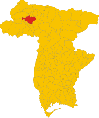
Комельянс (Comeglians, Comeglians)
.svg)
- коммуна Италии
 Hiking in Комельянс
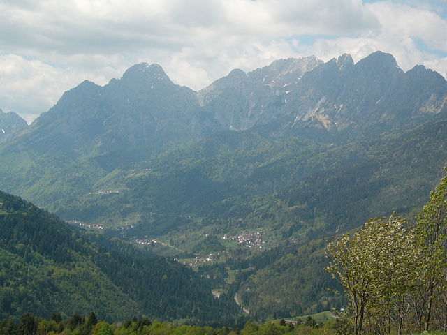
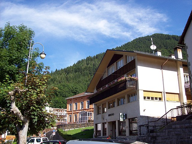
Comeglians is a charming village located in the Friuli Venezia Giulia region of northeastern Italy, nestled in the heart of the Carnic Alps. The area is ideal for hiking enthusiasts, offering a variety of trails that cater to different skill levels and preferences. Here’s a breakdown of what you can expect when hiking in Comeglians:
Scenic Trails
-
Nature Trails: The region boasts beautiful landscapes with lush forests, alpine meadows, and stunning mountain views. Look for trails that take you through the Val d'Arzino or along the riverbanks where the scenery is particularly picturesque.
-
Mountain Trekking: More experienced hikers can explore the higher elevations of the Carnic Alps, where you can find trails leading to breathtaking viewpoints such as Monte Cuar and Monte Peralba.
-
Historical Hikes: Some trails may take you to historical sites or remnants from World War I, as this area has a rich history tied to the conflict.
Trail Difficulty
The hiking trails around Comeglians vary in difficulty. Beginners can opt for easier paths that are well-marked and less strenuous, while experienced hikers may seek out challenging routes that require more preparation and skill, especially those that involve steep ascents or rocky terrain.
Best Time to Hike
The ideal time for hiking in Comeglians is typically from late spring to early autumn (May to September). During this period, the weather is usually mild and the trails are more accessible. Be sure to check local weather conditions before heading out, as mountain weather can change rapidly.
Essential Gear
- Footwear: Good hiking boots are a must for stability and comfort on rocky or uneven terrain.
- Clothing: Dress in layers to accommodate temperature changes. A waterproof jacket is recommended.
- Navigation Tools: A map and compass, or a GPS device, can be helpful, especially on less-marked trails.
- Safety Equipment: A first-aid kit, plenty of water, and snacks are essential for longer hikes.
Local Tips
- Guided Tours: If you're unfamiliar with the area, consider joining a guided hiking tour to get the most out of your experience.
- Wildlife Watching: Keep an eye out for local wildlife, including deer, marmots, and various bird species.
- Local Cuisine: After a long hike, indulge in local dishes at one of the village restaurants. Friulian cuisine is delicious and often features hearty meals perfect for refueling after a day outdoors.
Conclusion
Hiking in Comeglians offers a perfect blend of natural beauty, historical exploration, and serene landscapes. Whether you're looking for an easy stroll or a challenging ascent, the trails in and around this quaint village provide ample opportunities for outdoor adventures. Always prioritize safety, stay informed about the trails, and enjoy your hike!
- Страна:

- Почтовый код: 33023
- Телефонный код: 0433
- Код автомобильного номера: UD
- Координаты: 46° 31' 0" N, 12° 53' 0" E


- GPS треки (wikiloc): [Ссылка]
- Высота над уровнем моря: 553 м m
- Площадь: 19.41 кв.км
- Население: 491
- Веб сайт: http://www.comune.comeglians.ud.it
- Википедия русская: wiki(ru)
- Википедия английская: wiki(en)
- Википедия национальная: wiki(it)
- Хранилище Wikidata: Wikidata: Q53249
- Катеория в википедии: [Ссылка]
- код Freebase: [/m/0gk8q5]
- код GeoNames: Альт: [6536309]
- код VIAF: Альт: [130536862]
- ID отношения в OpenStreetMap: [79253]
- код ISTAT: 030029
- кадастровый код Италии: C918
Граничит с регионами:

Оваро
- коммуна Италии
Hiking in Оваро
Ovaro is a beautiful town located in the Friuli Venezia Giulia region of northeastern Italy. It's situated in the Carnic Alps and is surrounded by stunning natural landscapes, making it a great destination for hiking enthusiasts. Here are some key points to consider when hiking in and around Ovaro:...
- Страна:
- Почтовый код: 33025
- Телефонный код: 0433
- Код автомобильного номера: UD
- Координаты: 46° 29' 0" N, 12° 52' 0" E
- GPS треки (wikiloc): [Ссылка]
- Высота над уровнем моря: 525 м m
- Площадь: 57.9 кв.км
- Население: 1875
- Веб сайт: [Ссылка]


Палуцца
- коммуна Италии
Hiking in Палуцца
Paluzza is a charming town situated in the Friuli Venezia Giulia region of northeastern Italy, surrounded by the stunning features of the Carnic Alps. Hiking in Paluzza offers a wide variety of trails suitable for different skill levels, making it a great destination for both beginners and experienced hikers....
- Страна:
- Почтовый код: 33026
- Телефонный код: 0433
- Код автомобильного номера: UD
- Координаты: 46° 32' 0" N, 13° 1' 0" E
- GPS треки (wikiloc): [Ссылка]
- Высота над уровнем моря: 605 м m
- Площадь: 69.75 кв.км
- Население: 2158
- Веб сайт: [Ссылка]

Прато-Карнико
- коммуна Италии
Hiking in Прато-Карнико
Prato Carnico is a beautiful alpine village located in the Friuli Venezia Giulia region of northeastern Italy. It's set in the Carnic Alps, offering stunning natural landscapes that are perfect for hiking enthusiasts. Here are some highlights and tips for hiking in the Prato Carnico area:...
- Страна:
- Почтовый код: 33020
- Телефонный код: 0433
- Код автомобильного номера: UD
- Координаты: 46° 31' 0" N, 12° 49' 0" E
- GPS треки (wikiloc): [Ссылка]
- Высота над уровнем моря: 686 м m
- Площадь: 81.72 кв.км
- Население: 898
- Веб сайт: [Ссылка]

Равасклетто
- коммуна Италии
Hiking in Равасклетто
Ravascletto, located in the Friuli Venezia Giulia region of Italy, is a beautiful destination for hiking enthusiasts. Nestled within the Carnic Alps, it offers a range of hiking trails that cater to various skill levels, making it an ideal spot for both beginners and experienced hikers....
- Страна:
- Почтовый код: 33020
- Телефонный код: 0433
- Код автомобильного номера: UD
- Координаты: 46° 32' 0" N, 12° 55' 0" E
- GPS треки (wikiloc): [Ссылка]
- Высота над уровнем моря: 952 м m
- Площадь: 26.48 кв.км
- Население: 530
- Веб сайт: [Ссылка]


Риголато
- коммуна Италии
Hiking in Риголато
Rigolato is a charming village located in the Friuli Venezia Giulia region of northeastern Italy. It sits in the heart of the Carnic Alps, making it a fantastic destination for hiking enthusiasts. Here are some highlights and tips for hiking in Rigolato:...
- Страна:
- Почтовый код: 33020
- Телефонный код: 0433
- Код автомобильного номера: UD
- Координаты: 46° 33' 0" N, 12° 51' 0" E
- GPS треки (wikiloc): [Ссылка]
- Высота над уровнем моря: 760 м m
- Площадь: 30.77 кв.км
- Население: 428
- Веб сайт: [Ссылка]