
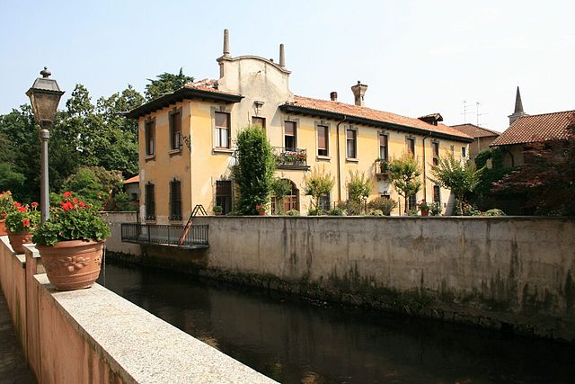
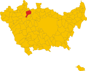
Парабьяго (Parabiago, Parabiago)
.svg)
- коммуна Италии
 Hiking in Парабьяго
Parabiago, a town in the Lombardy region of Italy, is surrounded by scenic landscapes that offer various opportunities for hiking and outdoor activities. While Parabiago itself is not a major hiking destination, it is well-positioned to access trails and natural areas in the nearby regions. Here are some insights about hiking in and around Parabiago:
Local Trails
-
Nature Reserves: Explore nearby nature reserves, such as the Parco dei Mulini, which features walking paths and the chance to see local flora and fauna.
-
Cerro di Vanzago: Not too far from Parabiago, this area has several trails that can be explored, providing a mix of easy walks and more challenging routes.
-
Local Parks: Parabiago and its surrounding areas have local parks suitable for leisurely walks, picnics, and getting acquainted with the local surroundings.
Nearby Hiking Areas
-
Parco della Valle del Lambro: This park is located farther away and features a variety of trails that wind through gorgeous landscapes along the Lambro River, which can be reached by car or public transport.
-
Prealpi and Val d’Intelvi: A bit further afield, but these areas are renowned for their stunning hiking paths, offering breathtaking views and more challenging hikes for experienced adventurers.
-
Monte Grigna: If you're willing to drive a bit more, Monte Grigna offers a range of hiking trails, from easy to very challenging, with magnificent views of the surrounding mountains and valleys.
Tips for Hiking in the Area
- Preparation: Always check the weather conditions beforehand and wear appropriate footwear.
- Hydration: Carry enough water and snacks, particularly on longer hikes.
- Maps: Use local hiking maps or apps to navigate trails effectively, as signage may vary.
- Wildlife: Be aware of local wildlife, and respect their habitats by staying on marked trails.
- Local Regulations: Follow local guidelines and regulations for hiking to protect the environment and ensure safety.
Conclusion
While Parabiago itself may not be a major hiking hub, its accessible location allows for easy explorations of various hiking trails, nature parks, and reserves in the surrounding Lombardy region. If you’re looking for hikes with stunning scenery and varying difficulty levels, you won’t be disappointed!
- Страна:

- Почтовый код: 20015
- Телефонный код: 0331
- Код автомобильного номера: MI
- Координаты: 45° 33' 30" N, 8° 56' 52" E


- GPS треки (wikiloc): [Ссылка]
- Высота над уровнем моря: 184 м m
- Площадь: 14.29 кв.км
- Население: 27747
- Веб сайт: http://www.comune.parabiago.mi.it/
- Википедия русская: wiki(ru)
- Википедия английская: wiki(en)
- Википедия национальная: wiki(it)
- Хранилище Wikidata: Wikidata: Q42629
- Катеория в википедии: [Ссылка]
- код Freebase: [/m/0cxkjr]
- код GeoNames: Альт: [6536518]
- код VIAF: Альт: [139641563]
- ID отношения в OpenStreetMap: [45241]
- код LCNAF: Альт: [n86132327]
- место в MusicBrainz: [e065377f-d053-46e3-a3d2-05a1497defdc]
- код темы Quora: [Parabiago]
- код TGN: [7005926]
- UN/LOCODE: [ITPRG]
- код в Большой каталанской энциклопедии: [0048930]
- код Trismegistos: [30833]
- код ISTAT: 015168
- кадастровый код Италии: G324
- LombardiaBeniCulturali toponym ID: 8000358
Граничит с регионами:
Нервьяно
- коммуна Италии
Hiking in Нервьяно
Nerviano is a charming town located in the Lombardy region of Italy, not far from Milan. While it might not be known as a traditional hiking destination, there are various areas nearby where hiking enthusiasts can enjoy some outdoor activities....
- Страна:
- Почтовый код: 20014
- Телефонный код: 0331
- Код автомобильного номера: MI
- Координаты: 45° 33' 0" N, 8° 59' 0" E
- GPS треки (wikiloc): [Ссылка]
- Высота над уровнем моря: 175 м m
- Площадь: 13.26 кв.км
- Население: 17270
- Веб сайт: [Ссылка]
Черро-Магжиоре
- коммуна Италии
Hiking in Черро-Магжиоре
Cerro Maggiore is a beautiful hiking destination located in the Lombardy region of Italy, near the town of the same name. This area is known for its scenic landscapes, diverse flora, and excellent trails that cater to various skill levels. Here are some key points to consider when planning a hike in Cerro Maggiore:...
- Страна:
- Почтовый код: 20023
- Телефонный код: 0331
- Код автомобильного номера: MI
- Координаты: 45° 36' 0" N, 8° 57' 0" E
- GPS треки (wikiloc): [Ссылка]
- Высота над уровнем моря: 205 м m
- Площадь: 10.12 кв.км
- Население: 15224
- Веб сайт: [Ссылка]

Бусто-Гарольфо
- коммуна Италии
Hiking in Бусто-Гарольфо
Busto Garolfo is a small town located in the Lombardy region of Italy, just northwest of Milan. While it may not be as widely known for hiking as larger national parks or mountainous areas, there are still several opportunities for outdoor activities in and around the region. Here are some key points about hiking in Busto Garolfo:...
- Страна:
- Почтовый код: 20020
- Телефонный код: 0331
- Код автомобильного номера: MI
- Координаты: 45° 32' 52" N, 8° 53' 12" E
- GPS треки (wikiloc): [Ссылка]
- Высота над уровнем моря: 180 м m
- Площадь: 12.99 кв.км
- Население: 13850
- Веб сайт: [Ссылка]
Казореццо
- коммуна Италии
Hiking in Казореццо
Casorezzo is a small town located in the Lombardy region of Italy, not far from larger cities like Milan. While it may not be a widely recognized hiking destination, there are still opportunities for walking and enjoying the outdoors in the surrounding areas....
- Страна:
- Почтовый код: 20010
- Телефонный код: 02
- Код автомобильного номера: MI
- Координаты: 45° 31' 0" N, 8° 54' 0" E
- GPS треки (wikiloc): [Ссылка]
- Высота над уровнем моря: 166 м m
- Площадь: 6.6 кв.км
- Население: 5467
- Веб сайт: [Ссылка]


Сан-Витторе-Олона
- коммуна Италии
Hiking in Сан-Витторе-Олона
San Vittore Olona is a charming town in the Lombardy region of Italy, situated not far from Milan. While it may not be a well-known hiking destination, it offers some lovely outdoor experiences and access to the surrounding areas....
- Страна:
- Почтовый код: 20028
- Телефонный код: 0331
- Код автомобильного номера: MI
- Координаты: 45° 35' 0" N, 8° 56' 0" E
- GPS треки (wikiloc): [Ссылка]
- Высота над уровнем моря: 197 м m
- Площадь: 3.49 кв.км
- Население: 8425
- Веб сайт: [Ссылка]


Арлуно
- коммуна Италии
Hiking in Арлуно
Arluno, situated in the Lombardy region of Italy, is not widely known as a hiking destination compared to some other areas in Italy. However, there are opportunities for nature walks and light hiking in and around the area, with the surrounding countryside offering some pleasant trails....
- Страна:
- Почтовый код: 20010
- Телефонный код: 02
- Код автомобильного номера: MI
- Координаты: 45° 30' 0" N, 8° 56' 0" E
- GPS треки (wikiloc): [Ссылка]
- Высота над уровнем моря: 156 м m
- Площадь: 12.36 кв.км
- Население: 11807
- Веб сайт: [Ссылка]


Канеграте
- коммуна Италии
Hiking in Канеграте
Canegrate is a town in the Lombardy region of Italy, located near Milan. While it may not be as well-known for hiking as some of the more mountainous areas in the region, there are still opportunities for outdoor activities and walking trails in and around Canegrate....
- Страна:
- Почтовый код: 20010
- Телефонный код: 0331
- Код автомобильного номера: MI
- Координаты: 45° 34' 0" N, 8° 56' 0" E
- GPS треки (wikiloc): [Ссылка]
- Высота над уровнем моря: 196 м m
- Площадь: 5.25 кв.км
- Население: 12574
- Веб сайт: [Ссылка]