Парцаника (Parzanica, Parzanica)
.svg)
- коммуна Италии
 Hiking in Парцаника
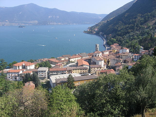
Parzanica is a small village located in Italy, within the province of Bergamo in the Lombardy region. It sits on the eastern shore of Lake Iseo, surrounded by beautiful natural landscapes, making it a lovely destination for hiking enthusiasts. Here are some highlights about hiking in Parzanica:
Scenic Trails
-
Panoramic Views: Many hiking trails around Parzanica offer stunning views of Lake Iseo and the surrounding mountains. The variety of elevations ensures that you can find both easy walks and more challenging hikes.
-
Local Trails: There are several well-marked trails that cater to different skill levels. You can hike through vineyards, olive groves, and forests, immersing yourself in the local flora and fauna.
-
Nearby Trails: The Sentiero dei Templari is a nearby trail that is popular among hikers, leading you through scenic spots that highlight the region’s history and natural beauty.
Hiking Tips
- Weather Awareness: The weather can change quickly in mountainous areas, so it's vital to check the forecast and be prepared for sudden changes, especially in spring or autumn.
- Footwear: Make sure to wear good hiking boots that provide support and traction, as some trails may be rocky or steep.
- Stay Hydrated: Carry enough water, especially during the summer months when temperatures can rise.
Wildlife and Nature
The area around Parzanica is rich in biodiversity. You might encounter various bird species and enjoy the local vegetation, including chestnut trees and Mediterranean plants.
Local Culture
Hiking in Parzanica also offers a taste of local culture. After your hike, consider visiting a local trattoria or café to enjoy traditional Lombard cuisine and perhaps some local wine.
Accessibility
Parzanica can be reached from larger towns in the region, and several access points to trails are easily found in and around the village.
Overall, hiking in Parzanica is an excellent way to experience the natural beauty, culture, and tranquility of this charming area of Northern Italy. Remember to respect nature, stick to marked trails, and leave no trace to preserve its beauty for future visitors. Enjoy your adventure!
- Страна:

- Почтовый код: 24060
- Телефонный код: 035
- Код автомобильного номера: BG
- Координаты: 45° 44' 0" N, 10° 2' 0" E


- GPS треки (wikiloc): [Ссылка]
- Высота над уровнем моря: 753 м m
- Площадь: 9.82 кв.км
- Население: 362
- Веб сайт: http://www.comune.parzanica.bg.it/
- Википедия русская: wiki(ru)
- Википедия английская: wiki(en)
- Википедия национальная: wiki(it)
- Хранилище Wikidata: Wikidata: Q101369
- Галерея изображений в википедии: [Ссылка]
- Катеория в википедии: [Ссылка]
- код Freebase: [/m/0gjcm5]
- код GeoNames: Альт: [6536147]
- ID отношения в OpenStreetMap: [45888]
- код TGN: [7053110]
- код ISTAT: 016159
- кадастровый код Италии: G350
Граничит с регионами:


Фонтено
- коммуна Италии
Hiking in Фонтено
Fonteno is a charming town located in the province of Bergamo in Italy, perched on the hills overlooking Lake Iseo. It offers a variety of hiking opportunities that cater to different skill levels and preferences. Here are some highlights and tips for hiking in the Fonteno area:...
- Страна:
- Почтовый код: 24060
- Телефонный код: 035
- Код автомобильного номера: BG
- Координаты: 45° 46' 0" N, 10° 1' 0" E
- GPS треки (wikiloc): [Ссылка]
- Высота над уровнем моря: 606 м m
- Площадь: 10.93 кв.км
- Население: 583
- Веб сайт: [Ссылка]


Рива-ди-Сольто
- коммуна Италии
Hiking in Рива-ди-Сольто
Riva di Solto is a beautiful village located on the shores of Lake Iseo in northern Italy. It offers stunning views, lush landscapes, and a variety of trails that cater to different skill levels. Here's what you should know about hiking in this area:...
- Страна:
- Почтовый код: 24060
- Телефонный код: 035
- Код автомобильного номера: BG
- Координаты: 45° 46' 0" N, 10° 2' 0" E
- GPS треки (wikiloc): [Ссылка]
- Высота над уровнем моря: 186 м m
- Площадь: 8.52 кв.км
- Население: 913
- Веб сайт: [Ссылка]
Тавернола-Бергамаска
- коммуна Италии
Hiking in Тавернола-Бергамаска
Tavernola Bergamasca is a picturesque town located in the Bergamo province of Italy, overlooking Lago d'Iseo (Lake Iseo), which is known for its stunning landscapes, charming villages, and numerous hiking trails. Here are some highlights for hiking in and around Tavernola Bergamasca:...
- Страна:
- Почтовый код: 24060
- Телефонный код: 035
- Код автомобильного номера: BG
- Координаты: 45° 43' 0" N, 10° 3' 0" E
- GPS треки (wikiloc): [Ссылка]
- Высота над уровнем моря: 191 м m
- Площадь: 11.17 кв.км
- Население: 2042
- Веб сайт: [Ссылка]


Виголо
- коммуна Италии
Hiking in Виголо
Vigolo is a picturesque region in northern Italy, often defined by its stunning natural landscapes and opportunities for outdoor activities, including hiking. While I don't have specific trails in Vigolo, I can provide some general insights into what you might expect when hiking in this area:...
- Страна:
- Почтовый код: 24060
- Телефонный код: 035
- Код автомобильного номера: BG
- Координаты: 45° 43' 0" N, 10° 1' 0" E
- GPS треки (wikiloc): [Ссылка]
- Высота над уровнем моря: 616 м m
- Площадь: 12.31 кв.км
- Население: 579
- Веб сайт: [Ссылка]

Мароне
- коммуна Италии
Hiking in Мароне
Marone is a picturesque town located on the eastern shore of Lake Iseo in Italy, and it is surrounded by beautiful mountainous terrain, making it a fantastic location for hiking enthusiasts. The area offers a range of trails suitable for different skill levels, from easy walks along the lake to more challenging hikes in the hills and mountains....
- Страна:
- Почтовый код: 25054
- Телефонный код: 030
- Код автомобильного номера: BS
- Координаты: 45° 44' 0" N, 10° 6' 0" E
- GPS треки (wikiloc): [Ссылка]
- Высота над уровнем моря: 189 м m
- Площадь: 23.93 кв.км
- Население: 3178
- Веб сайт: [Ссылка]

Монте-Изола
- коммуна Италии
Hiking in Монте-Изола
Monte Isola is a stunning destination for hiking enthusiasts, located in the middle of Lake Iseo in northern Italy. It is the largest lake island in Europe and offers a unique combination of beautiful landscapes, charming villages, and rich cultural heritage. Here are some key points to consider when planning your hiking adventure in Monte Isola:...
- Страна:
- Почтовый код: 25050
- Телефонный код: 030
- Код автомобильного номера: BS
- Координаты: 45° 43' 0" N, 10° 5' 0" E
- GPS треки (wikiloc): [Ссылка]
- Высота над уровнем моря: 275 м m
- Площадь: 12.61 кв.км
- Население: 1741
- Веб сайт: [Ссылка]