Виголо (Vigolo, Vigolo)
.svg)
- коммуна Италии
 Hiking in Виголо
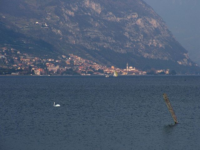
Vigolo is a picturesque region in northern Italy, often defined by its stunning natural landscapes and opportunities for outdoor activities, including hiking. While I don't have specific trails in Vigolo, I can provide some general insights into what you might expect when hiking in this area:
-
Scenic Trails: Vigolo is typically surrounded by mountains and lush countryside, offering a variety of hiking trails that cater to different skill levels, from easy walks suitable for families to challenging routes for experienced hikers.
-
Natural Beauty: Hikes in the Vigolo area can provide breathtaking views of the surrounding flora and fauna. You might encounter diverse ecosystems, including forests, pastures, and alpine meadows, which are perfect for both hiking and birdwatching.
-
Historical Sites: Some trails may lead to historical landmarks, ancient ruins, or charming villages where you can immerse yourself in local culture and history.
-
Weather Considerations: Be mindful of the weather, which can change rapidly in mountainous areas. It's essential to check the forecast and prepare accordingly with appropriate clothing and gear.
-
Local Map Resources: It's recommended to obtain local hiking maps or guides, which can provide detailed information about trail difficulty, lengths, and points of interest along the way.
-
Safety Tips: Always carry enough water, snacks, and a first aid kit. Let someone know your planned route and expected return time, especially for more remote areas.
-
Community: Engage with local hiking clubs or guides who can offer valuable insights and may host group hikes, providing an excellent opportunity to meet fellow outdoor enthusiasts.
For specific trail recommendations and additional information, checking with local tourism offices or hiking organizations would be beneficial. Have a great time exploring the beauty of Vigolo!
- Страна:

- Почтовый код: 24060
- Телефонный код: 035
- Код автомобильного номера: BG
- Координаты: 45° 43' 0" N, 10° 1' 0" E


- GPS треки (wikiloc): [Ссылка]
- Высота над уровнем моря: 616 м m
- Площадь: 12.31 кв.км
- Население: 579
- Веб сайт: http://www.comune.vigolo.bg.it/
- Википедия русская: wiki(ru)
- Википедия английская: wiki(en)
- Википедия национальная: wiki(it)
- Хранилище Wikidata: Wikidata: Q101756
- Галерея изображений в википедии: [Ссылка]
- Катеория в википедии: [Ссылка]
- код Freebase: [/m/0gjfs6]
- код GeoNames: Альт: [6539784]
- ID отношения в OpenStreetMap: [45809]
- UN/LOCODE: [ITVOO]
- код ISTAT: 016237
- кадастровый код Италии: L894
Граничит с регионами:


Фонтено
- коммуна Италии
Hiking in Фонтено
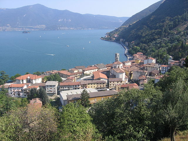
Fonteno is a charming town located in the province of Bergamo in Italy, perched on the hills overlooking Lake Iseo. It offers a variety of hiking opportunities that cater to different skill levels and preferences. Here are some highlights and tips for hiking in the Fonteno area:...
- Страна:
- Почтовый код: 24060
- Телефонный код: 035
- Код автомобильного номера: BG
- Координаты: 45° 46' 0" N, 10° 1' 0" E
- GPS треки (wikiloc): [Ссылка]
- Высота над уровнем моря: 606 м m
- Площадь: 10.93 кв.км
- Население: 583
- Веб сайт: [Ссылка]


Парцаника
- коммуна Италии
Hiking in Парцаника
Parzanica is a small village located in Italy, within the province of Bergamo in the Lombardy region. It sits on the eastern shore of Lake Iseo, surrounded by beautiful natural landscapes, making it a lovely destination for hiking enthusiasts. Here are some highlights about hiking in Parzanica:...
- Страна:
- Почтовый код: 24060
- Телефонный код: 035
- Код автомобильного номера: BG
- Координаты: 45° 44' 0" N, 10° 2' 0" E
- GPS треки (wikiloc): [Ссылка]
- Высота над уровнем моря: 753 м m
- Площадь: 9.82 кв.км
- Население: 362
- Веб сайт: [Ссылка]

Предоре
- коммуна Италии
Hiking in Предоре
Predore is a charming village located on the shores of Lake Iseo in northern Italy, making it a picturesque destination for hiking enthusiasts. While the village itself is relatively small, the surrounding area offers a variety of hiking trails that provide stunning views of the lake, nearby mountains, and the beautiful countryside....
- Страна:
- Почтовый код: 24060
- Телефонный код: 035
- Код автомобильного номера: BG
- Координаты: 45° 41' 0" N, 10° 1' 0" E
- GPS треки (wikiloc): [Ссылка]
- Высота над уровнем моря: 190 м m
- Площадь: 10.96 кв.км
- Население: 1864
- Веб сайт: [Ссылка]
Тавернола-Бергамаска
- коммуна Италии
Hiking in Тавернола-Бергамаска
Tavernola Bergamasca is a picturesque town located in the Bergamo province of Italy, overlooking Lago d'Iseo (Lake Iseo), which is known for its stunning landscapes, charming villages, and numerous hiking trails. Here are some highlights for hiking in and around Tavernola Bergamasca:...
- Страна:
- Почтовый код: 24060
- Телефонный код: 035
- Код автомобильного номера: BG
- Координаты: 45° 43' 0" N, 10° 3' 0" E
- GPS треки (wikiloc): [Ссылка]
- Высота над уровнем моря: 191 м m
- Площадь: 11.17 кв.км
- Население: 2042
- Веб сайт: [Ссылка]


Вьяданика
- коммуна Италии
Hiking in Вьяданика
Viadanica is a small village located in the province of Bergamo in northern Italy, nestled in the beautiful area of the Lombardy region. The surrounding natural landscapes and proximity to the Orobie Alps make it a charming destination for hikers and outdoor enthusiasts....
- Страна:
- Почтовый код: 24060
- Телефонный код: 035
- Код автомобильного номера: BG
- Координаты: 45° 41' 0" N, 9° 58' 0" E
- GPS треки (wikiloc): [Ссылка]
- Высота над уровнем моря: 336 м m
- Площадь: 5.45 кв.км
- Население: 1135
- Веб сайт: [Ссылка]


Адрара-Сан-Мартино
- коммуна Италии
Hiking in Адрара-Сан-Мартино
Adrara San Martino is a beautiful area located in the province of Bergamo in northern Italy. Known for its stunning landscapes, lush forests, and panoramic views, it offers a variety of hiking opportunities suitable for different skill levels. Here's what you need to know about hiking in this area:...
- Страна:
- Почтовый код: 24060
- Телефонный код: 035
- Код автомобильного номера: BG
- Координаты: 45° 42' 0" N, 9° 57' 0" E
- GPS треки (wikiloc): [Ссылка]
- Высота над уровнем моря: 355 м m
- Площадь: 12.61 кв.км
- Население: 2239
- Веб сайт: [Ссылка]


Адрара-Сан-Рокко
- коммуна Италии
Hiking in Адрара-Сан-Рокко
Adrara San Rocco is a picturesque village located in the province of Bergamo, northern Italy. The surrounding area is characterized by beautiful landscapes, lush forests, and a series of trails suitable for various hiking levels....
- Страна:
- Почтовый код: 24060
- Телефонный код: 035
- Код автомобильного номера: BG
- Координаты: 45° 42' 51" N, 9° 57' 30" E
- GPS треки (wikiloc): [Ссылка]
- Высота над уровнем моря: 431 м m
- Площадь: 9.23 кв.км
- Население: 825
- Веб сайт: [Ссылка]