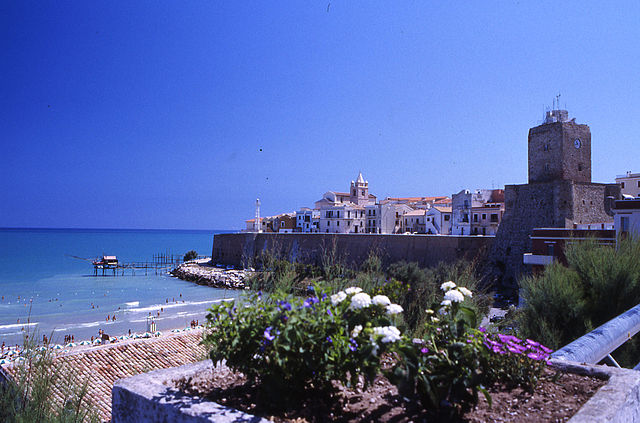
Петаччато (Petacciato, Petacciato)
.svg)
- коммуна Италии
 Hiking in Петаччато
Petacciato is a small town located in the Molise region of Italy, known for its beautiful landscapes, rolling hills, and proximity to the Adriatic Sea. Hiking in and around Petacciato can provide a wonderful experience for outdoor enthusiasts, with options for various skill levels. Here are some aspects to consider:
Trails and Routes
-
Nature Trails: The area features numerous trails through olive groves, vineyards, and along the hills. The views from higher elevations can be spectacular, offering glimpses of the Abruzzo mountains and the coastline.
-
Coastal Paths: You can explore trails that head toward the Adriatic Sea, where you can hike along the shoreline or through coastal parks.
-
Historical Routes: Some hikes may lead you through historical sites, such as ancient churches or remnants of old towns, perfect for those interested in culture as well as nature.
Difficulty Levels
- Easy Walks: There are flat, well-marked paths suitable for families and beginners wanting to enjoy a leisurely stroll.
- Moderate Hikes: For those looking for a bit more challenge, there are moderate hikes that involve some elevation gain and rocky areas.
- Challenging Trails: Experienced hikers may find routes that navigate steeper terrain and require more technical skills.
Best Times to Hike
- Spring (March to May): Ideal for wildflower blooms and comfortable temperatures.
- Fall (September to November): Offers beautiful foliage and mild weather.
- Summer (June to August): Can be hot, so early morning hikes are recommended.
Tips for Hiking in Petacciato
- Footwear: Ensure you wear appropriate hiking shoes for varied terrain.
- Water and Snacks: Carry enough water and some light snacks, especially for longer hikes.
- Map and Navigation: Have a map or download a hiking app to track your route.
- Local Regulations: Be aware of any local guidelines regarding trail usage, especially as some areas may have restrictions to protect wildlife or nature.
Nearby Attractions
After a day of hiking, consider exploring Petacciato itself or nearby towns such as Campobasso or Termoli, where you can enjoy local cuisine and culture.
Overall, hiking in Petacciato can be a rewarding experience that combines breathtaking views, diverse landscapes, and a touch of Italian culture.
- Страна:

- Почтовый код: 86038
- Телефонный код: 0875
- Код автомобильного номера: CB
- Координаты: 42° 1' 0" N, 14° 52' 0" E


- GPS треки (wikiloc): [Ссылка]
- Высота над уровнем моря: 225 м m
- Площадь: 35.4 кв.км
- Население: 3811
- Веб сайт: http://www.comune.petacciato.cb.it
- Википедия русская: wiki(ru)
- Википедия английская: wiki(en)
- Википедия национальная: wiki(it)
- Хранилище Wikidata: Wikidata: Q277853
- Катеория в википедии: [Ссылка]
- код Freebase: [/m/0bztj6]
- код GeoNames: Альт: [6540738]
- код VIAF: Альт: [242769437]
- ID отношения в OpenStreetMap: [41705]
- место в MusicBrainz: [c2bc73cc-42ca-48a7-9eaa-05f603805f58]
- UN/LOCODE: [ITPEI]
- код ISTAT: 070051
- кадастровый код Италии: G506
Граничит с регионами:

Термоли
- коммуна Италии
Hiking in Термоли
Termoli is a charming coastal town located in the Molise region of Italy, known for its beautiful beaches, historic architecture, and stunning views of the Adriatic Sea. While Termoli itself may not be renowned specifically for hiking, there are several opportunities for outdoor enthusiasts in the surrounding areas and nearby countryside. Here are some highlights for hiking in and around Termoli:...
- Страна:
- Почтовый код: 86039
- Телефонный код: 0875
- Код автомобильного номера: CB
- Координаты: 42° 0' 10" N, 14° 59' 41" E
- GPS треки (wikiloc): [Ссылка]
- Высота над уровнем моря: 15 м m
- Площадь: 55.64 кв.км
- Население: 33583
- Веб сайт: [Ссылка]


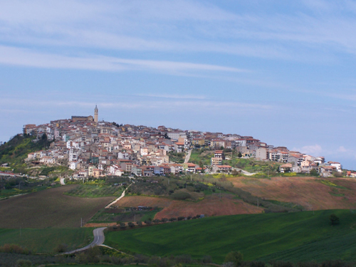
Гульонези
- коммуна Италии
Hiking in Гульонези
Guglionesi is a charming village located in the Molise region of Italy, surrounded by beautiful countryside and rolling hills, making it a great destination for hiking enthusiasts. Here's what you can expect when hiking in and around Guglionesi:...
- Страна:
- Почтовый код: 86034
- Телефонный код: 0875
- Код автомобильного номера: CB
- Координаты: 41° 55' 0" N, 14° 55' 0" E
- GPS треки (wikiloc): [Ссылка]
- Высота над уровнем моря: 369 м m
- Площадь: 100.95 кв.км
- Население: 5246
- Веб сайт: [Ссылка]
Монтенеро-ди-Бизачча
- коммуна Италии
Hiking in Монтенеро-ди-Бизачча
Montenero di Bisaccia is a charming town located in the Molise region of Italy, known for its beautiful landscapes and outdoor activities, including hiking. The area offers a unique blend of rolling hills, coastal views, and rustic countryside, making it an attractive spot for hikers seeking both tranquility and scenic beauty....
- Страна:
- Почтовый код: 86036
- Телефонный код: 0875
- Код автомобильного номера: CB
- Координаты: 41° 57' 0" N, 14° 47' 0" E
- GPS треки (wikiloc): [Ссылка]
- Высота над уровнем моря: 273 м m
- Площадь: 93.32 кв.км
- Население: 6612
- Веб сайт: [Ссылка]