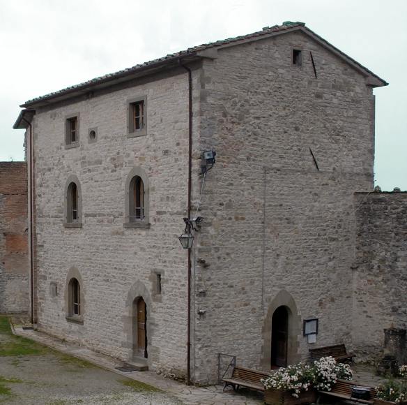
Пьеве-Санто-Стефано (Pieve Santo Stefano, Pieve Santo Stefano)
.svg)
- коммуна Италии
 Hiking in Пьеве-Санто-Стефано
Pieve Santo Stefano, located in Tuscany, Italy, is an enchanting destination for hikers. Nestled in the Casentino region, it offers a diverse range of trails that cater to various skill levels, all while showcasing stunning landscapes, rich history, and cultural heritage.
Hiking Trails:
-
Casentino Forests: The area is part of the Casentino Forests, Monte Falterona, and Campigna National Park. The park features numerous well-marked trails that wind through ancient beech woods, past streams, and meadows filled with wildflowers.
-
Monte Fanes: A popular hike is to Monte Fanes, where you can enjoy panoramic views of the surrounding valleys and mountains. The moderately challenging trails make it accessible for intermediate hikers.
-
Historical Trails: Some routes lead to historical sites, like old monasteries and castles, giving hikers a glimpse into the region's rich past while enjoying nature.
-
Village Walks: The town itself is charming for walking. You can explore its narrow streets, visit the local museum, which showcases the area's history, and enjoy the local cuisine in one of the restaurants.
Best Time to Hike:
- Spring and Fall: Ideal times for hiking, as the weather is mild, and the flora is vibrant.
- Summer: Can be warm, especially in the valley, so early morning hikes are recommended.
Tips for Hiking in Pieve Santo Stefano:
- Gear Up: Wear sturdy hiking boots and appropriate clothing for varying terrains.
- Check Trail Conditions: It's always wise to check trail conditions and weather forecasts before heading out.
- Stay Hydrated: Last but not least, carry enough water and snacks for energy.
Conclusion:
Hiking in Pieve Santo Stefano is a wonderful way to experience the natural beauty and cultural heritage of Tuscany. Whether you're hiking to enjoy the scenery, explore historical sites, or simply find peace in nature, this area has something to offer for everyone. Happy hiking!
- Страна:

- Почтовый код: 52036
- Телефонный код: 0575
- Код автомобильного номера: AR
- Координаты: 43° 40' 21" N, 12° 2' 32" E


- GPS треки (wikiloc): [Ссылка]
- Высота над уровнем моря: 431 м m
- Площадь: 156.1 кв.км
- Население: 3117
- Веб сайт: http://www.pievesantostefano.net/
- Википедия русская: wiki(ru)
- Википедия английская: wiki(en)
- Википедия национальная: wiki(it)
- Хранилище Wikidata: Wikidata: Q52094
- Катеория в википедии: [Ссылка]
- код Freebase: [/m/0gm0f6]
- код GeoNames: Альт: [6538592]
- код BNF: [150066139]
- код VIAF: Альт: [167899365]
- ID отношения в OpenStreetMap: [42531]
- код GND: Альт: [4793823-7]
- код LCNAF: Альт: [n95017462]
- WOEID: [720554]
- UN/LOCODE: [ITPSF]
- код автора openMLOL: [8932]
- код ISTAT: 051030
- кадастровый код Италии: G653
Граничит с регионами:


Ангьяри
- коммуна Италии
Hiking in Ангьяри
Anghiari is a charming medieval town located in the Tuscany region of Italy, known for its stunning landscapes, rich history, and well-preserved architecture. Hiking in and around Anghiari offers a variety of trails that showcase the beautiful countryside, rolling hills, and picturesque views unique to this part of Tuscany....
- Страна:
- Почтовый код: 52031
- Телефонный код: 0575
- Код автомобильного номера: AR
- Координаты: 43° 32' 30" N, 12° 3' 18" E
- GPS треки (wikiloc): [Ссылка]
- Высота над уровнем моря: 429 м m
- Площадь: 130.92 кв.км
- Население: 5536
- Веб сайт: [Ссылка]


Бадия-Тедальда
- коммуна Италии
Hiking in Бадия-Тедальда
Badia Tedalda is a beautiful destination located in the province of Arezzo in Tuscany, Italy. Nestled in the Valtiberina valley, this area is known for its stunning landscapes, rich history, and natural beauty, making it an excellent spot for hiking enthusiasts....
- Страна:
- Почтовый код: 53032
- Телефонный код: 0575
- Код автомобильного номера: AR
- Координаты: 43° 42' 29" N, 12° 11' 14" E
- GPS треки (wikiloc): [Ссылка]
- Высота над уровнем моря: 700 м m
- Площадь: 119.03 кв.км
- Население: 1075
- Веб сайт: [Ссылка]

Капрезе-Микеланджело
- коммуна Италии
Hiking in Капрезе-Микеланджело
Caprese Michelangelo, a small town in Tuscany, Italy, is surrounded by beautiful landscapes, making it a great destination for hikers. Nestled in the Casentino Forests, the area is characterized by its rich natural beauty, historical sites, and diverse flora and fauna....
- Страна:
- Почтовый код: 52033
- Телефонный код: 0575
- Код автомобильного номера: AR
- Координаты: 43° 38' 27" N, 11° 59' 9" E
- GPS треки (wikiloc): [Ссылка]
- Высота над уровнем моря: 653 м m
- Площадь: 66.53 кв.км
- Население: 1406
- Веб сайт: [Ссылка]
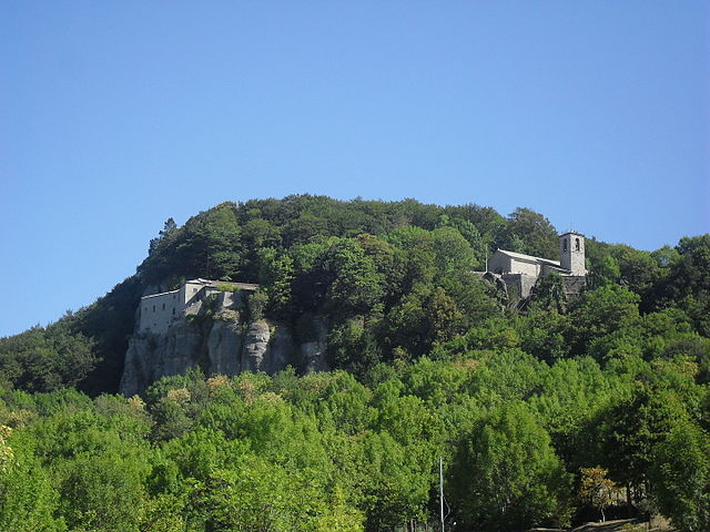

Кьюзи-делла-Верна
- коммуна Италии
Hiking in Кьюзи-делла-Верна
Chiusi della Verna, nestled in the Casentino Forests of Tuscany, Italy, is a fantastic destination for hikers. It offers a blend of natural beauty, historical significance, and a variety of trails catering to different skill levels. Here are some key points to consider when hiking in Chiusi della Verna:...
- Страна:
- Почтовый код: 52010
- Телефонный код: 0575
- Код автомобильного номера: AR
- Координаты: 43° 41' 54" N, 11° 56' 10" E
- GPS треки (wikiloc): [Ссылка]
- Высота над уровнем моря: 960 м m
- Площадь: 102.33 кв.км
- Население: 2000
- Веб сайт: [Ссылка]


Сансеполькро
- коммуна Италии
Hiking in Сансеполькро
Sansepolcro, located in the Toscano-Emiliano Apennines of Italy, is known not only for its rich history and art but also for its beautiful natural landscapes and hiking opportunities. Here are some highlights for hiking in and around Sansepolcro:...
- Страна:
- Почтовый код: 52037
- Телефонный код: 0575
- Код автомобильного номера: AR
- Координаты: 43° 34' 32" N, 12° 8' 38" E
- GPS треки (wikiloc): [Ссылка]
- Высота над уровнем моря: 330 м m
- Площадь: 91 кв.км
- Население: 15876
- Веб сайт: [Ссылка]
Вергерето
- коммуна регионе Эмилия-Романья, Италия
Hiking in Вергерето
Verghereto, located in the province of Forlì-Cesena in Emilia-Romagna, Italy, is an excellent destination for hiking enthusiasts. Nestled in the Apennine Mountains, the region is characterized by its stunning landscapes, lush forests, and a variety of trails suitable for different skill levels....
- Страна:
- Почтовый код: 47028
- Телефонный код: 0543
- Код автомобильного номера: FC
- Координаты: 43° 48' 0" N, 11° 58' 0" E
- GPS треки (wikiloc): [Ссылка]
- Высота над уровнем моря: 812 м m
- Площадь: 117.9 кв.км
- Население: 1860
- Веб сайт: [Ссылка]