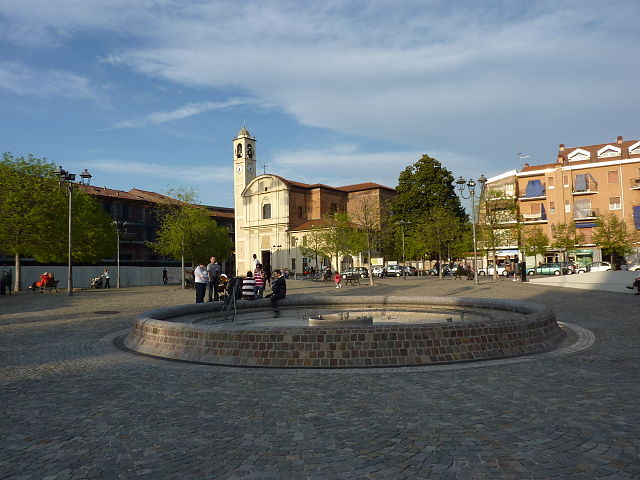
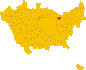
Пьольтелло (Pioltello, Pioltello)
.svg)
- коммуна Италии
 Hiking in Пьольтелло
Pioltello, a town located in the Lombardy region of Italy, is primarily an urban area and doesn’t have extensive hiking trails directly within its boundaries. However, it is situated near various natural reserves and parks in the surrounding areas, making it a good base for exploring some beautiful hiking trails nearby.
Here are a few options for hiking near Pioltello:
-
Parco Nord Milano: This large urban park is located to the northwest of Pioltello. It offers a mix of natural landscapes, walking paths, and cycling routes. The park covers over 600 hectares and features various flora and fauna, making it a lovely place for short hikes and nature walks.
-
Parco Agricolo Sud Milano: This agricultural park is located to the southwest and offers scenic routes through farmland, woods, and small rivers. You can find several trails for hiking and biking, and the area is known for its rural landscapes and charming villages.
-
Adda Park (Parco Adda): A bit further away, the Adda River Park offers more rugged hiking experiences. This park features beautiful river views, hills, and woodlands, and has well-marked trails. It’s ideal for those looking to escape the urban environment and enjoy nature.
-
Monte Stella: Located in Milan, this hill offers panoramic views of the city and surrounding areas. While it's not a traditional hiking destination, it has paths and trails suitable for short hikes and leisurely walks, especially for families.
-
The Martesana Canal: This canal connects Milan to the Adda River and has a lovely pathway running alongside it, perfect for walking, jogging, or cycling. It’s an excellent way to enjoy the landscape while getting some exercise.
If you're planning a hiking trip to the vicinity of Pioltello, consider checking local trail maps and connecting with local hiking groups for guided excursions or recommendations on the best routes. Always remember to carry water, wear appropriate footwear, and respect local wildlife and nature.
- Страна:

- Почтовый код: 20096
- Телефонный код: 02
- Код автомобильного номера: MI
- Координаты: 45° 30' 0" N, 9° 20' 0" E


- GPS треки (wikiloc): [Ссылка]
- Высота над уровнем моря: 122 м m
- Площадь: 13.09 кв.км
- Население: 37045
- Веб сайт: http://www.comune.pioltello.mi.it
- Википедия русская: wiki(ru)
- Википедия английская: wiki(en)
- Википедия национальная: wiki(it)
- Хранилище Wikidata: Wikidata: Q42785
- Катеория в википедии: [Ссылка]
- код Freebase: [/m/0gj745]
- код GeoNames: Альт: [6539485]
- код VIAF: Альт: [242302668]
- ID отношения в OpenStreetMap: [45095]
- идентификатор местоположения ArchINFORM: [46242]
- место в MusicBrainz: [3fb62988-f81a-4d58-838e-ac492a4931e7]
- UN/LOCODE: [ITPLO]
- код в Большой каталанской энциклопедии: [0051102]
- код ISTAT: 015175
- кадастровый код Италии: G686
Граничит с регионами:


Чернуско-суль-Навильо
- коммуна Италии
Hiking in Чернуско-суль-Навильо
Cernusco sul Naviglio, located in the metropolitan area of Milan, Italy, offers a unique blend of urban and natural landscapes, making it an interesting spot for hiking enthusiasts looking for a short escape from city life. While the area is more known for its proximity to urban environments, there are still opportunities to enjoy some scenic walks and hiking experiences....
- Страна:
- Почтовый код: 20063
- Телефонный код: 02
- Код автомобильного номера: MI
- Координаты: 45° 31' 0" N, 9° 20' 0" E
- GPS треки (wikiloc): [Ссылка]
- Высота над уровнем моря: 133 м m
- Площадь: 13.33 кв.км
- Население: 33867
- Веб сайт: [Ссылка]
Вимодроне
- коммуна Италии
Hiking in Вимодроне
Vimodrone is a small municipality located in the Lombardy region of Italy, situated just east of Milan. It is not primarily known for extensive hiking trails like some larger national parks or mountainous areas. However, it offers a pleasant environment for outdoor activities, including walking and cycling, with some scenic areas that can be explored in and around the town....
- Страна:
- Почтовый код: 20090
- Телефонный код: 02
- Код автомобильного номера: MI
- Координаты: 45° 30' 50" N, 9° 17' 4" E
- GPS треки (wikiloc): [Ссылка]
- Высота над уровнем моря: 128 м m
- Площадь: 6 кв.км
- Население: 17004
- Веб сайт: [Ссылка]


Родано
- коммуна Италии
Hiking in Родано
Rodano is a small town located in the Lombardy region of Italy, near Milan. While the area itself may not be known as a major hiking destination, it is conveniently located near several natural parks and hiking trails that can offer beautiful outdoor experiences....
- Страна:
- Почтовый код: 20090
- Телефонный код: 02
- Код автомобильного номера: MI
- Координаты: 45° 29' 0" N, 9° 21' 0" E
- GPS треки (wikiloc): [Ссылка]
- Высота над уровнем моря: 120 м m
- Площадь: 13.07 кв.км
- Население: 4651
- Веб сайт: [Ссылка]


Сеграте
- коммуна Италии
Hiking in Сеграте
Segrate, located in the Lombardy region of Italy, is part of the metropolitan area of Milan. While it might not be as famous for hiking as some other regions in Italy, it does offer some opportunities for outdoor enthusiasts. Here are some things to consider if you're looking to hike in and around Segrate:...
- Страна:
- Почтовый код: 20090
- Телефонный код: 02
- Код автомобильного номера: MI
- Координаты: 45° 29' 24" N, 9° 17' 43" E
- GPS треки (wikiloc): [Ссылка]
- Высота над уровнем моря: 115 м m
- Площадь: 17.49 кв.км
- Население: 35234
- Веб сайт: [Ссылка]


Пескьера-Борромео
- коммуна Италии
Hiking in Пескьера-Борромео
Peschiera Borromeo, located just southeast of Milan in Italy, is not primarily known for its extensive hiking trails compared to larger natural parks or mountainous regions. However, the area does offer some opportunities for leisurely walks and hikes, particularly in its green spaces and along the nearby waterways....
- Страна:
- Почтовый код: 20068
- Телефонный код: 02
- Код автомобильного номера: MI
- Координаты: 45° 26' 0" N, 9° 19' 0" E
- GPS треки (wikiloc): [Ссылка]
- Высота над уровнем моря: 107 м m
- Площадь: 23.22 кв.км
- Население: 23515
- Веб сайт: [Ссылка]