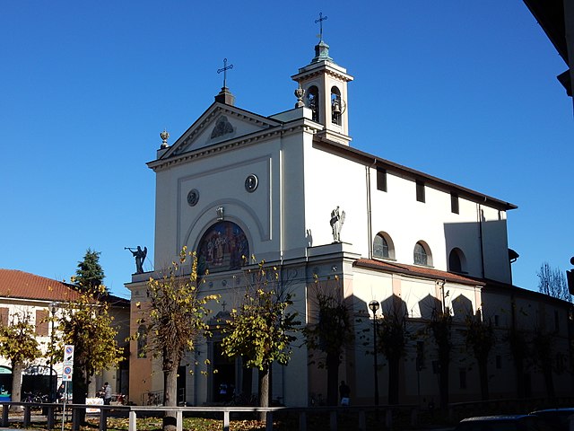
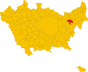
Родано (Rodano, Rodano)
.svg)
- коммуна Италии
 Hiking in Родано
Rodano is a small town located in the Lombardy region of Italy, near Milan. While the area itself may not be known as a major hiking destination, it is conveniently located near several natural parks and hiking trails that can offer beautiful outdoor experiences.
Nearby Hiking Areas:
-
Parco Agricolo Sud Milano: This is a large agricultural park located southwest of Rodano. It features a variety of trails that pass through picturesque countryside, vineyards, and charming villages. It's suitable for walking, cycling, and enjoying nature.
-
Parco Nord Milano: Located to the north, this city park has various walking and biking trails. It is a great spot for those looking for a quick escape into nature without venturing far from the Milan metropolitan area.
-
Adda River Path: A bit further out, the paths along the Adda River offer beautiful scenery and the opportunity to enjoy both leisurely walks and more intense hikes. The trails are well-marked and can take you through parks and historic sites.
Tips for Hiking in the Area:
- Stay Hydrated: Always carry enough water, particularly during warmer months.
- Check the Weather: Weather can change quickly; be prepared with appropriate clothing.
- Follow Local Guidelines: Stay on marked trails and respect private properties and wildlife.
- Consider Local Transport: If you're hiking in more distant areas, familiarize yourself with public transportation options for getting to trailheads.
Safety Considerations:
- Always let someone know your hiking plans.
- Consider carrying a map or using a GPS app to track your route.
- Be mindful of the time, especially if you're hiking in areas where it may get dark early.
By exploring the nearby parks and natural areas, you can enjoy a variety of hiking experiences while based in Rodano. Happy hiking!
- Страна:

- Почтовый код: 20090
- Телефонный код: 02
- Код автомобильного номера: MI
- Координаты: 45° 29' 0" N, 9° 21' 0" E


- GPS треки (wikiloc): [Ссылка]
- Высота над уровнем моря: 120 м m
- Площадь: 13.07 кв.км
- Население: 4651
- Веб сайт: http://www.comune.rodano.mi.it
- Википедия русская: wiki(ru)
- Википедия английская: wiki(en)
- Википедия национальная: wiki(it)
- Хранилище Wikidata: Wikidata: Q42528
- Катеория в википедии: [Ссылка]
- код Freebase: [/m/06rzw4]
- код GeoNames: Альт: [6540171]
- код VIAF: Альт: [300773652]
- ID отношения в OpenStreetMap: [45050]
- WOEID: [721914]
- UN/LOCODE: [ITRDN]
- код ISTAT: 015185
- кадастровый код Италии: H470
- LombardiaBeniCulturali toponym ID: 8000419
Граничит с регионами:


Чернуско-суль-Навильо
- коммуна Италии
Hiking in Чернуско-суль-Навильо
Cernusco sul Naviglio, located in the metropolitan area of Milan, Italy, offers a unique blend of urban and natural landscapes, making it an interesting spot for hiking enthusiasts looking for a short escape from city life. While the area is more known for its proximity to urban environments, there are still opportunities to enjoy some scenic walks and hiking experiences....
- Страна:
- Почтовый код: 20063
- Телефонный код: 02
- Код автомобильного номера: MI
- Координаты: 45° 31' 0" N, 9° 20' 0" E
- GPS треки (wikiloc): [Ссылка]
- Высота над уровнем моря: 133 м m
- Площадь: 13.33 кв.км
- Население: 33867
- Веб сайт: [Ссылка]


Пантильяте
- коммуна Италии
Hiking in Пантильяте
Pantigliate, located in the Metropolitan City of Milan in Italy, is not particularly known for extensive hiking trails like other more mountainous regions of Italy. However, its proximity to natural parks and green areas makes it a good base for outdoor activities, including hiking....
- Страна:
- Почтовый код: 20090
- Телефонный код: 02
- Код автомобильного номера: MI
- Координаты: 45° 26' 7" N, 9° 21' 8" E
- GPS треки (wikiloc): [Ссылка]
- Высота над уровнем моря: 102 м m
- Площадь: 5.69 кв.км
- Население: 6113
- Веб сайт: [Ссылка]


Сеттала
- коммуна Италии
Hiking in Сеттала
Settala, located in the Lombardy region of Italy, is not primarily known as a hiking destination compared to other areas in the region, such as the nearby Alps or Apennines. However, it offers some opportunities for outdoor activities and exploration of the surrounding natural beauty....
- Страна:
- Почтовый код: 20090
- Телефонный код: 02
- Код автомобильного номера: MI
- Координаты: 45° 27' 21" N, 9° 23' 31" E
- GPS треки (wikiloc): [Ссылка]
- Высота над уровнем моря: 108 м m
- Площадь: 17.42 кв.км
- Население: 7399
- Веб сайт: [Ссылка]
Пьольтелло
- коммуна Италии
Hiking in Пьольтелло
Pioltello, a town located in the Lombardy region of Italy, is primarily an urban area and doesn’t have extensive hiking trails directly within its boundaries. However, it is situated near various natural reserves and parks in the surrounding areas, making it a good base for exploring some beautiful hiking trails nearby....
- Страна:
- Почтовый код: 20096
- Телефонный код: 02
- Код автомобильного номера: MI
- Координаты: 45° 30' 0" N, 9° 20' 0" E
- GPS треки (wikiloc): [Ссылка]
- Высота над уровнем моря: 122 м m
- Площадь: 13.09 кв.км
- Население: 37045
- Веб сайт: [Ссылка]
Виньате
- коммуна Италии
Hiking in Виньате
Vignate is a small municipality located in the Lombardy region of Italy, near Milan. While it may not be predominantly known for extensive hiking trails as some larger national parks or mountainous regions, it can still serve as a starting point for hikes in the nearby areas....
- Страна:
- Почтовый код: 20060
- Телефонный код: 02
- Код автомобильного номера: MI
- Координаты: 45° 30' 0" N, 9° 22' 0" E
- GPS треки (wikiloc): [Ссылка]
- Высота над уровнем моря: 121 м m
- Площадь: 8.55 кв.км
- Население: 9309
- Веб сайт: [Ссылка]


Пескьера-Борромео
- коммуна Италии
Hiking in Пескьера-Борромео
Peschiera Borromeo, located just southeast of Milan in Italy, is not primarily known for its extensive hiking trails compared to larger natural parks or mountainous regions. However, the area does offer some opportunities for leisurely walks and hikes, particularly in its green spaces and along the nearby waterways....
- Страна:
- Почтовый код: 20068
- Телефонный код: 02
- Код автомобильного номера: MI
- Координаты: 45° 26' 0" N, 9° 19' 0" E
- GPS треки (wikiloc): [Ссылка]
- Высота над уровнем моря: 107 м m
- Площадь: 23.22 кв.км
- Население: 23515
- Веб сайт: [Ссылка]