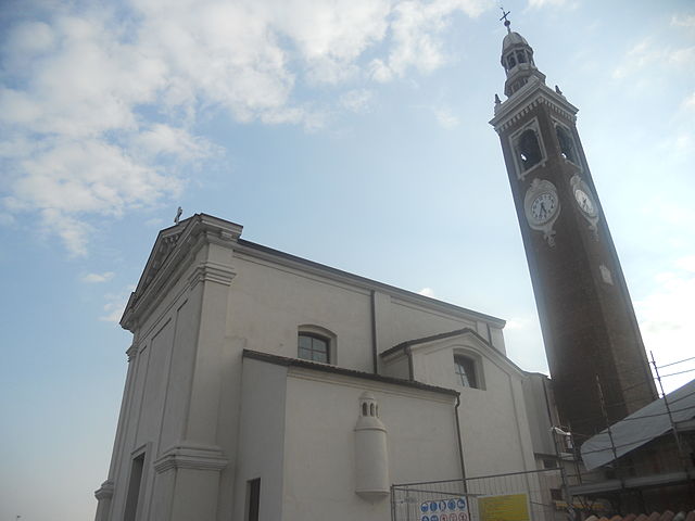
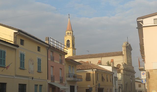
Пиццигеттоне (Pizzighettone, Pizzighettone)
.svg)
- коммуна Италии
 Hiking in Пиццигеттоне
Pizzighettone, located in the Lombardy region of Italy, offers a unique blend of history and nature for hiking enthusiasts. While it may not be as famous for hiking trails as some of the mountainous regions in Italy, it does have its own charm, particularly with its scenic surroundings and historical features.
Hiking Opportunities:
-
Ciclovia del Po: This cycling and hiking path runs along the Po River, allowing hikers to experience the tranquil landscape, wildlife, and charming villages along the way. It's ideal for those who enjoy flat, easy walks or rides with beautiful river views.
-
Local Trails: The area around Pizzighettone can provide various walking paths and trails that wind through the countryside and fields. These trails can lead you through picturesque farmland and quaint rural settings.
-
Historical Walks: As a town with a rich history, a walk through Pizzighettone itself can be a rewarding experience. You can explore the ancient walls, the fortress (Castello), and other historical landmarks while enjoying a leisurely walk.
-
Nearby Nature Reserves: The nearby Parco Naturale del Mincio, located to the south, is a great place for hiking if you’re willing to travel a bit for more extensive trails and diverse ecosystems, including wetlands and rich biodiversity.
Tips for Hiking in Pizzighettone:
- Prepare for Weather: The weather can vary, so dress in layers and be prepared for changing conditions.
- Footwear: Wear comfortable hiking shoes, especially if you’re exploring rural paths or uneven terrain.
- Hydration and Snacks: Carry plenty of water and snacks, especially if you plan to hike for several hours.
- Respect Nature: Follow Leave No Trace principles to preserve the natural beauty and environment.
Conclusion
While Pizzighettone may not be a premier hiking destination, it offers delightful walks through history, riverside paths, and the opportunity to explore the Lombardy countryside. If you’re in the area, it can be a lovely spot for a leisurely day of hiking.
- Страна:

- Почтовый код: 26026
- Телефонный код: 0372
- Код автомобильного номера: CR
- Координаты: 45° 11' 0" N, 9° 47' 0" E


- GPS треки (wikiloc): [Ссылка]
- Высота над уровнем моря: 46 м m
- Площадь: 32.06 кв.км
- Население: 6501
- Веб сайт: http://www.comune.pizzighettone.cr.it/
- Википедия русская: wiki(ru)
- Википедия английская: wiki(en)
- Википедия национальная: wiki(it)
- Хранилище Wikidata: Wikidata: Q42619
- Галерея изображений в википедии: [Ссылка]
- Катеория в википедии: [Ссылка]
- код Freebase: [/m/0c706l]
- код GeoNames: Альт: [6536212]
- код VIAF: Альт: [129155812]
- ID отношения в OpenStreetMap: [44357]
- WOEID: [720659]
- UN/LOCODE: [ITZRI]
- код ISTAT: 019076
- кадастровый код Италии: G721
Граничит с регионами:


Корновеккьо
- коммуна Италии
Hiking in Корновеккьо
Cornovecchio, a small municipality in the Lombardy region of Italy, is not as widely known for hiking as some of the bigger national parks or mountainous areas in the country. However, the surrounding areas offer a unique experience for those interested in exploring rural landscapes, historical sites, and local flora and fauna....
- Страна:
- Почтовый код: 26842
- Телефонный код: 0377
- Код автомобильного номера: LO
- Координаты: 45° 8' 15" N, 9° 48' 1" E
- GPS треки (wikiloc): [Ссылка]
- Высота над уровнем моря: 52 м m
- Площадь: 6.53 кв.км
- Население: 213
- Веб сайт: [Ссылка]


Камайраго
- коммуна Италии
Hiking in Камайраго
Camairago, a small town in the Lombardy region of Italy, is not primarily known as a hiking destination. However, its surrounding areas offer opportunities for hiking and enjoying nature. While the town itself may not have extensive trails, you can explore nearby regions for outdoor activities....
- Страна:
- Почтовый код: 26823
- Телефонный код: 0377
- Код автомобильного номера: LO
- Координаты: 45° 12' 22" N, 9° 43' 42" E
- GPS треки (wikiloc): [Ссылка]
- Высота над уровнем моря: 53 м m
- Площадь: 12.77 кв.км
- Население: 643
- Веб сайт: [Ссылка]

Формигара
- коммуна Италии
Hiking in Формигара
Formigara is a lesser-known yet beautiful hiking destination in Italy, nestled within the picturesque Pavia province of Lombardy. It is part of the larger Lombardy region, known for its stunning landscapes, historical sites, and diverse flora and fauna. While Formigara itself may not be a prominent hiking area like some of the more famous national parks or mountains in Italy, it offers a serene environment for nature lovers and hikers....
- Страна:
- Почтовый код: 26020
- Телефонный код: 0374
- Код автомобильного номера: CR
- Координаты: 45° 14' 0" N, 9° 46' 0" E
- GPS треки (wikiloc): [Ссылка]
- Высота над уровнем моря: 56 м m
- Площадь: 12.64 кв.км
- Население: 1031
- Веб сайт: [Ссылка]
Каппелла-Кантоне
- коммуна Италии
Hiking in Каппелла-Кантоне
Cappella Cantone is a charming town located in the province of Cremona in Italy. While it may not be as widely known for hiking as some of Italy's more famous regions, it is surrounded by beautiful landscapes and offers opportunities for outdoor activities....
- Страна:
- Почтовый код: 26020
- Телефонный код: 0374
- Код автомобильного номера: CR
- Координаты: 45° 15' 0" N, 9° 50' 0" E
- GPS треки (wikiloc): [Ссылка]
- Высота над уровнем моря: 60 м m
- Площадь: 13.15 кв.км
- Население: 576
- Веб сайт: [Ссылка]
Кротта-д'Адда
- коммуна Италии
Hiking in Кротта-д'Адда
Crotta d'Adda is a picturesque village located in the Lombardy region of Italy, near the Adda River. While it's not widely known as a hiking destination, it offers some beautiful trails and scenic views for outdoor enthusiasts. Here are some aspects to consider when hiking in and around Crotta d'Adda:...
- Страна:
- Почтовый код: 26020
- Телефонный код: 0372
- Код автомобильного номера: CR
- Координаты: 45° 10' 0" N, 9° 51' 0" E
- GPS треки (wikiloc): [Ссылка]
- Высота над уровнем моря: 52 м m
- Площадь: 12.94 кв.км
- Население: 641
- Веб сайт: [Ссылка]

Сан-Бассано
- коммуна Италии
Hiking in Сан-Бассано
San Bassano is a picturesque area known for its natural beauty and hiking opportunities. While it may specifically refer to a region in Italy, I can provide general insights into hiking in regions that might be similar in nature or atmosphere. The following are some considerations and tips for hiking in such areas:...
- Страна:
- Почтовый код: 26020
- Телефонный код: 0374
- Код автомобильного номера: CR
- Координаты: 45° 14' 38" N, 9° 48' 32" E
- GPS треки (wikiloc): [Ссылка]
- Высота над уровнем моря: 59 м m
- Площадь: 13.93 кв.км
- Население: 2162
- Веб сайт: [Ссылка]


Грумелло-Кремонезе-эд-Унити
- коммуна Италии
Hiking in Грумелло-Кремонезе-эд-Унити
Grumello Cremonese ed Uniti, a small municipality in the province of Cremona in Lombardy, Italy, is a lesser-known gem for hiking enthusiasts. While it may not have the established hiking trails found in larger national parks or mountainous regions, the area offers some delightful countryside routes and opportunities to explore the scenic landscapes....
- Страна:
- Почтовый код: 26023
- Телефонный код: 0372
- Код автомобильного номера: CR
- Координаты: 45° 11' 39" N, 9° 51' 52" E
- GPS треки (wikiloc): [Ссылка]
- Высота над уровнем моря: 50 м m
- Площадь: 22.29 кв.км
- Население: 1789
- Веб сайт: [Ссылка]


Малео
- апап
Hiking in Малео
Maleo is a charming town located in the province of Lodi in Lombardy, Italy. While Maleo itself may not be a well-known hiking destination, it is surrounded by beautiful natural landscapes and offers access to various paths and trails for outdoor enthusiasts. Here are some aspects of hiking in and around Maleo:...
- Страна:
- Почтовый код: 26847
- Телефонный код: 0377
- Код автомобильного номера: LO
- Координаты: 45° 10' 6" N, 9° 45' 45" E
- GPS треки (wikiloc): [Ссылка]
- Высота над уровнем моря: 58 м m
- Площадь: 19.83 кв.км
- Население: 3133
- Веб сайт: [Ссылка]