
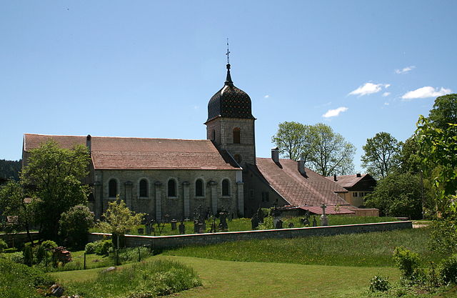
Понтарлье (Pontarlier, Pontarlier)

- коммуна во Франции
 Hiking in Понтарлье
Pontarlier, located in the Doubs department of the Bourgogne-Franche-Comté region in eastern France, is a great base for hiking enthusiasts. Known for its stunning natural landscapes, the area features a mix of forests, mountains, and picturesque valleys.
Popular Hiking Trails:
-
Les Lacs de Vaux: This area offers a series of lakes surrounded by lush forests. The trails around the lakes provide beautiful views and a chance to spot local wildlife.
-
Mont d'Or: A more challenging hike, Mont d'Or is known for its panoramic views of the surrounding Jura mountains and valleys. The summit can be accessed via several trails, with varying levels of difficulty.
-
The Grande Traversée du Jura: This long-distance trail crosses the Jura mountain range and includes sections that pass near Pontarlier. Hikers can experience diverse terrains, including forest paths and open plateaus.
-
Cascades du Hérisson: While a bit farther from Pontarlier, this hike leads to beautiful waterfalls and offers various loops that can be adjusted in length.
Tips for Hiking in Pontarlier:
-
Prepare for Weather Changes: The weather can be quite variable, particularly in mountainous areas, so layering your clothing is advisable.
-
Local Maps and Guides: Consider picking up local hiking maps or guides available at tourist information centers. These can help you find trails suited to your skill level.
-
Respect Wildlife: The area is home to various species, so it's important to stay on marked trails and respect the natural habitat.
-
Hydration and Nutrition: Always carry sufficient water and snacks, especially on longer hikes.
-
Safety: Inform someone about your hiking plans and expected return time, especially if venturing into less crowded areas.
Pontarlier and its surrounding regions offer a wealth of hiking opportunities that cater to all levels, making it a wonderful destination for outdoor enthusiasts. Whether you're looking for a leisurely walk or a more strenuous trek, there's something here for everyone!
- Страна:

- Почтовый код: 25300
- Координаты: 46° 54' 22" N, 6° 21' 17" E


- GPS треки (wikiloc): [Ссылка]
- Высота над уровнем моря: 837 м m
- Площадь: 41.35 кв.км
- Население: 17140
- Веб сайт: http://www.ville-pontarlier.fr
- Википедия русская: wiki(ru)
- Википедия английская: wiki(en)
- Википедия национальная: wiki(fr)
- Хранилище Wikidata: Wikidata: Q214540
- Катеория в википедии: [Ссылка]
- Карты в википедии: [Ссылка]
- код Freebase: [/m/03yqq1]
- код Freebase: [/m/03yqq1]
- код GeoNames: Альт: [2986302]
- код GeoNames: Альт: [2986302]
- номер SIREN: [212504625]
- номер SIREN: [212504625]
- код BNF: [15252688m]
- код BNF: [15252688m]
- код VIAF: Альт: [153628832]
- код VIAF: Альт: [153628832]
- код GND: Альт: [4116036-8]
- код GND: Альт: [4116036-8]
- код LCNAF: Альт: [n82093935]
- код LCNAF: Альт: [n82093935]
- код тезауруса PACTOLS: [pcrtkHyShd22f5]
- код тезауруса PACTOLS: [pcrtkHyShd22f5]
- место в MusicBrainz: [4835c797-3b71-4a6c-b911-58a200e2b048]
- место в MusicBrainz: [4835c797-3b71-4a6c-b911-58a200e2b048]
- WOEID: [617416]
- WOEID: [617416]
- код TGN: [7009439]
- код TGN: [7009439]
- код муниципалитета INSEE: 25462
- код муниципалитета INSEE: 25462
Граничит с регионами:


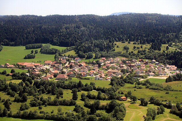
Ла-Клюз-э-Мижу
- коммуна во Франции
Hiking in Ла-Клюз-э-Мижу
La Cluse-et-Mijoux is a picturesque commune located in the Doubs department of the Bourgogne-Franche-Comté region in eastern France. Nestled in the Jura mountains, it offers beautiful landscapes, lush forests, and scenic views, making it a great destination for hiking enthusiasts....
- Страна:
- Почтовый код: 25300
- Координаты: 46° 52' 19" N, 6° 22' 43" E
- GPS треки (wikiloc): [Ссылка]
- Площадь: 22.5 кв.км
- Население: 1318
- Веб сайт: [Ссылка]


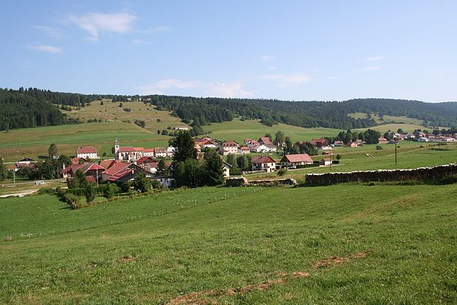
Doubs
- коммуна во Франции
Hiking in Doubs
Doubs, a department in the Bourgogne-Franche-Comté region of eastern France, offers a variety of stunning hiking opportunities. The picturesque landscapes, characterized by rolling hills, forests, valleys, and the Doubs River, make it a popular destination for outdoor enthusiasts....
- Страна:
- Почтовый код: 25300
- Координаты: 46° 55' 36" N, 6° 21' 0" E
- GPS треки (wikiloc): [Ссылка]
- Высота над уровнем моря: 813 м m
- Площадь: 8.94 кв.км
- Население: 2888
- Веб сайт: [Ссылка]

Arçon
- коммуна во Франции
Hiking in Arçon
Arçon is a beautiful location located in the Jura region of France, known for its stunning landscapes, diverse flora, and ample opportunities for hiking enthusiasts. Here are some key points to consider when planning a hiking trip in Arçon:...
- Страна:
- Почтовый код: 25300
- Координаты: 46° 56' 51" N, 6° 22' 44" E
- GPS треки (wikiloc): [Ссылка]
- Площадь: 21.34 кв.км
- Население: 820


Les Alliés
- коммуна во Франции
Hiking in Les Alliés
Les Alliés, typically referred to in the context of hiking, is likely a region in France known for its scenic landscapes and outdoor activities. However, it’s essential to clarify that "Les Alliés" may not be a well-known hiking destination compared to other regions in France, such as the Alps or the Pyrenees....
- Страна:
- Почтовый код: 25300
- Координаты: 46° 56' 53" N, 6° 26' 51" E
- GPS треки (wikiloc): [Ссылка]
- Площадь: 5.28 кв.км
- Население: 142


Dommartin
Hiking in Dommartin
Dommartin, located in the Doubs department of the Bourgogne-Franche-Comté region in France, offers beautiful landscapes and various hiking opportunities suitable for different experience levels. The area is characterized by rolling hills, dense forests, and scenic views, making it a great destination for nature lovers and outdoor enthusiasts....
- Страна:
- Почтовый код: 25300
- Координаты: 46° 55' 29" N, 6° 18' 25" E
- GPS треки (wikiloc): [Ссылка]
- Площадь: 6.39 кв.км
- Население: 677
- Веб сайт: [Ссылка]


Maisons-du-Bois-Lièvremont
- коммуна во Франции
Hiking in Maisons-du-Bois-Lièvremont
Maisons-du-Bois-Lièvremont, located in the Jura Mountains of France, is a charming destination for hiking enthusiasts. This small commune is known for its stunning natural landscapes, lush forests, and picturesque trails, making it an excellent spot for outdoor activities....
- Страна:
- Почтовый код: 25650
- Координаты: 46° 58' 2" N, 6° 25' 13" E
- GPS треки (wikiloc): [Ссылка]
- Площадь: 15.79 кв.км
- Население: 770


Houtaud
- коммуна во Франции
Hiking in Houtaud
Houtaud, a quaint village in the Jura region of France, offers some beautiful hiking opportunities that showcase the area’s stunning landscapes, including rolling hills, dense forests, and expansive views of the surrounding countryside. Here are some key points about hiking in Houtaud:...
- Страна:
- Почтовый код: 25300
- Координаты: 46° 54' 56" N, 6° 18' 43" E
- GPS треки (wikiloc): [Ссылка]
- Площадь: 7.89 кв.км
- Население: 1055
- Веб сайт: [Ссылка]

Granges-Narboz
- коммуна во Франции
Hiking in Granges-Narboz
Granges-Narboz, located in the Jura mountains of France, offers various hiking opportunities for nature enthusiasts and outdoor adventurers. This picturesque area is characterized by rolling hills, dense forests, and stunning views of the surrounding landscapes, making it a great spot for hiking....
- Страна:
- Почтовый код: 25300
- Координаты: 46° 52' 45" N, 6° 18' 38" E
- GPS треки (wikiloc): [Ссылка]
- Площадь: 16.22 кв.км
- Население: 1170
- Веб сайт: [Ссылка]

Verrières-de-Joux
- коммуна во Франции
Hiking in Verrières-de-Joux
Verrières-de-Joux is a picturesque village in the Jura mountains of Switzerland, known for its stunning natural scenery and outdoor activities, making it a great destination for hiking enthusiasts. Here are some key highlights and tips for hiking in this area:...
- Страна:
- Почтовый код: 25300
- Координаты: 46° 53' 48" N, 6° 26' 57" E
- GPS треки (wikiloc): [Ссылка]
- Высота над уровнем моря: 927 м m
- Площадь: 10.15 кв.км
- Население: 419
- Веб сайт: [Ссылка]