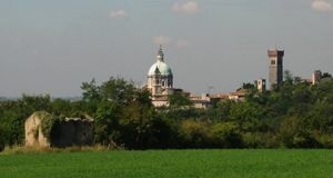
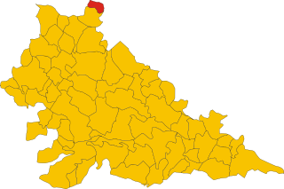
Поццоленго (Pozzolengo, Pozzolengo)
.svg)
- коммуна Италии
 Hiking in Поццоленго
Pozzolengo is a charming village located in the Lombardy region of Italy, near Lake Garda. The surrounding area offers a variety of hiking opportunities, characterized by beautiful landscapes, vineyards, olive groves, and historic sites.
Key Hiking Trails and Areas
-
Morainic Hills: The landscape of the Morainic Hills around Pozzolengo provides several trails that meander through rolling hills and breathtaking scenery. The area features vineyards, and you can often spot local wildlife.
-
Monte Varino: This is a popular route for hikers, offering stunning panoramic views of the surrounding regions, including Lake Garda. The ascent is moderately challenging and rewards you with picturesque landscapes.
-
Cavalca Trail: A scenic trail that runs through the countryside, often passing by historical sites, such as old churches and ancient ruins, providing a glimpse into the local history.
-
Bikes & Hikes: The area is also great for biking and combining hikes with bike rides. Many trails are shared, allowing for a versatile outdoor experience.
Tips for Hiking in Pozzolengo
-
Preparation: Ensure you have good hiking shoes and enough water, especially during the warmer months. Sun protection is also advisable.
-
Weather: Check the weather forecast before heading out, as conditions can change rapidly in the hills.
-
Trail Markings: Familiarize yourself with the trail markings or consider bringing a GPS device or map, as some trails might not be clearly marked.
-
Local Advice: Engaging with local guides or visiting local tourist offices can provide updated information on trail conditions and recommendations for the best routes.
-
Respect Nature: Follow Leave No Trace principles to preserve the beautiful environment for future visitors.
Conclusion
Hiking in Pozzolengo allows you to immerse yourself in nature while enjoying the stunning views and rich history of the area. Whether you’re a beginner or an experienced hiker, there are trails suited for all levels, making it a perfect destination for outdoor enthusiasts.
- Страна:

- Почтовый код: 25010
- Телефонный код: 030
- Код автомобильного номера: BS
- Координаты: 45° 24' 25" N, 10° 38' 2" E


- GPS треки (wikiloc): [Ссылка]
- Высота над уровнем моря: 135 м m
- Площадь: 21.33 кв.км
- Население: 3558
- Веб сайт: http://www.comune.pozzolengo.bs.it
- Википедия русская: wiki(ru)
- Википедия английская: wiki(en)
- Википедия национальная: wiki(it)
- Хранилище Wikidata: Wikidata: Q111473
- Катеория в википедии: [Ссылка]
- код Freebase: [/m/047d9_]
- код GeoNames: Альт: [6540194]
- код VIAF: Альт: [234823719]
- ID отношения в OpenStreetMap: [44894]
- UN/LOCODE: [ITPZZ]
- код ISTAT: 017151
- кадастровый код Италии: G959
Граничит с регионами:

Дезенцано-дель-Гарда
- коммуна Италии
Hiking in Дезенцано-дель-Гарда
Desenzano del Garda, located on the southern shore of Lake Garda in Italy, offers a beautiful landscape for hiking enthusiasts. The area is characterized by a mix of rolling hills, vineyards, olive groves, and stunning lake views, making it a fantastic destination for outdoor activities....
- Страна:
- Почтовый код: 25015
- Телефонный код: 030
- Код автомобильного номера: BS
- Координаты: 45° 28' 8" N, 10° 32' 6" E
- GPS треки (wikiloc): [Ссылка]
- Высота над уровнем моря: 96 м m
- Площадь: 59.26 кв.км
- Население: 28982
- Веб сайт: [Ссылка]
Лонато-дель-Гарда
- коммуна Италии
Hiking in Лонато-дель-Гарда
Lonato del Garda, located in the Lombardy region of northern Italy, is a beautiful area that offers various hiking opportunities, particularly due to its proximity to Lake Garda and the surrounding hills. Here are some key points to consider if you're planning a hiking trip in this region:...
- Страна:
- Почтовый код: 25017
- Телефонный код: 030
- Код автомобильного номера: BS
- Координаты: 45° 27' 39" N, 10° 28' 38" E
- GPS треки (wikiloc): [Ссылка]
- Высота над уровнем моря: 170 м m
- Площадь: 68.2 кв.км
- Население: 16506
- Веб сайт: [Ссылка]

Понти-суль-Минчо
- коммуна Италии
Hiking in Понти-суль-Минчо
Ponti sul Mincio is a picturesque village in the Lombardy region of northern Italy, located near the Mincio River. This area is renowned for its natural beauty, historical significance, and opportunities for outdoor activities such as hiking....
- Страна:
- Почтовый код: 46040
- Телефонный код: 0376
- Код автомобильного номера: MN
- Координаты: 45° 23' 0" N, 10° 42' 0" E
- GPS треки (wikiloc): [Ссылка]
- Высота над уровнем моря: 113 м m
- Площадь: 11.72 кв.км
- Население: 2417
- Веб сайт: [Ссылка]

Кавриана
- коммуна Италии
Hiking in Кавриана
Cavriana is a charming town located in the Lombardy region of Italy, surrounded by beautiful landscapes that are perfect for hiking. The area is characterized by gentle hills, vineyards, and historic sites, making it an attractive destination for hikers of all levels....
- Страна:
- Почтовый код: 46040
- Телефонный код: 0376
- Код автомобильного номера: MN
- Координаты: 45° 21' 0" N, 10° 36' 0" E
- GPS треки (wikiloc): [Ссылка]
- Высота над уровнем моря: 170 м m
- Площадь: 36.91 кв.км
- Население: 3828
- Веб сайт: [Ссылка]


Монцамбано
- коммуна Италии
Hiking in Монцамбано
Monzambano is a charming village located in the Lombardy region of Italy, near the southern shore of Lake Garda. The area is known for its beautiful landscapes, rolling hills, and historic sites, making it a good location for hiking and outdoor activities....
- Страна:
- Почтовый код: 46040
- Телефонный код: 0376
- Код автомобильного номера: MN
- Координаты: 45° 23' 0" N, 10° 42' 0" E
- GPS треки (wikiloc): [Ссылка]
- Высота над уровнем моря: 88 м m
- Площадь: 30.02 кв.км
- Население: 4877
- Веб сайт: [Ссылка]
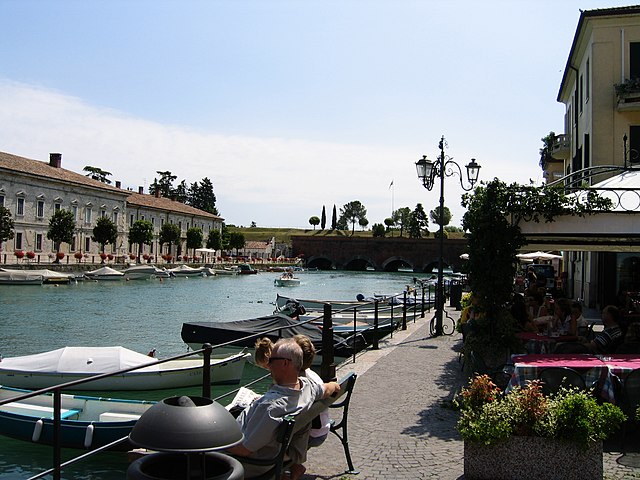
Пескьера-дель-Гарда
- коммуна Италии
Hiking in Пескьера-дель-Гарда
Peschiera del Garda, located on the southeastern shore of Lake Garda in Italy, is not only a picturesque town known for its charming canals and historical architecture but also an excellent base for hiking enthusiasts. The surrounding landscapes offer a variety of trails, ranging from easy walks to more challenging hikes, suitable for all skill levels....
- Страна:
- Почтовый код: 37010; 37019
- Телефонный код: 045
- Код автомобильного номера: VR
- Координаты: 45° 26' 19" N, 10° 41' 19" E
- GPS треки (wikiloc): [Ссылка]
- Высота над уровнем моря: 68 м m
- Площадь: 18.27 кв.км
- Население: 10583
- Веб сайт: [Ссылка]