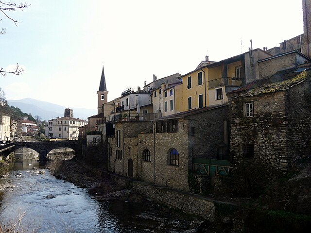
Прела (Prelà, Prelà)
.svg)
- коммуна Италии
 Hiking in Прела
Prelà is a charming village located in the Liguria region of Italy, known for its lush landscapes and proximity to the beautiful Italian Riviera. Hiking in and around Prelà offers a range of experiences, from gentle walks through olive groves to more challenging trails with stunning views of the surrounding mountains and coastline.
Hiking Trails in Prelà
-
The Olive Grove Trails: One of the most popular areas for hiking around Prelà is the scenic olive groves. These trails provide a gentle ascent and are perfect for families or those looking for a leisurely stroll. The paths are often well-marked and can lead to panoramic views of the surrounding hills.
-
The Alta Via dei Monti Liguri: Some sections of this long-distance trail can be accessed from Prelà. This route traverses the Ligurian mountains and offers breathtaking views, passing through various natural landscapes, including forests and mountain ridges.
-
Hiking to the Cascate di San Bartolomeo: This trail takes you to beautiful waterfalls located near the village. The route can be a bit rugged, offering a good mix of exploration and adventure.
-
Sanctuary of San Michele: A hike up to this sanctuary offers not only the spiritual experience of visiting the site but also fantastic views of the surrounding countryside and the coast.
Tips for Hiking in Prelà
-
Weather: Always check the weather conditions before heading out. Spring and early fall are the best seasons for hiking in this region, as the temperatures are mild, and the scenery is vibrant.
-
Hydration and Snacks: Bring plenty of water and snacks, particularly if you plan to hike longer trails. Some areas may not have facilities nearby.
-
Local Maps: It's advisable to carry a detailed map or a GPS device, as some trails may not be well-marked.
-
Respect Nature: Always stick to marked trails, take your litter home, and be mindful of local wildlife.
-
Local Guides: If you’re unfamiliar with the area, consider hiring a local guide who can provide valuable insights about the trails and the region’s cultural heritage.
Hiking around Prelà allows you to immerse yourself in the natural beauty of Liguria, offering both relaxation and adventure in a picturesque setting.
- Страна:

- Почтовый код: 18020
- Телефонный код: 0183
- Код автомобильного номера: IM
- Координаты: 43° 55' 26" N, 7° 54' 33" E


- GPS треки (wikiloc): [Ссылка]
- Высота над уровнем моря: 151 м m
- Площадь: 14.8 кв.км
- Население: 498
- Веб сайт: http://www.comune.prela.im.it/
- Википедия русская: wiki(ru)
- Википедия английская: wiki(en)
- Википедия национальная: wiki(it)
- Хранилище Wikidata: Wikidata: Q269688
- Катеория в википедии: [Ссылка]
- код Freebase: [/m/0gbz15]
- код GeoNames: Альт: [3169866]
- ID отношения в OpenStreetMap: [42747]
- идентификатор местоположения ArchINFORM: [9520]
- код ISTAT: 008047
- кадастровый код Италии: H027
Граничит с регионами:

Боргомаро
- коммуна Италии
Hiking in Боргомаро
Borgomaro is a picturesque village located in the Liguria region of Italy, nestled in the foothills of the Maritime Alps. The area offers beautiful hiking opportunities, featuring lush landscapes, charming villages, and stunning views of the surrounding mountains and valleys....
- Страна:
- Почтовый код: 18021
- Телефонный код: 0183
- Код автомобильного номера: IM
- Координаты: 43° 58' 32" N, 7° 56' 41" E
- GPS треки (wikiloc): [Ссылка]
- Высота над уровнем моря: 200 м m
- Площадь: 23.44 кв.км
- Население: 881
- Веб сайт: [Ссылка]


Дольчедо
- коммуна Италии
Hiking in Дольчедо
Dolcedo, a charming village located in the Italian Riviera region of Liguria, offers a great backdrop for hiking enthusiasts. Nestled in a picturesque valley, surrounded by ancient olive groves and Mediterranean vegetation, Dolcedo provides an array of hiking trails that cater to various skill levels....
- Страна:
- Почтовый код: 18020
- Телефонный код: 0183
- Код автомобильного номера: IM
- Координаты: 43° 54' 25" N, 7° 57' 6" E
- GPS треки (wikiloc): [Ссылка]
- Высота над уровнем моря: 75 м m
- Площадь: 19.8 кв.км
- Население: 1385
- Веб сайт: [Ссылка]


Вазия
- коммуна Италии
Hiking in Вазия
Vasia, located in the Liguria region of Italy, is a charming destination for hikers looking to explore picturesque landscapes and enjoy the serenity of nature. The area offers a variety of trails suitable for different skill levels, ranging from leisurely walks to more challenging hikes....
- Страна:
- Почтовый код: 18020
- Телефонный код: 0183
- Код автомобильного номера: IM
- Координаты: 43° 56' 0" N, 7° 57' 16" E
- GPS треки (wikiloc): [Ссылка]
- Высота над уровнем моря: 385 м m
- Площадь: 11.15 кв.км
- Население: 405
- Веб сайт: [Ссылка]