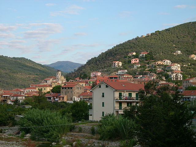
Вазия (Vasia, Vasia)
.svg)
- коммуна Италии
 Hiking in Вазия
Vasia, located in the Liguria region of Italy, is a charming destination for hikers looking to explore picturesque landscapes and enjoy the serenity of nature. The area offers a variety of trails suitable for different skill levels, ranging from leisurely walks to more challenging hikes.
Key Highlights for Hiking in Vasia:
-
Scenic Views: The trails in Vasia feature stunning views of the surrounding hills, olive groves, and the distant coastline of the Italian Riviera. The lush vegetation and vibrant wildflowers in the spring add a special charm to the hikes.
-
Nature Trails: Many trails in and around Vasia are well-marked and allow hikers to experience the local flora and fauna. The region is known for its biodiversity, so keep an eye out for birds and various plant species along your route.
-
Historical Sites: Some hiking routes may lead to historical landmarks or quaint villages, providing an opportunity to explore local culture and architecture. Don't forget to stop and enjoy local cuisine at small trattorias or cafés.
-
Loop Trails: Many hikes in the area are loop trails, which means you can complete your hike without retracing your steps. This can add variety to your hike and allow you to see different perspectives of the landscape.
-
Weather Considerations: The weather can vary, so it's essential to check the forecast before heading out. Spring and early fall are ideal seasons for hiking in Vasia due to milder temperatures.
-
Preparation: Always come prepared with proper hiking gear, including sturdy shoes, a map or GPS device, enough water, and snacks. It's also a good idea to inform someone of your hiking plans, especially if you are venturing into less-trafficked areas.
-
Guided Tours: If you are new to the area, consider joining a guided hiking tour. Local guides can provide insights into the region's history, ecology, and hidden gems.
Overall, Vasia is a delightful hiking destination offering a blend of natural beauty and cultural experiences. Whether you are a novice or an experienced hiker, the trails around Vasia can provide a memorable outdoor experience.
- Страна:

- Почтовый код: 18020
- Телефонный код: 0183
- Код автомобильного номера: IM
- Координаты: 43° 56' 0" N, 7° 57' 16" E


- GPS треки (wikiloc): [Ссылка]
- Высота над уровнем моря: 385 м m
- Площадь: 11.15 кв.км
- Население: 405
- Веб сайт: http://www.provincia.imperia.it/Comuni/P-Vasia.htm
- Википедия русская: wiki(ru)
- Википедия английская: wiki(en)
- Википедия национальная: wiki(it)
- Хранилище Wikidata: Wikidata: Q269897
- Катеория в википедии: [Ссылка]
- код Freebase: [/m/0gbz8k]
- код GeoNames: Альт: [6537048]
- код VIAF: Альт: [237073268]
- ID отношения в OpenStreetMap: [42741]
- код ISTAT: 008064
- кадастровый код Италии: L693
Граничит с регионами:
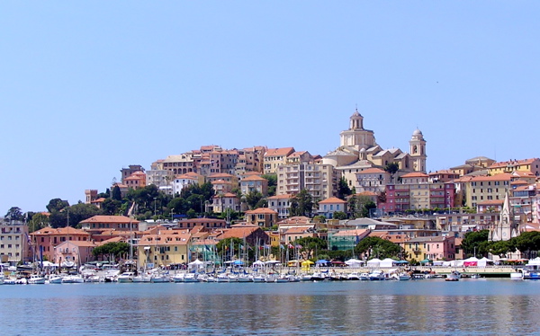

Империя
- коммуна Италии
Hiking in Империя
Imperia, located on the beautiful Italian Riviera in the Liguria region, offers a variety of hiking opportunities that showcase its stunning coastal landscapes, charming villages, and lush countryside. Here are some highlights and tips for hiking in Imperia:...
- Страна:
- Почтовый код: 18100
- Телефонный код: 0183
- Код автомобильного номера: IM
- Координаты: 43° 53' 11" N, 8° 1' 47" E
- GPS треки (wikiloc): [Ссылка]
- Высота над уровнем моря: 10 м m
- Площадь: 45 кв.км
- Население: 41999
- Веб сайт: [Ссылка]
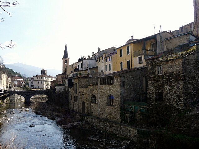

Боргомаро
- коммуна Италии
Hiking in Боргомаро
Borgomaro is a picturesque village located in the Liguria region of Italy, nestled in the foothills of the Maritime Alps. The area offers beautiful hiking opportunities, featuring lush landscapes, charming villages, and stunning views of the surrounding mountains and valleys....
- Страна:
- Почтовый код: 18021
- Телефонный код: 0183
- Код автомобильного номера: IM
- Координаты: 43° 58' 32" N, 7° 56' 41" E
- GPS треки (wikiloc): [Ссылка]
- Высота над уровнем моря: 200 м m
- Площадь: 23.44 кв.км
- Население: 881
- Веб сайт: [Ссылка]


Дольчедо
- коммуна Италии
Hiking in Дольчедо
Dolcedo, a charming village located in the Italian Riviera region of Liguria, offers a great backdrop for hiking enthusiasts. Nestled in a picturesque valley, surrounded by ancient olive groves and Mediterranean vegetation, Dolcedo provides an array of hiking trails that cater to various skill levels....
- Страна:
- Почтовый код: 18020
- Телефонный код: 0183
- Код автомобильного номера: IM
- Координаты: 43° 54' 25" N, 7° 57' 6" E
- GPS треки (wikiloc): [Ссылка]
- Высота над уровнем моря: 75 м m
- Площадь: 19.8 кв.км
- Население: 1385
- Веб сайт: [Ссылка]

Лучинаско
- коммуна Италии
Hiking in Лучинаско
Lucinasco is a charming village located in the province of Imperia in the Liguria region of Italy. Nestled in the hills above the coastline, it offers stunning views of the surrounding landscape, making it an excellent destination for hiking enthusiasts. Here are some key points about hiking in and around Lucinasco:...
- Страна:
- Почтовый код: 18020
- Телефонный код: 0183
- Код автомобильного номера: IM
- Координаты: 43° 58' 4" N, 7° 57' 46" E
- GPS треки (wikiloc): [Ссылка]
- Высота над уровнем моря: 499 м m
- Площадь: 7.9 кв.км
- Население: 283
- Веб сайт: [Ссылка]

Понтедассио
- коммуна Италии
Hiking in Понтедассио
Pontedassio, located in the beautiful Liguria region of Italy, offers a variety of hiking opportunities characterized by scenic landscapes, lush greenery, and breathtaking views of the surrounding hills and valleys. Here are some details to help you plan a hiking adventure in this picturesque area:...
- Страна:
- Почтовый код: 18027
- Телефонный код: 0183
- Код автомобильного номера: IM
- Координаты: 43° 56' 25" N, 8° 0' 44" E
- GPS треки (wikiloc): [Ссылка]
- Высота над уровнем моря: 80 м m
- Площадь: 13.31 кв.км
- Население: 2318
- Веб сайт: [Ссылка]


Прела
- коммуна Италии
Hiking in Прела
Prelà is a charming village located in the Liguria region of Italy, known for its lush landscapes and proximity to the beautiful Italian Riviera. Hiking in and around Prelà offers a range of experiences, from gentle walks through olive groves to more challenging trails with stunning views of the surrounding mountains and coastline....
- Страна:
- Почтовый код: 18020
- Телефонный код: 0183
- Код автомобильного номера: IM
- Координаты: 43° 55' 26" N, 7° 54' 33" E
- GPS треки (wikiloc): [Ссылка]
- Высота над уровнем моря: 151 м m
- Площадь: 14.8 кв.км
- Население: 498
- Веб сайт: [Ссылка]