Pugny-Chatenod (Pugny-Chatenod)

- коммуна во Франции
 Hiking in Pugny-Chatenod
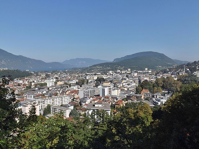
Pugny-Chatenod is a picturesque area located near Chambéry in the Savoie region of France. It's known for its beautiful natural scenery and offers various opportunities for hiking enthusiasts. Here are some highlights and tips for hiking in the Pugny-Chatenod area:
Trails:
-
Lakes and Forests: The region is characterized by beautiful landscapes featuring lakes, forests, and hills. Look out for trails around the nearby Lac de Pugny, where you can enjoy serene views and nature walks.
-
Le Mont Saint Michel: This is another popular hiking spot nearby, where you can enjoy panoramic views of the surroundings. The trails here range from easy to moderate, making it suitable for hikers of various skill levels.
-
Local Trails: There are several marked trails in the vicinity, ranging from short walks to longer treks. Be sure to check local signage for information on trail lengths and difficulty levels.
Flora and Fauna:
- The area is rich in biodiversity, with a mix of deciduous and coniferous forests. Look for local wildlife, including deer, birds, and various plant species that thrive in the region.
Best Time to Visit:
- The best months for hiking in Pugny-Chatenod are typically from late spring to early autumn (May through October) when the weather is mild, and the trails are generally in good condition. Summer can be warm, so carry enough water and sun protection.
Preparation:
- Footwear: Wear comfortable hiking boots or shoes with good traction.
- Gear: Bring along a day pack with water, snacks, a first aid kit, and weather-appropriate clothing.
- Navigation: Carry a map or a GPS device as some trails may not be well-marked.
Additional Activities:
- If time permits, consider exploring the cultural sites in Chambéry, such as its historical buildings and vibrant local markets.
Always check local guidelines and weather conditions before heading out on your hiking adventure. Enjoy your time hiking in Pugny-Chatenod!
- Страна:

- Почтовый код: 73100
- Координаты: 45° 41' 43" N, 5° 57' 15" E


- GPS треки (wikiloc): [Ссылка]
- Площадь: 5.36 кв.км
- Население: 959
- Веб сайт: http://www.pugny-chatenod.fr/
- Википедия английская: wiki(en)
- Википедия национальная: wiki(fr)
- Хранилище Wikidata: Wikidata: Q819853
- Катеория в википедии: [Ссылка]
- код Freebase: [/m/03npgdm]
- код GeoNames: Альт: [6442852]
- номер SIREN: [217302082]
- код BNF: [15274139x]
- код муниципалитета INSEE: 73208
Граничит с регионами:

Экс-ле-Бен
- коммуна во Франции
Hiking in Экс-ле-Бен
Aix-les-Bains, located in the Savoie region of France, is a beautiful town known for its thermal springs and stunning lakeside scenery. It’s an excellent base for hiking enthusiasts, offering a variety of trails set in the picturesque landscapes of the French Alps and around Lake Bourget, the largest natural lake in France....
- Страна:
- Почтовый код: 73100
- Координаты: 45° 41' 19" N, 5° 54' 54" E
- GPS треки (wikiloc): [Ссылка]
- Площадь: 12.62 кв.км
- Население: 29822
- Веб сайт: [Ссылка]


Mouxy
- коммуна во Франции
Hiking in Mouxy
Mouxy is a charming destination in the French Alps, particularly known for its proximity to Annecy and the surrounding natural beauty. Hiking enthusiasts will find a variety of trails that cater to different skill levels, offering stunning views of landscapes, lakes, and mountains....
- Страна:
- Почтовый код: 73100
- Координаты: 45° 40' 55" N, 5° 56' 4" E
- GPS треки (wikiloc): [Ссылка]
- Площадь: 6.28 кв.км
- Население: 2248
- Веб сайт: [Ссылка]


Montcel, Savoie
Hiking in Montcel, Savoie
Montcel, located in the Savoie region of the French Alps, is an excellent destination for hiking enthusiasts. The area offers a variety of trails that cater to different skill levels, making it suitable for both beginners and experienced hikers....
- Страна:
- Почтовый код: 73100
- Координаты: 45° 43' 24" N, 5° 58' 59" E
- GPS треки (wikiloc): [Ссылка]
- Площадь: 15.23 кв.км
- Население: 968
- Веб сайт: [Ссылка]


Trévignin
- коммуна во Франции
Hiking in Trévignin
Trévignin is a picturesque commune located in the Savoie department of the Auvergne-Rhône-Alpes region in southeastern France. It is nestled near the foothills of the French Alps and offers a variety of hiking opportunities, boasting beautiful landscapes, stunning views, and serene natural environments....
- Страна:
- Почтовый код: 73100
- Координаты: 45° 42' 27" N, 5° 57' 23" E
- GPS треки (wikiloc): [Ссылка]
- Площадь: 6.89 кв.км
- Население: 775
- Веб сайт: [Ссылка]


Grésy-sur-Aix
- коммуна во Франции
Hiking in Grésy-sur-Aix
Grésy-sur-Aix is a charming commune located in the Savoie department in the Auvergne-Rhône-Alpes region of southeastern France. Nestled near the foothills of the Alps and close to the shores of Lake Bourget, it offers beautiful landscapes and a variety of outdoor activities, including hiking....
- Страна:
- Почтовый код: 73100
- Координаты: 45° 43' 23" N, 5° 56' 2" E
- GPS треки (wikiloc): [Ссылка]
- Площадь: 12.73 кв.км
- Население: 4512
- Веб сайт: [Ссылка]


Les Déserts
- коммуна во Франции
Hiking in Les Déserts
Les Déserts is a beautiful region in the French Alps, located near the town of Albertville in the Savoie department. This area is known for its stunning landscapes, rich flora and fauna, and several hiking trails that offer a range of difficulties for outdoor enthusiasts....
- Страна:
- Почтовый код: 73230
- Координаты: 45° 37' 17" N, 6° 0' 40" E
- GPS треки (wikiloc): [Ссылка]
- Площадь: 33.59 кв.км
- Население: 758