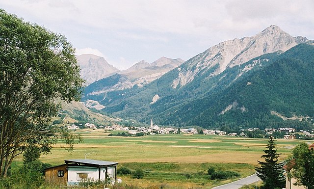
Реаллон (Réallon, Réallon)
- коммуна во Франции
 Hiking in Реаллон
Réallon is a picturesque village located in the French Alps, particularly in the Hautes-Alpes department. It’s a fantastic destination for hiking enthusiasts, offering a mix of stunning landscapes, diverse trails, and breathtaking views of the surrounding mountains and lakes. Here are some key details to consider when hiking in Réallon:
Trails and Routes
- Variety of Trails: There are numerous trails suitable for all levels of hikers, ranging from easy walks to more challenging treks.
- Lac de Réallon: This is a beautiful lake that offers easy trails around its perimeter, perfect for family hikes and enjoying the serene surroundings.
- Balcony Trails: Many trails offer stunning views of the surrounding peaks, including the Écrins National Park. Look for trails that are marked as "balconies," which provide spectacular panoramas.
- Higher Elevations: For more experienced hikers, there are routes leading to higher elevations with rewarding views and the possibility of encountering wildlife.
Best Season for Hiking
- Summer (June to September): This is the best time for hiking in Réallon. The weather is generally warm, and the trails are clear of snow.
- Autumn (September to October): The fall foliage can provide a beautiful backdrop for your hikes, though it’s essential to check weather conditions as temperatures can drop.
Essential Tips
- Weather Preparedness: Always check the local weather forecast before heading out and be prepared for rapid changes in alpine weather.
- Proper Gear: Wear comfortable hiking boots, and consider bringing trekking poles for steep trails. Dress in layers to adjust to temperature changes.
- Navigation: Trails are usually well marked, but having a map or a GPS device can be helpful, especially for more remote trails.
- Hydration and Nutrition: Carry enough water and snacks, especially for longer hikes, to stay energized and hydrated.
Local Resources
- Tourist Information Center: Visit the local tourist office for maps, recommendations, and any guided tours that may be available.
- Guided Tours: If you’re new to hiking or unfamiliar with the area, consider joining a guided tour for a safer and enriched experience.
Safety
- Always let someone know your plans before heading out and consider hiking with a buddy.
- Be mindful of wildlife and maintain a safe distance if you encounter any animals.
Conclusion
Hiking in Réallon offers a unique blend of stunning natural beauty and a range of hiking experiences for all levels. Whether you’re looking for a leisurely walk or a rigorous mountain ascent, Réallon has something to offer. Enjoy your adventures in this beautiful alpine region!
- Страна:

- Почтовый код: 05160
- Координаты: 44° 35' 44" N, 6° 21' 53" E


- GPS треки (wikiloc): [Ссылка]
- Площадь: 71.4 кв.км
- Население: 260
- Веб сайт: http://www.reallon.fr
- Википедия русская: wiki(ru)
- Википедия английская: wiki(en)
- Википедия национальная: wiki(fr)
- Хранилище Wikidata: Wikidata: Q1086638
- Катеория в википедии: [Ссылка]
- код Freebase: [/m/03mfpjr]
- код Freebase: [/m/03mfpjr]
- код GeoNames: Альт: [6425617]
- код GeoNames: Альт: [6425617]
- номер SIREN: [210501144]
- номер SIREN: [210501144]
- WOEID: [618926]
- WOEID: [618926]
- код муниципалитета INSEE: 05114
- код муниципалитета INSEE: 05114
Граничит с регионами:
Ансель
- коммуна во Франции
Hiking in Ансель
Ancelle is a charming village located in the French Alps, specifically in the Hautes-Alpes department. It's a great destination for hiking enthusiasts looking for a mix of natural beauty, alpine scenery, and a variety of trails suitable for different skill levels. Here are some insights into hiking in Ancelle:...
- Страна:
- Почтовый код: 05260
- Координаты: 44° 37' 24" N, 6° 12' 24" E
- GPS треки (wikiloc): [Ссылка]
- Площадь: 50.66 кв.км
- Население: 905
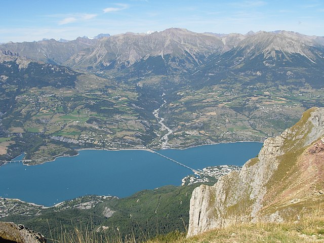
Савин-ле-Лак
- коммуна во Франции
Hiking in Савин-ле-Лак
Savines-le-Lac is a picturesque village located in the French Alps, near the Serre-Ponçon Lake in the Hautes-Alpes region. It's an excellent destination for hiking enthusiasts, offering a variety of trails that cater to different skill levels, with stunning views of the lake and surrounding mountains....
- Страна:
- Почтовый код: 05160
- Координаты: 44° 31' 33" N, 6° 24' 18" E
- GPS треки (wikiloc): [Ссылка]
- Высота над уровнем моря: 790 м m
- Площадь: 25.13 кв.км
- Население: 1063
- Веб сайт: [Ссылка]

Орсьер
- коммуна во Франции
Hiking in Орсьер
Orcières is a stunning destination located in the French Alps, nestled within the Écrins National Park in the Haute-Alpes region. It offers a variety of hiking opportunities suitable for all levels of experience. Here are some key points to consider:...
- Страна:
- Почтовый код: 05170
- Координаты: 44° 41' 4" N, 6° 19' 30" E
- GPS треки (wikiloc): [Ссылка]
- Площадь: 98.27 кв.км
- Население: 715

Прюньер
Hiking in Прюньер
Hiking in Prunières, located in the Hautes-Alpes region of France, offers stunning landscapes and a variety of trails suitable for all levels of hikers. This area is known for its beautiful mountains, alpine meadows, and pristine nature, making it an ideal destination for outdoor enthusiasts....
- Страна:
- Почтовый код: 05230
- Координаты: 44° 32' 31" N, 6° 20' 0" E
- GPS треки (wikiloc): [Ссылка]
- Площадь: 13.2 кв.км
- Население: 298
- Веб сайт: [Ссылка]

Сент-Аполлинер
Hiking in Сент-Аполлинер
Saint-Apollinaire is a charming commune in the Hautes-Alpes department of France, renowned for its stunning natural landscapes and proximity to the French Alps. Hiking in this region offers a variety of trails suitable for different skill levels, providing opportunities to explore diverse terrains, from lush valleys to rocky mountain paths....
- Страна:
- Почтовый код: 05160
- Координаты: 44° 33' 22" N, 6° 21' 44" E
- GPS треки (wikiloc): [Ссылка]
- Площадь: 7.54 кв.км
- Население: 138

Амбрён
- коммуна во Франции
Hiking in Амбрён
Embrun, located in the Hautes-Alpes region of France, is a fantastic destination for hiking enthusiasts. Nestled in the French Alps, the area boasts stunning landscapes, diverse flora and fauna, and a variety of trails suitable for all skill levels....
- Страна:
- Почтовый код: 05200
- Координаты: 44° 33' 54" N, 6° 29' 43" E
- GPS треки (wikiloc): [Ссылка]
- Высота над уровнем моря: 1789 м m
- Площадь: 36.39 кв.км
- Население: 6177
- Веб сайт: [Ссылка]
Шорж
- коммуна во Франции
Hiking in Шорж
Chorges, located in the Hautes-Alpes region of France, is a beautiful destination for hiking enthusiasts. Nestled in the stunning natural environment of the French Alps, it offers a range of trails suitable for all levels of hikers, from beginners to experienced trekkers. Here’s what you need to know about hiking in Chorges:...
- Страна:
- Почтовый код: 05230
- Координаты: 44° 32' 44" N, 6° 16' 35" E
- GPS треки (wikiloc): [Ссылка]
- Высота над уровнем моря: 835 м m
- Площадь: 53.34 кв.км
- Население: 2810
- Веб сайт: [Ссылка]

Шатору-лез-Альп
- коммуна во Франции
Hiking in Шатору-лез-Альп
Châteauroux-les-Alpes is a charming village located in the Hautes-Alpes department in southeastern France. It is surrounded by beautiful mountainous landscapes, making it a great base for hiking enthusiasts. Here are some highlights of hiking in and around Châteauroux-les-Alpes:...
- Страна:
- Почтовый код: 05380
- Координаты: 44° 36' 52" N, 6° 31' 19" E
- GPS треки (wikiloc): [Ссылка]
- Площадь: 92.84 кв.км
- Население: 1146

Пюи-Сент-Эзеб
- коммуна во Франции
Hiking in Пюи-Сент-Эзеб
Puy-Saint-Eusèbe is a charming destination for hiking enthusiasts, nestled in the region of Auvergne-Rhône-Alpes in southeastern France. The area is known for its stunning landscapes, characterized by rolling hills, deep valleys, and picturesque views of the surrounding mountains....
- Страна:
- Почтовый код: 05200
- Координаты: 44° 34' 4" N, 6° 24' 4" E
- GPS треки (wikiloc): [Ссылка]
- Площадь: 11.31 кв.км
- Население: 137