Сент-Аполлинер (Saint-Apollinaire, Saint-Apollinaire)
 Hiking in Сент-Аполлинер
Saint-Apollinaire is a charming commune in the Hautes-Alpes department of France, renowned for its stunning natural landscapes and proximity to the French Alps. Hiking in this region offers a variety of trails suitable for different skill levels, providing opportunities to explore diverse terrains, from lush valleys to rocky mountain paths.
Key Highlights of Hiking in Saint-Apollinaire
-
Scenic Trails: The trails around Saint-Apollinaire are marked and well maintained, leading you through picturesque alpine scenery, with options to hike in both wooded areas and higher altitudes where you can enjoy panoramic views of the surrounding mountains.
-
Accessibility: Many hiking trails in the Hautes-Alpes are easily accessible from the village, making it convenient for both day hikes and longer excursions. You can find routes that cater to families, casual hikers, and more experienced adventurers.
-
Flora and Fauna: The region is rich in biodiversity. While hiking, you may encounter a variety of wildlife, including chamois, marmots, and numerous bird species, as well as diverse alpine flora that blooms throughout the warmer months.
-
Local Culture: Hiking in this region also offers opportunities to experience local culture. You may pass through small villages or farms, where you can learn about traditional Alpine life and perhaps even sample some regional cuisine.
-
Seasonal Variations: Each season offers a unique experience. Summer is great for wildflower viewing, while fall showcases vibrant foliage. Winter may provide options for snowshoeing or ski touring in the higher elevations.
-
Safety and Preparedness: When planning a hike, it's important to check the weather conditions and to be well-prepared with proper gear, sufficient water, and food. Always let someone know your plans, especially if hiking in more remote areas.
Recommended Hikes
- Lac de Puan: A moderate hike that takes you to a beautiful alpine lake, often dotted with wildflowers in summer.
- Col de la Raye: This trail offers a more challenging route with rewarding views from the mountain pass.
- Les Sentiers de la Vallée: A series of well-marked paths suitable for various hiking levels that explore the valley and its surroundings.
Conclusion
Hiking in Saint-Apollinaire, Hautes-Alpes, promises breathtaking views and a peaceful natural environment, making it an ideal destination for both novice and experienced hikers. Whether you're looking for a leisurely stroll or an adventurous trek, the region's trails cater to all.
- Страна:

- Почтовый код: 05160
- Координаты: 44° 33' 22" N, 6° 21' 44" E


- GPS треки (wikiloc): [Ссылка]
- Площадь: 7.54 кв.км
- Население: 138
- Википедия русская: wiki(ru)
- Википедия английская: wiki(en)
- Википедия национальная: wiki(fr)
- Хранилище Wikidata: Wikidata: Q1364238
- Катеория в википедии: [Ссылка]
- код Freebase: [/m/03m81tf]
- код Freebase: [/m/03m81tf]
- код GeoNames: Альт: [6425625]
- код GeoNames: Альт: [6425625]
- номер SIREN: [210501300]
- номер SIREN: [210501300]
- код муниципалитета INSEE: 05130
- код муниципалитета INSEE: 05130
Граничит с регионами:
Савин-ле-Лак
- коммуна во Франции
Hiking in Савин-ле-Лак
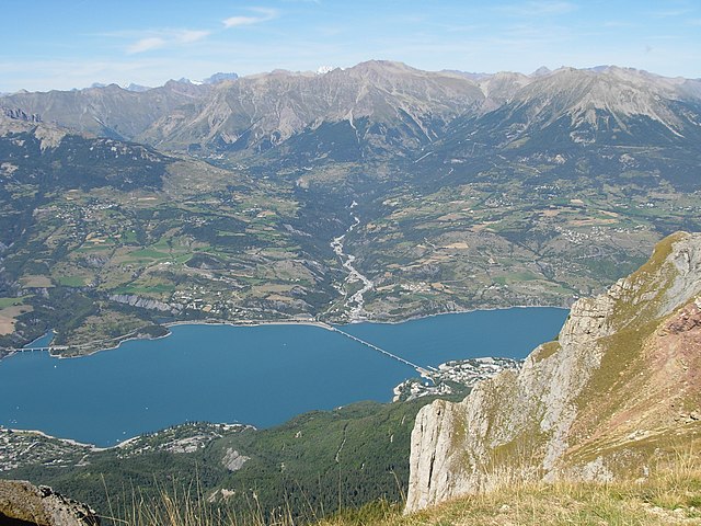
Savines-le-Lac is a picturesque village located in the French Alps, near the Serre-Ponçon Lake in the Hautes-Alpes region. It's an excellent destination for hiking enthusiasts, offering a variety of trails that cater to different skill levels, with stunning views of the lake and surrounding mountains....
- Страна:
- Почтовый код: 05160
- Координаты: 44° 31' 33" N, 6° 24' 18" E
- GPS треки (wikiloc): [Ссылка]
- Высота над уровнем моря: 790 м m
- Площадь: 25.13 кв.км
- Население: 1063
- Веб сайт: [Ссылка]
Реаллон
- коммуна во Франции
Hiking in Реаллон
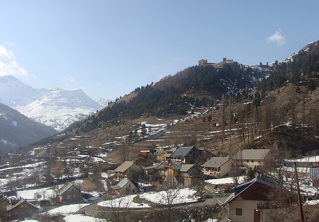
Réallon is a picturesque village located in the French Alps, particularly in the Hautes-Alpes department. It’s a fantastic destination for hiking enthusiasts, offering a mix of stunning landscapes, diverse trails, and breathtaking views of the surrounding mountains and lakes. Here are some key details to consider when hiking in Réallon:...
- Страна:
- Почтовый код: 05160
- Координаты: 44° 35' 44" N, 6° 21' 53" E
- GPS треки (wikiloc): [Ссылка]
- Площадь: 71.4 кв.км
- Население: 260
- Веб сайт: [Ссылка]

Прюньер
Hiking in Прюньер
Hiking in Prunières, located in the Hautes-Alpes region of France, offers stunning landscapes and a variety of trails suitable for all levels of hikers. This area is known for its beautiful mountains, alpine meadows, and pristine nature, making it an ideal destination for outdoor enthusiasts....
- Страна:
- Почтовый код: 05230
- Координаты: 44° 32' 31" N, 6° 20' 0" E
- GPS треки (wikiloc): [Ссылка]
- Площадь: 13.2 кв.км
- Население: 298
- Веб сайт: [Ссылка]