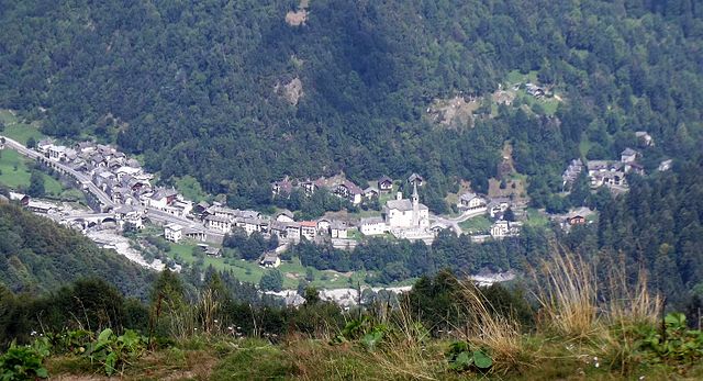
Расса (Rassa, Rassa)
- коммуна Италии
 Hiking in Расса
Rassa, located in the Piedmont region of Italy, is a small village nestled in the Valsesia valley and surrounded by the stunning landscapes of the Sesia Valley Natural Park. This area is known for its picturesque mountains, rich flora and fauna, and the beautiful Sesia River. Hiking in Rassa provides a unique opportunity to explore both natural beauty and cultural heritage.
Hiking Trails
-
Sentiero dei Fiori: This is a relatively easy trail that showcases the diverse wildflowers of the region, particularly during the spring and summer months. It's suitable for families and those looking for a leisurely hike.
-
Monte Pizzo: For those seeking a more challenging hike, the trail to Monte Pizzo offers stunning panoramic views of the surrounding mountains. The ascent can be steep in sections, so proper hiking gear and preparation are essential.
-
Colle di Rassa: This trail connects Rassa to higher altitudes and provides excellent views of the Valsesia valley. It’s a medium-difficulty hike, and along the way, you may encounter local wildlife and rich vegetation.
-
Alpe di Mera: A bit further afield, this hike leads to Alpe di Mera, which is also popular for skiing in the winter. The trail offers beautiful views and is particularly enjoyable in the autumn when the foliage changes color.
Best Time to Hike
The prime time for hiking in Rassa is from late spring (May) to early autumn (October). During these months, the weather is typically mild and the trails are accessible. Autumn offers stunning foliage, while spring boasts blooming wildflowers.
Preparation Tips
- Footwear: Good hiking boots are essential, especially for the more challenging trails.
- Weather: Be prepared for changing weather conditions; layers are advisable.
- Food and Water: Carry enough water and snacks, as some trails may not have facilities.
- Navigation: Maps and local trail guides can be helpful; it's also wise to inform someone of your hiking plans.
Local Culture and Wildlife
While hiking, take time to appreciate the local culture, which may include traditional mountain huts and the opportunity to taste local cuisine. Additionally, you might spot various wildlife, including deer, marmots, and a variety of bird species.
Conclusion
Hiking in Rassa offers a blend of outdoor adventure, stunning natural scenery, and cultural experiences. Whether you're a seasoned hiker or a casual walker, there are trails suitable for all skill levels. Just remember to respect the environment and follow local guidelines during your hikes!
- Страна:

- Почтовый код: 13020
- Телефонный код: 0163
- Код автомобильного номера: VC
- Координаты: 45° 46' 0" N, 8° 1' 0" E


- GPS треки (wikiloc): [Ссылка]
- Высота над уровнем моря: 917 м m
- Площадь: 43.27 кв.км
- Население: 66
- Веб сайт: http://www.rassavalsesia.com
- Википедия русская: wiki(ru)
- Википедия английская: wiki(en)
- Википедия национальная: wiki(it)
- Хранилище Wikidata: Wikidata: Q25183
- Катеория в википедии: [Ссылка]
- код Freebase: [/m/0g8qyl]
- код GeoNames: Альт: [6543414]
- код VIAF: Альт: [236160235]
- ID отношения в OpenStreetMap: [45873]
- код GND: Альт: [7677197-0]
- код ISTAT: 002110
- кадастровый код Италии: H188
Граничит с регионами:

Андорно-Микка
- коммуна Италии
Hiking in Андорно-Микка
Andorno Micca is a charming town situated in the Piedmont region of Italy, specifically in the province of Biella. The area is known for its beautiful natural landscapes, which make it an excellent destination for hiking enthusiasts. Here are some highlights and tips for hiking in Andorno Micca:...
- Страна:
- Почтовый код: 13811
- Телефонный код: 015
- Код автомобильного номера: BI
- Координаты: 45° 36' 0" N, 8° 3' 0" E
- GPS треки (wikiloc): [Ссылка]
- Высота над уровнем моря: 544 м m
- Площадь: 11.89 кв.км
- Население: 3218
- Веб сайт: [Ссылка]

Петтиненго
- коммуна Италии
Hiking in Петтиненго
Pettinengo is a charming village located in the Biella province of the Piedmont region in northern Italy. The area is characterized by its beautiful landscapes, rolling hills, and proximity to the Alps, making it an attractive destination for hikers and outdoor enthusiasts....
- Страна:
- Почтовый код: 13843
- Телефонный код: 015
- Код автомобильного номера: BI
- Координаты: 45° 36' 47" N, 8° 6' 15" E
- GPS треки (wikiloc): [Ссылка]
- Высота над уровнем моря: 703 м m
- Площадь: 15.30 кв.км
- Население: 1556
- Веб сайт: [Ссылка]

Тавильяно
- коммуна Италии
Hiking in Тавильяно
Tavigliano is a charming village in the province of Biella in the Piedmont region of northern Italy, surrounded by stunning natural landscapes that make it an excellent destination for hiking enthusiasts. The area is characterized by its picturesque hills, forests, and meadows, offering a variety of trails suitable for different skill levels....
- Страна:
- Почтовый код: 13811
- Телефонный код: 015
- Код автомобильного номера: BI
- Координаты: 45° 37' 0" N, 8° 3' 0" E
- GPS треки (wikiloc): [Ссылка]
- Высота над уровнем моря: 659 м m
- Площадь: 11.24 кв.км
- Население: 941
- Веб сайт: [Ссылка]

Кампертоньо
- коммуна Италии
Hiking in Кампертоньо
Campertogno is a charming village located in the Valsesia region of Piedmont, Italy, and is surrounded by stunning natural landscapes, making it a great destination for hiking enthusiasts. The area is known for its scenic trails, which range from easier walks suitable for families to more challenging routes for experienced hikers....
- Страна:
- Почтовый код: 13023
- Телефонный код: 0163
- Код автомобильного номера: VC
- Координаты: 45° 48' 0" N, 8° 2' 0" E
- GPS треки (wikiloc): [Ссылка]
- Высота над уровнем моря: 827 м m
- Площадь: 34.14 кв.км
- Население: 241
- Веб сайт: [Ссылка]
Пйоде
- коммуна Италии
Hiking in Пйоде
It seems like there might be a typo in your request, as "Piode" doesn't directly correspond to any well-known hiking destination. If you meant "Piódão," which is a picturesque village in Portugal, or perhaps another location, please clarify. However, if you're referring to hiking around Piódão, here's some general information:...
- Страна:
- Почтовый код: 13020
- Телефонный код: 0163
- Код автомобильного номера: VC
- Координаты: 45° 46' 0" N, 8° 3' 0" E
- GPS треки (wikiloc): [Ссылка]
- Высота над уровнем моря: 752 м m
- Площадь: 13.6 кв.км
- Население: 190
- Веб сайт: [Ссылка]


Габи
- коммуна Италии
Hiking in Габи
Gaby is a charming small village located in the Aosta Valley region of Italy, which is known for its stunning mountainous landscapes, rich history, and outdoor activities, including hiking. Here are some key points to consider when planning a hiking trip in and around Gaby:...
- Страна:
- Почтовый код: 11020
- Телефонный код: 0125
- Код автомобильного номера: AO
- Координаты: 45° 42' 16" N, 7° 53' 2" E
- GPS треки (wikiloc): [Ссылка]
- Высота над уровнем моря: 1047 м m
- Площадь: 32.17 кв.км
- Население: 467
- Веб сайт: [Ссылка]


Грессоне-Сен-Жан
- коммуна Италии
Hiking in Грессоне-Сен-Жан
Gressoney-Saint-Jean, located in the Aosta Valley of Italy, is a beautiful mountain village that offers excellent hiking opportunities in the scenic backdrop of the Alps. The area is particularly known for its stunning landscapes, featuring majestic peaks, lush valleys, and picturesque forests....
- Страна:
- Почтовый код: 11025
- Телефонный код: 0125
- Код автомобильного номера: AO
- Координаты: 45° 47' 0" N, 7° 49' 0" E
- GPS треки (wikiloc): [Ссылка]
- Высота над уровнем моря: 1385 м m
- Площадь: 69.65 кв.км
- Население: 818
- Веб сайт: [Ссылка]