Reugney (Reugney)

- коммуна во Франции
 Hiking in Reugney
Reugney, located in the Vosges department of France, offers a beautiful setting for hiking enthusiasts. The region is characterized by its rolling hills, dense forests, and picturesque landscapes, making it a charming destination for outdoor activities.
Hiking Trails:
-
Local Trails: There are several marked paths within and around Reugney that cater to different skill levels. The trails often lead through scenic woodlands and offer opportunities to see local wildlife.
-
Gorges de la Doux: Close to Reugney, this area features some striking gorges and is great for more adventurous hikes. The terrain can be rugged, perfect for those seeking a challenge.
-
Vosges Mountains: For those willing to venture a bit further, hiking in the Vosges Mountains provides breathtaking views and a variety of trails. Popular routes include the GR5, which runs through the Vosges and offers long-distance hiking opportunities.
Best Practices:
- Choose Appropriate Gear: Make sure to wear sturdy hiking boots and bring weather-appropriate clothing, as weather in the Vosges can change rapidly.
- Stay Hydrated: Carry sufficient water, especially during longer hikes.
- Respect Nature: Stick to marked trails to help preserve the ecosystem.
Local Tips:
- Seek Local Knowledge: Consider reaching out to local hiking clubs or tourist offices for updated maps and recommendations on the best seasonal hikes.
- Wildlife Observation: The area is rich in biodiversity. Bring binoculars if you're interested in birdwatching or observing other wildlife.
- Seasonal Considerations: Spring and autumn are particularly lovely times to hike in this region, with vibrant foliage and milder temperatures.
Whether you're looking for a casual stroll in nature or a more challenging trek, Reugney and its surroundings offer something for every hiking enthusiast. Enjoy your adventures!
- Страна:

- Почтовый код: 25330
- Координаты: 47° 0' 45" N, 6° 9' 5" E


- GPS треки (wikiloc): [Ссылка]
- Площадь: 8.19 кв.км
- Население: 317
- Википедия английская: wiki(en)
- Википедия национальная: wiki(fr)
- Хранилище Wikidata: Wikidata: Q908862
- Катеория в википедии: [Ссылка]
- код Freebase: [/m/03mhcb3]
- код Freebase: [/m/03mhcb3]
- код GeoNames: Альт: [6429958]
- код GeoNames: Альт: [6429958]
- номер SIREN: [212504898]
- номер SIREN: [212504898]
- код BNF: [15252715p]
- код BNF: [15252715p]
- код муниципалитета INSEE: 25489
- код муниципалитета INSEE: 25489
Граничит с регионами:

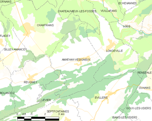
Amathay-Vésigneux
- коммуна во Франции
Hiking in Amathay-Vésigneux
Amathay-Vésigneux is a small commune located in the eastern part of France, in the Auvergne-Rhône-Alpes region. While it may not be as widely recognized as some larger hiking destinations, it offers a unique landscape and opportunities for outdoor enthusiasts....
- Страна:
- Почтовый код: 25330
- Координаты: 47° 1' 25" N, 6° 12' 0" E
- GPS треки (wikiloc): [Ссылка]
- Площадь: 12.13 кв.км
- Население: 160

Chantrans
- коммуна во Франции
Hiking in Chantrans
It seems there might be a slight misunderstanding, as "Chantrans" does not appear to be a well-known hiking destination or location as of my last update in October 2023. It could be a misspelling or a less-recognized area. If you meant a specific national park, region, or trail, please clarify the name or provide more context....
- Страна:
- Почтовый код: 25330
- Координаты: 47° 2' 36" N, 6° 9' 0" E
- GPS треки (wikiloc): [Ссылка]
- Площадь: 14.31 кв.км
- Население: 401


Levier
- коммуна во Франции
Hiking in Levier
Levier is a lesser-known destination for hiking enthusiasts, but it offers a unique experience amidst beautiful landscapes. While specific trails and conditions can vary, here are some general points to consider when hiking in or around Levier:...
- Страна:
- Почтовый код: 25270
- Координаты: 46° 57' 13" N, 6° 7' 7" E
- GPS треки (wikiloc): [Ссылка]
- Площадь: 37.6 кв.км
- Население: 2020
- Веб сайт: [Ссылка]


Bolandoz
- коммуна во Франции
Hiking in Bolandoz
Bolandoz is a small commune located in the Bourgogne-Franche-Comté region of France, known for its natural beauty and charming landscapes. While it may not be as widely recognized as other hiking destinations, it offers various opportunities for exploration and enjoying the great outdoors....
- Страна:
- Почтовый код: 25330
- Координаты: 47° 1' 7" N, 6° 6' 41" E
- GPS треки (wikiloc): [Ссылка]
- Площадь: 12.21 кв.км
- Население: 385

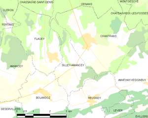
Silley-Amancey
- коммуна во Франции
Hiking in Silley-Amancey
Silley-Amancey is a charming commune located in the Doubs department of the Bourgogne-Franche-Comté region in eastern France. It offers various hiking opportunities that cater to different skill levels, making it a great spot for outdoor enthusiasts....
- Страна:
- Почтовый код: 25330
- Координаты: 47° 1' 55" N, 6° 8' 23" E
- GPS треки (wikiloc): [Ссылка]
- Площадь: 5.16 кв.км
- Население: 131