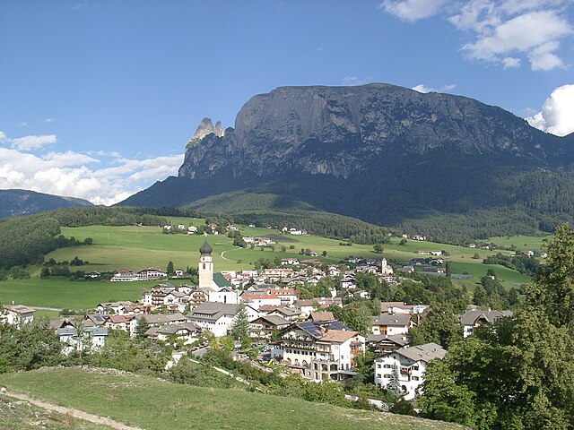
Ренон (Ritten, Renon)
.svg)
- коммуна в Италии
 Hiking in Ренон
Ritten, also known as Renon, is a picturesque area located in South Tyrol, Italy, just outside of Bolzano. It offers a fantastic hiking experience with its stunning landscapes, diverse trails, and panoramic views of the Dolomites. Here are some highlights and tips for hiking in Ritten:
Trails and Routes
-
Ritten High Plateau: The plateau features numerous well-marked trails that cater to various skill levels. You can enjoy easy hikes as well as more challenging routes.
-
Earth Pyramids of Ritten: This unique natural phenomenon can be explored via a trail that leads you to these striking formations. The hike offers both cultural and geological insights.
-
Petersberg to Rittner Horn: For a more challenging hike, consider the trek from Petersberg to Rittner Horn. This trail offers breathtaking views and takes you through rugged terrain.
-
Hiking to the Montiggler Lakes: If you're interested in a more relaxed hike, the trails around Montiggler Lakes provide a lovely setting for a leisurely stroll or picnic, surrounded by the forest.
Tips for Hiking in Ritten
-
Best Time to Hike: Late spring to early autumn (May to October) is typically the best time for hiking, with warm weather and clear views.
-
Gear: Ensure you wear good hiking boots and bring layers, as the weather can change quickly in the mountains. A hydration pack and snacks are also recommended.
-
Maps and Signage: While the trails are generally well-marked, it's a good idea to have a map or a hiking app for navigation.
-
Local Guidance: Consider joining guided hikes if you're unfamiliar with the area. Local guides can offer valuable insights into the region's flora, fauna, and culture.
-
Respect Nature: Follow Leave No Trace principles, stay on marked trails, and always prioritize safety during your hikes.
Ritten's blend of natural beauty, cultural heritage, and well-maintained hiking paths makes it a fantastic destination for both casual hikers and serious outdoor enthusiasts. Enjoy your adventure!
- Страна:

- Почтовый код: 39054
- Телефонный код: 0471
- Код автомобильного номера: BZ
- Координаты: 46° 32' 29" N, 11° 27' 26" E


- GPS треки (wikiloc): [Ссылка]
- Высота над уровнем моря: 1154 м m
- Площадь: 111.36 кв.км
- Население: 7892
- Веб сайт: http://www.comune.renon.bz.it
- Википедия русская: wiki(ru)
- Википедия английская: wiki(en)
- Википедия национальная: wiki(it)
- Хранилище Wikidata: Wikidata: Q474441
- Галерея изображений в википедии: [Ссылка]
- Катеория в википедии: [Ссылка]
- код Freebase: [/m/01b26w]
- код GeoNames: Альт: [6536015]
- код VIAF: Альт: [136261345]
- ID отношения в OpenStreetMap: [47233]
- код GND: Альт: [4050147-4]
- идентификатор местоположения ArchINFORM: [13946]
- код LCNAF: Альт: [n2007003146]
- UN/LOCODE: [ITRN2]
- код ISTAT: 021072
- кадастровый код Италии: H236
Граничит с регионами:


Сарентино
- коммуна в Италии
Hiking in Сарентино
Sarntal, also known as the Sarntal Valley, is a beautiful hiking destination located in South Tyrol, Italy, just north of Bolzano. This area is known for its stunning landscapes, diverse flora and fauna, and rich cultural heritage. Here are some key points to consider when planning a hiking trip in Sarntal:...
- Страна:
- Почтовый код: 39058
- Телефонный код: 0471
- Код автомобильного номера: BZ
- Координаты: 46° 38' 37" N, 11° 21' 22" E
- GPS треки (wikiloc): [Ссылка]
- Высота над уровнем моря: 2781 м m
- Площадь: 302.27 кв.км
- Население: 7058
- Веб сайт: [Ссылка]


Барбьяно
- коммуна Италии
Hiking in Барбьяно
Barbian, located in the South Tyrol region of northern Italy, is a beautiful destination for hiking enthusiasts. Nestled in the scenic Dolomites, Barbian offers a mix of well-marked trails that vary in difficulty, making it suitable for both beginners and experienced hikers....
- Страна:
- Почтовый код: 39040
- Телефонный код: 0471
- Код автомобильного номера: BZ
- Координаты: 46° 36' 12" N, 11° 31' 17" E
- GPS треки (wikiloc): [Ссылка]
- Высота над уровнем моря: 836 м m
- Площадь: 24.51 кв.км
- Население: 1699
- Веб сайт: [Ссылка]


Кастельротто
- коммуна Италии
Hiking in Кастельротто
Kastelruth, located in the beautiful Dolomites region of northern Italy, is a fantastic destination for hiking enthusiasts. The area is known for its stunning landscapes, diverse trails, and charming alpine villages. Here are some highlights and tips for hiking in Kastelruth:...
- Страна:
- Почтовый код: 39040
- Телефонный код: 0471
- Код автомобильного номера: BZ
- Координаты: 46° 34' 0" N, 11° 33' 40" E
- GPS треки (wikiloc): [Ссылка]
- Высота над уровнем моря: 2958 м m
- Площадь: 117.9 кв.км
- Население: 6872
- Веб сайт: [Ссылка]


Корнедо-алл'Изарко
- коммуна Италии
Hiking in Корнедо-алл'Изарко
Karneid, located in South Tyrol, Italy, offers beautiful hiking opportunities amidst stunning mountain landscapes. The region is known for its diverse trails that range from easy walks to challenging treks, making it suitable for hikers of all skill levels....
- Страна:
- Почтовый код: 39053
- Телефонный код: 0471
- Код автомобильного номера: BZ
- Координаты: 46° 30' 0" N, 11° 24' 0" E
- GPS треки (wikiloc): [Ссылка]
- Высота над уровнем моря: 510 м m
- Площадь: 40.61 кв.км
- Население: 3391
- Веб сайт: [Ссылка]

Фие-алло-Шилиар
- коммуна Италии
Hiking in Фие-алло-Шилиар
Völs am Schlern, nestled in the heart of South Tyrol, Italy, is an excellent destination for hiking enthusiasts. Its picturesque landscape features stunning views of the Sciliar massif and lush green valleys, making it a perfect spot for both novice and experienced hikers....
- Страна:
- Почтовый код: 39050
- Телефонный код: 0471
- Код автомобильного номера: BZ
- Координаты: 46° 31' 0" N, 11° 30' 5" E
- GPS треки (wikiloc): [Ссылка]
- Высота над уровнем моря: 880 м m
- Площадь: 43.96 кв.км
- Население: 3595
- Веб сайт: [Ссылка]


Сан-Дженезио-Атезино
- коммуна в Италии
Hiking in Сан-Дженезио-Атезино
Jenesien, or San Genesio in Italian, is a lovely village located on the southern slopes of the Alps, just above the city of Bolzano in South Tyrol, Italy. It's known for its stunning views, rich history, and a plethora of hiking trails that cater to all skill levels. Here are some key highlights and tips if you're considering hiking in Jenesien:...
- Страна:
- Почтовый код: 39050
- Телефонный код: 0471
- Код автомобильного номера: BZ
- Координаты: 46° 32' 5" N, 11° 19' 47" E
- GPS треки (wikiloc): [Ссылка]
- Высота над уровнем моря: 1000 м m
- Площадь: 68.84 кв.км
- Население: 3045
- Веб сайт: [Ссылка]

Вилландро
- коммуна в Италии
Hiking in Вилландро
Villanders, located in South Tyrol, Italy, is a picturesque village that offers a variety of hiking opportunities amidst stunning alpine scenery. Here are some highlights for hiking in this area:...
- Страна:
- Почтовый код: 39043
- Телефонный код: 0472
- Код автомобильного номера: BZ
- Координаты: 46° 37' 51" N, 11° 32' 13" E
- GPS треки (wikiloc): [Ссылка]
- Высота над уровнем моря: 880 м m
- Площадь: 43.95 кв.км
- Население: 1853
- Веб сайт: [Ссылка]


Больцано
- коммуна Италии
Hiking in Больцано
Bolzano, located in the northern part of Italy in the South Tyrol region, offers stunning hiking opportunities amidst the picturesque backdrop of the Dolomites and surrounding mountains. Here are some highlights and tips for hiking in Bolzano:...
- Страна:
- Почтовый код: 39100
- Телефонный код: 0471
- Код автомобильного номера: BZ
- Координаты: 46° 30' 0" N, 11° 21' 0" E
- GPS треки (wikiloc): [Ссылка]
- Высота над уровнем моря: 232 м m
- Площадь: 52.29 кв.км
- Население: 106951
- Веб сайт: [Ссылка]