
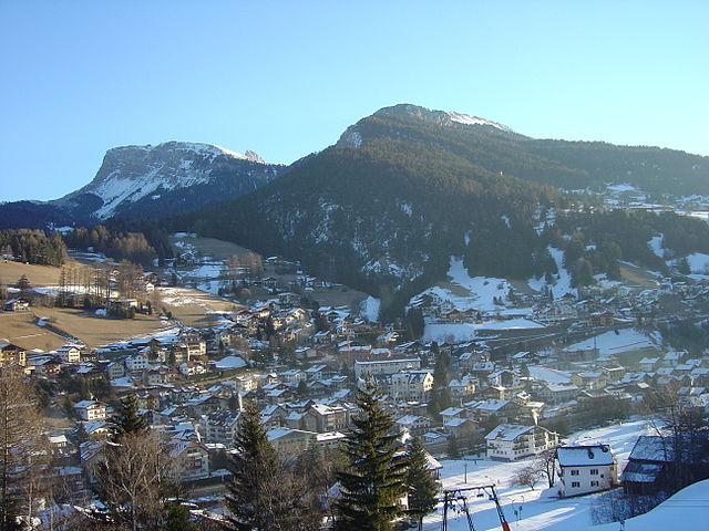
Кастельротто (Kastelruth, Castelrotto)
.svg)
- коммуна Италии
 Hiking in Кастельротто
Kastelruth, located in the beautiful Dolomites region of northern Italy, is a fantastic destination for hiking enthusiasts. The area is known for its stunning landscapes, diverse trails, and charming alpine villages. Here are some highlights and tips for hiking in Kastelruth:
Trails and Routes
-
Seceda: A must-visit area, Seceda offers panoramic views and a variety of trails suitable for all levels. The hike to the peak provides breathtaking vistas of the surrounding Dolomites.
-
Alpe di Siusi: This expansive alpine meadow is one of the largest in Europe and is a favorite hiking spot. Multiple trails wind through the meadows and along the mountains, offering an array of experiences from easy walks to more challenging hikes.
-
Val Gardena: Access to the Val Gardena hiking area provides various paths that connect to the region’s well-marked trail network. Whether you are interested in short hikes or multi-day treks, this area has ample options.
-
The Geisler Group: For those seeking more adventurous routes, the Geisler Group offers the chance to hike among dramatic peaks with varied terrain and challenging trails.
Best Time to Hike
The best months for hiking in Kastelruth are typically late spring through early autumn (May to October). During this time, the weather is generally mild, and trails are accessible. However, always check weather conditions before heading out.
Preparation
- Gear: Wear comfortable hiking boots, and consider moisture-wicking clothing. A good backpack with enough water, snacks, and a first-aid kit is essential.
- Maps and Guides: While many trails are well-marked, carrying a map or using a GPS app can enhance your experience and help prevent getting lost.
- Local Advice: Don’t hesitate to ask locals or stop by the tourist information center for advice on the best trails and current conditions.
Safety
- Always inform someone of your hiking plans and return time.
- Stay on marked trails to protect the delicate alpine environment.
- Be aware of wildlife and the potential for changing weather conditions in alpine areas.
Additional Activities
Beyond hiking, Kastelruth offers various activities such as mountain biking, rock climbing, and cultural experiences, including exploring local cuisine and traditions.
Whether you're a seasoned hiker or a beginner, Kastelruth promises stunning scenery and unforgettable outdoor experiences. Enjoy your hiking adventures!
- Страна:

- Почтовый код: 39040
- Телефонный код: 0471
- Код автомобильного номера: BZ
- Координаты: 46° 34' 0" N, 11° 33' 40" E


- GPS треки (wikiloc): [Ссылка]
- Высота над уровнем моря: 2958 м m
- Площадь: 117.9 кв.км
- Население: 6872
- Веб сайт: http://www.comune.castelrotto.bz.it
- Википедия русская: wiki(ru)
- Википедия английская: wiki(en)
- Википедия национальная: wiki(it)
- Хранилище Wikidata: Wikidata: Q377319
- Галерея изображений в википедии: [Ссылка]
- Катеория в википедии: [Ссылка]
- код Freebase: [/m/0g9g2j]
- код GeoNames: Альт: [6535890]
- код VIAF: Альт: [155950617]
- ID отношения в OpenStreetMap: [47234]
- код GND: Альт: [4110037-2]
- идентификатор местоположения ArchINFORM: [14758]
- код LCNAF: Альт: [n81095132]
- место в MusicBrainz: [519e542d-30cf-4260-9485-c2d61406977e]
- код ISTAT: 021019
- кадастровый код Италии: C254
Граничит с регионами:

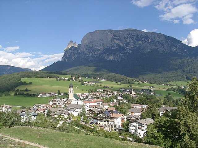
Ортизеи
- коммуна Италии
Hiking in Ортизеи
Urtijëi, also known as Ortisei, is a charming village located in the Val Gardena valley in South Tyrol, Italy. It's a popular base for hiking enthusiasts due to its stunning scenery, diverse trails, and proximity to the Dolomites, a UNESCO World Heritage site. Here are some highlights and tips for hiking in the Urtijëi area:...
- Страна:
- Почтовый код: 39046
- Телефонный код: 0471
- Код автомобильного номера: BZ
- Координаты: 46° 34' 0" N, 11° 40' 0" E
- GPS треки (wikiloc): [Ссылка]
- Высота над уровнем моря: 1230 м m
- Площадь: 24.16 кв.км
- Население: 4883
- Веб сайт: [Ссылка]


Кампителло-ди-Фасса
- коммуна Италии
Hiking in Кампителло-ди-Фасса
Campitello di Fassa, located in the Dolomites in northern Italy, is a picturesque destination for hiking enthusiasts. Surrounded by stunning mountain landscapes, lush forests, and vibrant meadows, it offers a variety of trails suitable for hikers of all skill levels....
- Страна:
- Почтовый код: 38031
- Телефонный код: 0462
- Код автомобильного номера: TN
- Координаты: 46° 28' 36" N, 11° 44' 28" E
- GPS треки (wikiloc): [Ссылка]
- Высота над уровнем моря: 1448 м m
- Площадь: 25.02 кв.км
- Население: 730
- Веб сайт: [Ссылка]


Барбьяно
- коммуна Италии
Hiking in Барбьяно
Barbian, located in the South Tyrol region of northern Italy, is a beautiful destination for hiking enthusiasts. Nestled in the scenic Dolomites, Barbian offers a mix of well-marked trails that vary in difficulty, making it suitable for both beginners and experienced hikers....
- Страна:
- Почтовый код: 39040
- Телефонный код: 0471
- Код автомобильного номера: BZ
- Координаты: 46° 36' 12" N, 11° 31' 17" E
- GPS треки (wikiloc): [Ссылка]
- Высота над уровнем моря: 836 м m
- Площадь: 24.51 кв.км
- Население: 1699
- Веб сайт: [Ссылка]

Фие-алло-Шилиар
- коммуна Италии
Hiking in Фие-алло-Шилиар
Völs am Schlern, nestled in the heart of South Tyrol, Italy, is an excellent destination for hiking enthusiasts. Its picturesque landscape features stunning views of the Sciliar massif and lush green valleys, making it a perfect spot for both novice and experienced hikers....
- Страна:
- Почтовый код: 39050
- Телефонный код: 0471
- Код автомобильного номера: BZ
- Координаты: 46° 31' 0" N, 11° 30' 5" E
- GPS треки (wikiloc): [Ссылка]
- Высота над уровнем моря: 880 м m
- Площадь: 43.96 кв.км
- Население: 3595
- Веб сайт: [Ссылка]


Лайон
- коммуна Италии
Hiking in Лайон
Lajen, or Laion, is a picturesque village located in the South Tyrol region of northern Italy, known for its stunning scenery and outdoor recreational opportunities, including hiking. The area is nestled in the Val Gardena valley, surrounded by the breathtaking Dolomites, a UNESCO World Heritage Site, which offers a wealth of hiking trails for all levels of experience....
- Страна:
- Почтовый код: 39040
- Телефонный код: 0471
- Код автомобильного номера: BZ
- Координаты: 46° 36' 29" N, 11° 33' 56" E
- GPS треки (wikiloc): [Ссылка]
- Высота над уровнем моря: 1093 м m
- Площадь: 37.53 кв.км
- Население: 2675
- Веб сайт: [Ссылка]


Понте-Гардена
- коммуна в Италии
Hiking in Понте-Гардена
Waidbruck, a small village in South Tyrol, Italy, offers some beautiful hiking opportunities, combining stunning alpine scenery with rich cultural experiences. Here are some highlights and tips for hiking in the area:...
- Страна:
- Почтовый код: 39040
- Телефонный код: 0471
- Код автомобильного номера: BZ
- Координаты: 46° 35' 50" N, 11° 31' 51" E
- GPS треки (wikiloc): [Ссылка]
- Высота над уровнем моря: 471 м m
- Площадь: 2.33 кв.км
- Население: 193
- Веб сайт: [Ссылка]


Ренон
- коммуна в Италии
Hiking in Ренон
Ritten, also known as Renon, is a picturesque area located in South Tyrol, Italy, just outside of Bolzano. It offers a fantastic hiking experience with its stunning landscapes, diverse trails, and panoramic views of the Dolomites. Here are some highlights and tips for hiking in Ritten:...
- Страна:
- Почтовый код: 39054
- Телефонный код: 0471
- Код автомобильного номера: BZ
- Координаты: 46° 32' 29" N, 11° 27' 26" E
- GPS треки (wikiloc): [Ссылка]
- Высота над уровнем моря: 1154 м m
- Площадь: 111.36 кв.км
- Население: 7892
- Веб сайт: [Ссылка]


Санта-Кристина-Вальгардена
- коммуна в Италии
Hiking in Санта-Кристина-Вальгардена
Santa Cristina Gherdëina, located in the Dolomites of northern Italy, is a beautiful destination for hiking enthusiasts. The stunning landscape, dramatic peaks, and vibrant alpine scenery provide an incredible backdrop for a variety of hiking trails, suitable for all skill levels. Here are some highlights and tips if you’re considering hiking in this region:...
- Страна:
- Почтовый код: 39047
- Телефонный код: 0471
- Код автомобильного номера: BZ
- Координаты: 46° 33' 47" N, 11° 43' 56" E
- GPS треки (wikiloc): [Ссылка]
- Высота над уровнем моря: 1428 м m
- Площадь: 31.92 кв.км
- Население: 1961
- Веб сайт: [Ссылка]
Тирес
- коммуна в Италии
Hiking in Тирес
Tiers (or Tires) is a charming village located in the Dolomites of South Tyrol, Italy, and offers an abundance of hiking opportunities. Here are some highlights about hiking in that area:...
- Страна:
- Почтовый код: 39050
- Телефонный код: 0471
- Код автомобильного номера: BZ
- Координаты: 46° 28' 5" N, 11° 31' 37" E
- GPS треки (wikiloc): [Ссылка]
- Высота над уровнем моря: 1028 м m
- Площадь: 42.18 кв.км
- Население: 987
- Веб сайт: [Ссылка]


Bedigliora
Hiking in Bedigliora
Bedigliora is a charming village located in the canton of Ticino in Switzerland. It offers beautiful landscapes, serene environments, and a variety of hiking opportunities. Here are some highlights about hiking in and around Bedigliora:...
- Страна:

- Почтовый код: 6981
- Телефонный код: 091
- Код автомобильного номера: TI
- Координаты: 46° 0' 0" N, 8° 51' 0" E
- GPS треки (wikiloc): [Ссылка]
- Высота над уровнем моря: 617 м m
- Площадь: 2.5 кв.км
- Население: 634
- Веб сайт: [Ссылка]