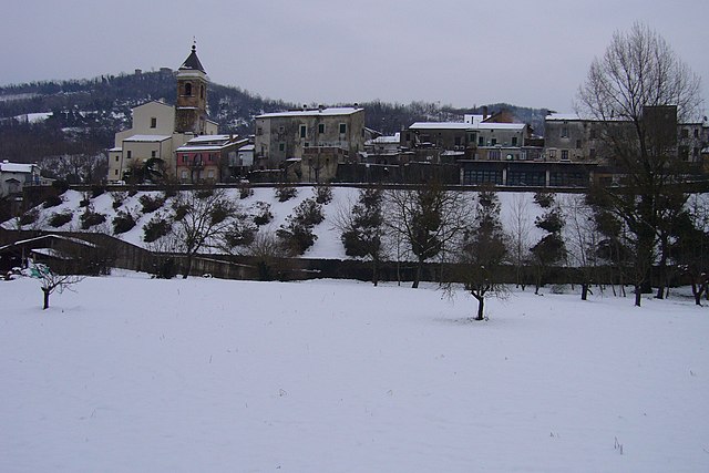
Роккамонтепьяно (Roccamontepiano, Roccamontepiano)
.svg)
- коммуна Италии
 Hiking in Роккамонтепьяно
Roccamontepiano is a charming small town located in the beautiful Abruzzo region of Italy, surrounded by stunning natural landscapes, making it a great destination for hiking enthusiasts. Here are some details about hiking in and around Roccamontepiano:
Scenic Trails
-
Monte Morrone: This mountain offers various trails with different difficulty levels. The panoramic views from the summit are breathtaking, showcasing the surrounding mountains and valleys.
-
Parco Nazionale della Maiella: Located nearby, this national park is abundant in hiking opportunities. The park is known for its rugged mountain terrain, deep gorges, and unique flora and fauna. Trails can vary from easy walks to more challenging hikes.
-
Local Paths: There are numerous well-marked paths around Roccamontepiano, perfect for those looking to explore the countryside and enjoy the local scenery. These trails often take you through fields, forests, and quaint villages.
Tips for Hiking in Roccamontepiano
-
Seasonal Considerations: The best time for hiking in this region is in the spring and fall when the temperatures are milder and the scenery is particularly beautiful. Summers can be hot, while winters may bring snow to higher elevations.
-
Preparation: Make sure to wear appropriate hiking shoes and clothing, and bring enough water, snacks, and a map or GPS device. Cell service may be limited in remote areas.
-
Guided Tours: For those unfamiliar with the area, consider joining guided hikes, which can provide insight into the local flora, fauna, and culture.
-
Respect Nature: Always follow the Leave No Trace principles to protect the environment and preserve the beauty of the trails for future hikers.
Local Culture
Roccamontepiano is not just about hiking; it also offers rich cultural experiences. After a day on the trails, you can enjoy local cuisine that features traditional Abruzzese dishes, and there may be opportunities to explore local festivals and crafts.
Whether you're an experienced hiker or a casual walker, Roccamontepiano has a lot to offer for those looking to immerse themselves in nature and enjoy the serenity of the Abruzzo landscape. Happy hiking!
- Страна:

- Почтовый код: 66010
- Телефонный код: 0871
- Код автомобильного номера: CH
- Координаты: 42° 14' 41" N, 14° 7' 38" E


- GPS треки (wikiloc): [Ссылка]
- Высота над уровнем моря: 500 м m
- Площадь: 18.22 кв.км
- Население: 1671
- Веб сайт: http://www.comune.roccamontepiano.ch.it
- Википедия русская: wiki(ru)
- Википедия английская: wiki(en)
- Википедия национальная: wiki(it)
- Хранилище Wikidata: Wikidata: Q51274
- Катеория в википедии: [Ссылка]
- код Freebase: [/m/0fg3k9]
- код GeoNames: Альт: [6536400]
- код VIAF: Альт: [146783814]
- ID отношения в OpenStreetMap: [41884]
- UN/LOCODE: [ITRMP]
- dmoz: Альт: [Regional/Europe/Italy/Abruzzo/Localities/Roccamontepiano/]
- код ISTAT: 069073
- кадастровый код Италии: H424
Граничит с регионами:


Буккианико
- коммуна Италии
Hiking in Буккианико
Bucchianico is a charming town located in the Abruzzo region of Italy, known for its picturesque landscapes and historical significance. The surrounding area offers various hiking opportunities that cater to different levels of experience. Here are some highlights for hiking in and around Bucchianico:...
- Страна:
- Почтовый код: 66011
- Телефонный код: 0871
- Код автомобильного номера: CH
- Координаты: 42° 18' 16" N, 14° 10' 50" E
- GPS треки (wikiloc): [Ссылка]
- Высота над уровнем моря: 360 м m
- Площадь: 38.08 кв.км
- Население: 5126
- Веб сайт: [Ссылка]
Казалинконтрада
- коммуна Италии
Hiking in Казалинконтрада
Casalincontrada, nestled in the Abruzzo region of Italy, offers a serene hiking experience surrounded by beautiful landscapes and rich biodiversity. The area features rolling hills, picturesque valleys, and a variety of trails suited for different skill levels. Here’s what you should know about hiking in Casalincontrada:...
- Страна:
- Почтовый код: 66012
- Телефонный код: 0871
- Код автомобильного номера: CH
- Координаты: 42° 18' 0" N, 14° 8' 0" E
- GPS треки (wikiloc): [Ссылка]
- Высота над уровнем моря: 333 м m
- Площадь: 16 кв.км
- Население: 3047
- Веб сайт: [Ссылка]

Фара-Фильорум-Петри
- коммуна Италии
Hiking in Фара-Фильорум-Петри
Fara Filiorum Petri is a charming village located in the Abruzzo region of Italy, known for its picturesque landscapes and rich natural beauty. Hiking in and around Fara Filiorum Petri offers a range of trails that cater to different skill levels, allowing hikers to experience the stunning scenery typical of the Apennine Mountains....
- Страна:
- Почтовый код: 66010
- Телефонный код: 0871
- Код автомобильного номера: CH
- Координаты: 42° 14' 54" N, 14° 11' 9" E
- GPS треки (wikiloc): [Ссылка]
- Высота над уровнем моря: 227 м m
- Площадь: 14.96 кв.км
- Население: 1986
- Веб сайт: [Ссылка]


Преторо
- коммуна Италии
Hiking in Преторо
Pretoro is a picturesque village located in the Abruzzo region of Italy, known for its stunning landscapes and outdoor recreational opportunities. Nestled in the Majella National Park, it offers a range of hiking trails that cater to various skill levels, making it a great destination for both novice and experienced hikers....
- Страна:
- Почтовый код: 66010
- Телефонный код: 0871
- Код автомобильного номера: CH
- Координаты: 42° 12' 59" N, 14° 8' 35" E
- GPS треки (wikiloc): [Ссылка]
- Высота над уровнем моря: 560 м m
- Площадь: 26.13 кв.км
- Население: 965
- Веб сайт: [Ссылка]


Серрамоначеска
- коммуна Италии
Hiking in Серрамоначеска
Serramonacesca is a picturesque area located in the Abruzzo region of Italy, surrounded by beautiful mountains and lush landscapes, making it an excellent destination for hiking and outdoor activities. Here are some highlights of hiking in Serramonacesca:...
- Страна:
- Почтовый код: 65025
- Телефонный код: 085
- Код автомобильного номера: PE
- Координаты: 42° 14' 55" N, 14° 5' 36" E
- GPS треки (wikiloc): [Ссылка]
- Высота над уровнем моря: 280 м m
- Площадь: 23.89 кв.км
- Население: 552
- Веб сайт: [Ссылка]