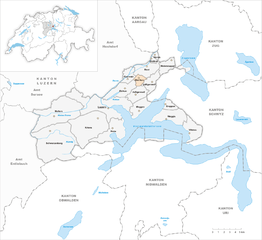
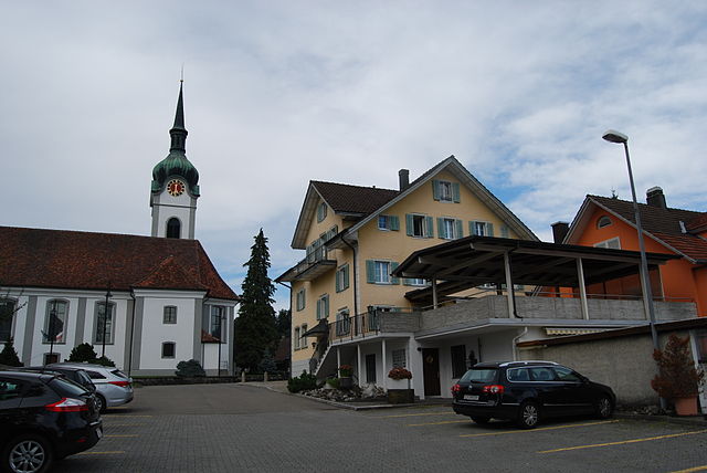
Рот (Root, Root)

- община швейцарии в Швейцарии, Люцерн
 Hiking in Рот
Root, Switzerland, is located in the canton of Luzern and offers beautiful hiking opportunities, characterized by scenic views, lush landscapes, and a variety of trails suitable for different skill levels. Here are some highlights for hiking in and around Root:
Trails and Routes
-
Rooterberg: This area features a range of trails with varying difficulty levels. The paths often offer breathtaking views of the surrounding mountains and Lake Lucerne.
-
Wilderweg: A lovely trail that meanders through forests and meadows, perfect for those looking for a more leisurely hike.
-
Nearby Hiking Areas: Root is also a great base for exploring nearby regions like the Pilatus and Rigi mountains, which have extensive hiking networks.
Accessibility
Root is conveniently located with access to public transport, making it easy to reach starting points for hikes. You can reach it by train or bus from Luzern, which is just a short distance away.
Best Time to Hike
- Spring and Summer: Ideal for vibrant flora and milder weather.
- Autumn: Offers stunning fall colors and cooler temperatures.
- Winter: Certain trails are suitable for snowshoeing or winter hiking, depending on conditions.
Tips for Hiking in Root
- Weather: Always check the weather forecast before heading out, as conditions can change rapidly in the mountains.
- Equipment: Wear appropriate footwear, bring water, snacks, and sunscreen, especially during sunny days.
- Navigation: Although trails are marked, having a map or GPS can be handy.
Local Attractions
After hiking, consider visiting the nearby town of Lucerne for its beautiful architecture, Lake Lucerne, or the famous Chapel Bridge.
Conclusion
Hiking in Root offers an excellent opportunity to explore the natural beauty of Switzerland. Whether you’re a seasoned hiker or a beginner, you’ll find paths that suit your preferences, coupled with stunning topography and fresh mountain air. Enjoy your adventure!
- Страна:

- Почтовый код: 6037
- Телефонный код: 041
- Код автомобильного номера: LU
- Координаты: 47° 6' 57" N, 8° 23' 29" E


- GPS треки (wikiloc): [Ссылка]
- Высота над уровнем моря: 422 м m
- Площадь: 8.65 кв.км
- Население: 4995
- Веб сайт: http://www.gemeinde-root.ch
- Википедия русская: wiki(ru)
- Википедия английская: wiki(en)
- Википедия национальная: wiki(de)
- Хранилище Wikidata: Wikidata: Q14575
- Катеория в википедии: [Ссылка]
- код Freebase: [/m/05rf5r]
- код GeoNames: Альт: [7286947]
- код VIAF: Альт: [233885855]
- ID отношения в OpenStreetMap: [1682912]
- место в MusicBrainz: [d7c9c735-21f5-4ff4-b1d8-1ceb4aafbb51]
- идентификатор HDS: [628]
- код швейцарского муниципалитета: [1065]
Граничит с регионами:

Дирикон
Hiking in Дирикон
Dierikon is a small community located in the canton of Lucerne in Switzerland, surrounded by beautiful natural scenery, making it an excellent destination for hiking enthusiasts. Here are some things you can expect when hiking in and around Dierikon:...
- Страна:
- Почтовый код: 6036
- Телефонный код: 041
- Код автомобильного номера: LU
- Координаты: 47° 5' 49" N, 8° 22' 17" E
- GPS треки (wikiloc): [Ссылка]
- Высота над уровнем моря: 429 м m
- Площадь: 2.78 кв.км
- Население: 1503
- Веб сайт: [Ссылка]


Гизикон
Hiking in Гизикон
Gisikon is a charming village located in Switzerland, known for its beautiful landscapes and proximity to both nature and urban areas. Hiking in and around Gisikon offers a unique blend of scenic views, diverse trails, and opportunities to experience the local Swiss culture....
- Страна:
- Почтовый код: 6038
- Телефонный код: 041
- Код автомобильного номера: LU
- Координаты: 47° 7' 26" N, 8° 23' 53" E
- GPS треки (wikiloc): [Ссылка]
- Высота над уровнем моря: 418 м m
- Площадь: 1.08 кв.км
- Население: 1331
- Веб сайт: [Ссылка]
Хонау
Hiking in Хонау
Honau, Switzerland, is a charming village nestled in the beautiful landscape of the Swiss Alps. While it might not be as widely known as some of the larger Swiss hiking destinations, it offers a variety of scenic trails and outdoor activities that cater to various skill levels....
- Страна:
- Почтовый код: 6038
- Телефонный код: 041
- Код автомобильного номера: LU
- Координаты: 47° 7' 59" N, 8° 24' 22" E
- GPS треки (wikiloc): [Ссылка]
- Высота над уровнем моря: 445 м m
- Площадь: 1.25 кв.км
- Население: 391
- Веб сайт: [Ссылка]


Удлигенсвиль
Hiking in Удлигенсвиль
Udligenswil is a charming municipality located in the canton of Lucerne, Switzerland, surrounded by beautiful landscapes and scenic views. Hiking in this region can be a delightful experience, as it offers a mix of easy walks and more challenging trails suitable for various skill levels....
- Страна:
- Почтовый код: 6044
- Телефонный код: 041
- Код автомобильного номера: LU
- Координаты: 47° 5' 28" N, 8° 23' 59" E
- GPS треки (wikiloc): [Ссылка]
- Высота над уровнем моря: 624 м m
- Площадь: 6.25 кв.км
- Население: 2279
- Веб сайт: [Ссылка]

Инвиль
Hiking in Инвиль
Inwil, a charming municipality located in the canton of Lucerne in Switzerland, offers various opportunities for hiking enthusiasts. Nestled in the picturesque surroundings of central Switzerland, it's a great starting point for exploring the beautiful landscapes of the region....
- Страна:
- Почтовый код: 6034
- Телефонный код: 041
- Код автомобильного номера: LU
- Координаты: 47° 7' 44" N, 8° 22' 6" E
- GPS треки (wikiloc): [Ссылка]
- Высота над уровнем моря: 515 м m
- Площадь: 10.32 кв.км
- Население: 2557
- Веб сайт: [Ссылка]
Бухрайн
Hiking in Бухрайн
Buchrain, located in the Canton of Lucerne in Switzerland, offers a variety of hiking opportunities set against the backdrop of beautiful Swiss landscapes. The area is characterized by picturesque hills, lush forests, and stunning views of surrounding mountains and Lake Lucerne. Here are some key points to consider if you're planning to hike in Buchrain:...
- Страна:
- Почтовый код: 6033
- Телефонный код: 041
- Код автомобильного номера: LU
- Координаты: 47° 5' 43" N, 8° 20' 51" E
- GPS треки (wikiloc): [Ссылка]
- Высота над уровнем моря: 458 м m
- Площадь: 4.80 кв.км
- Население: 6116
- Веб сайт: [Ссылка]