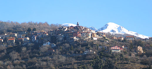
Рокбийер (Roquebillière, Roquebillière)
- коммуна в департаменте Приморские Альпы, регион Прованс — Альпы — Лазурный Берег, Франция
 Hiking in Рокбийер
Roquebillière is a charming village located in the Alpes-Maritimes department of the French Riviera, situated at the foot of the impressive Mercantour National Park. Hiking in and around Roquebillière offers a variety of trails with stunning views, diverse landscapes, and opportunities to encounter local flora and fauna.
Hiking Trails:
-
Mercantour National Park: As Roquebillière is close to this park, you can access numerous hiking trails that take you through rugged mountains, lush valleys, and glacial lakes. Trails vary in difficulty, from easy walks to challenging climbs.
-
La Vésubie Valley: This area provides several scenic trails along the Vésubie River. The trails here often feature picturesque landscapes, waterfalls, and ample spots for picnicking.
-
Mont Bégo: This majestic mountain offers a more strenuous hiking experience. The trail to Mont Bégo leads hikers through stunning alpine scenery with ancient rock engravings along the way.
What to Expect:
- Scenic Views: Hikers can enjoy breathtaking views of the mountains, valleys, and the unique rock formations of the region.
- Wildlife: The area is rich in biodiversity, so keep an eye out for wildlife, including chamois, marmots, and a variety of bird species.
- Flora: The local flora changes with elevation, showcasing beautiful wildflowers, aromatic herbs, and ancient forests.
Recommendations:
- Best Time to Hike: Spring and fall are ideal for hiking, as the weather is mild, and the trails aren’t crowded. Summer can be hot, while winter activities are primarily for skiing.
- Gear: Wear proper hiking boots, and bring layers, as temperatures can vary. A good backpack, water, snacks, and a map or GPS are also essential.
- Safety: Always inform someone of your hiking plans and be respectful of nature, following Leave No Trace guidelines.
Before heading out, check local weather conditions and trail availability, as some may be subject to seasonal closures or conditions. Enjoy your hiking adventures in Roquebillière!
- Страна:

- Почтовый код: 06450
- Координаты: 44° 0' 40" N, 7° 18' 25" E


- GPS треки (wikiloc): [Ссылка]
- Площадь: 25.92 кв.км
- Население: 1802
- Веб сайт: http://www.roquebilliere.com
- Википедия русская: wiki(ru)
- Википедия английская: wiki(en)
- Википедия национальная: wiki(fr)
- Хранилище Wikidata: Wikidata: Q273431
- Галерея изображений в википедии: [Ссылка]
- Катеория в википедии: [Ссылка]
- номер SIREN: [210601035]
- номер SIREN: [210601035]
- код VIAF: Альт: [236151162]
- код VIAF: Альт: [236151162]
- WOEID: [619943]
- WOEID: [619943]
- код муниципалитета INSEE: 06103
- код муниципалитета INSEE: 06103
Граничит с регионами:

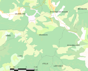
Венансон
- коммуна в департаменте Приморские Альпы, регион Прованс — Альпы — Лазурный Берег, Франция
Hiking in Венансон
Venanson is a charming village located in the Alpes-Maritimes region of France, nestled in the heart of the Mercantour National Park. It offers breathtaking landscapes and a variety of hiking trails that cater to different skill levels. Here are some highlights for hiking in Venanson:...
- Страна:
- Почтовый код: 06450
- Координаты: 44° 3' 11" N, 7° 15' 11" E
- GPS треки (wikiloc): [Ссылка]
- Площадь: 17.98 кв.км
- Население: 155
- Веб сайт: [Ссылка]


Ла-Боллен-Везюби
- коммуна в департаменте Приморские Альпы, регион Прованс — Альпы — Лазурный Берег, Франция
Hiking in Ла-Боллен-Везюби
La Bollène-Vésubie is a charming village located in the Alpes-Maritimes department in the Provence-Alpes-Côte d'Azur region of France. It offers access to beautiful hiking trails that showcase the stunning landscapes of the French Alps. Here are some highlights for hikers considering this area:...
- Страна:
- Почтовый код: 06450
- Координаты: 43° 59' 23" N, 7° 19' 51" E
- GPS треки (wikiloc): [Ссылка]
- Площадь: 35.57 кв.км
- Население: 567
- Веб сайт: [Ссылка]


Сен-Мартен-Везюби
- коммуна в департаменте Приморские Альпы, регион Прованс — Альпы — Лазурный Берег, Франция
Hiking in Сен-Мартен-Везюби
Saint-Martin-Vésubie is a picturesque village located in the Alpes-Maritimes department in the Provence-Alpes-Côte d'Azur region of France. It serves as an excellent base for hiking enthusiasts due to its proximity to the Mercantour National Park and stunning alpine landscapes. Here are some key highlights about hiking in this area:...
- Страна:
- Почтовый код: 06450
- Координаты: 44° 4' 6" N, 7° 15' 21" E
- GPS треки (wikiloc): [Ссылка]
- Площадь: 97.13 кв.км
- Население: 1394
- Веб сайт: [Ссылка]


Лантоск
- коммуна в департаменте Приморские Альпы, регион Прованс — Альпы — Лазурный Берег, Франция
Hiking in Лантоск
Lantosque is a charming commune located in the Alpes-Maritimes department in the Provence-Alpes-Côte d'Azur region of southeastern France. It offers a range of hiking opportunities set against the stunning backdrop of the French Alps and the nearby Mercantour National Park....
- Страна:
- Почтовый код: 06450
- Координаты: 43° 58' 24" N, 7° 18' 45" E
- GPS треки (wikiloc): [Ссылка]
- Площадь: 44.76 кв.км
- Население: 1314
- Веб сайт: [Ссылка]
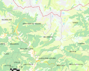
Бельведер
- коммуна в департаменте Приморские Альпы, регион Прованс — Альпы — Лазурный Берег, Франция
Hiking in Бельведер
Belvédère is a beautiful hiking destination that is often characterized by stunning views and diverse landscapes. Although the specifics can depend on which "Belvédère" you are referring to, as the name can be found in different locations around the world, I'll provide an overview of what you typically might expect when hiking in areas known by this name....
- Страна:
- Почтовый код: 06450
- Координаты: 44° 0' 53" N, 7° 19' 16" E
- GPS треки (wikiloc): [Ссылка]
- Площадь: 75.41 кв.км
- Население: 660