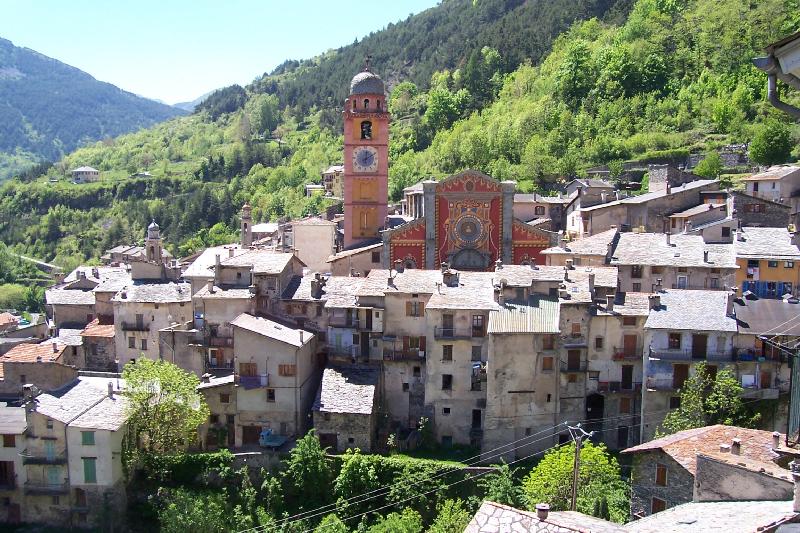
Бельведер (Belvédère, Belvédère)

- коммуна в департаменте Приморские Альпы, регион Прованс — Альпы — Лазурный Берег, Франция
 Hiking in Бельведер
Belvédère is a beautiful hiking destination that is often characterized by stunning views and diverse landscapes. Although the specifics can depend on which "Belvédère" you are referring to, as the name can be found in different locations around the world, I'll provide an overview of what you typically might expect when hiking in areas known by this name.
General Features of Hiking in Belvédère Areas:
-
Scenic Views: The term "Belvédère" means "viewpoint" in French, indicating that hikes in these areas often feature panoramic views of surrounding landscapes, whether they are mountains, valleys, lakes, or other natural attractions.
-
Variety of Trails: Hiking trails in Belvédère regions usually cater to various skill levels, from easy walks suitable for families to more challenging hikes designed for experienced trekkers. It's important to check trail difficulty and length beforehand.
-
Natural Beauty: Expect diverse flora and fauna, as well as unique geological formations. The routes may take you through forests, along rivers, or up steep terrain leading to breathtaking viewpoints.
-
Wildlife Watching: Depending on the region, you might have opportunities to observe local wildlife, so keep your eyes peeled for birds, mammals, and other creatures.
-
Best Time to Visit: Spring and fall are often the prime times for hiking in mountainous or wooded areas, as you can enjoy comfortable temperatures and beautiful seasonal colors. Summers may be hot, while winters might be suited for snowshoeing or cross-country skiing if applicable.
-
Preparation: Always start your hike with proper gear, including sturdy hiking boots, appropriate clothing, navigation tools, sufficient water, and snacks. Inform someone about your hiking plans beforehand and consider hiking with a buddy for safety.
-
Local Regulations: Be mindful of local regulations regarding trail use and wildlife. Leave no trace and ensure that you respect nature by sticking to marked trails.
If you can specify which Belvédère you are referencing (for example, a particular national park or region), I can provide more detailed information about that specific hiking destination!
- Страна:

- Почтовый код: 06450
- Координаты: 44° 0' 53" N, 7° 19' 16" E


- GPS треки (wikiloc): [Ссылка]
- Площадь: 75.41 кв.км
- Население: 660
- Википедия русская: wiki(ru)
- Википедия английская: wiki(en)
- Википедия национальная: wiki(fr)
- Хранилище Wikidata: Wikidata: Q742848
- Катеория в википедии: [Ссылка]
- код GeoNames: Альт: [6446672]
- код GeoNames: Альт: [6446672]
- номер SIREN: [210600136]
- номер SIREN: [210600136]
- код муниципалитета INSEE: 06013
- код муниципалитета INSEE: 06013
Граничит с регионами:

Энтраккуе
- коммуна Италии
Hiking in Энтраккуе
Entracque is a picturesque village located in the Piedmont region of Italy, nestled in the stunning Maritime Alps. It's an excellent destination for hiking enthusiasts, offering a range of trails that cater to various skill levels, from beginners to advanced hikers. Here are some highlights of hiking in Entracque:...
- Страна:

- Почтовый код: 12010
- Телефонный код: 0171
- Код автомобильного номера: CN
- Координаты: 44° 14' 33" N, 7° 24' 0" E
- GPS треки (wikiloc): [Ссылка]
- Высота над уровнем моря: 894 м m
- Площадь: 160.73 кв.км
- Население: 848
- Веб сайт: [Ссылка]

Тенд
- коммуна в департаменте Приморские Альпы, регион Прованс — Альпы — Лазурный Берег, Франция
Hiking in Тенд
Tende is a picturesque commune located in the Alpes-Maritimes department in the Provence-Alpes-Côte d'Azur region of southeastern France. Nestled in the Maritime Alps, it's an excellent destination for hiking enthusiasts, offering stunning landscapes, varied terrains, and rich natural and cultural heritage....
- Страна:
- Почтовый код: 06430
- Координаты: 44° 5' 16" N, 7° 35' 37" E
- GPS треки (wikiloc): [Ссылка]
- Высота над уровнем моря: 816 м m
- Площадь: 177.47 кв.км
- Население: 2174
- Веб сайт: [Ссылка]

Рокбийер
- коммуна в департаменте Приморские Альпы, регион Прованс — Альпы — Лазурный Берег, Франция
Hiking in Рокбийер
Roquebillière is a charming village located in the Alpes-Maritimes department of the French Riviera, situated at the foot of the impressive Mercantour National Park. Hiking in and around Roquebillière offers a variety of trails with stunning views, diverse landscapes, and opportunities to encounter local flora and fauna....
- Страна:
- Почтовый код: 06450
- Координаты: 44° 0' 40" N, 7° 18' 25" E
- GPS треки (wikiloc): [Ссылка]
- Площадь: 25.92 кв.км
- Население: 1802
- Веб сайт: [Ссылка]


Ла-Боллен-Везюби
- коммуна в департаменте Приморские Альпы, регион Прованс — Альпы — Лазурный Берег, Франция
Hiking in Ла-Боллен-Везюби
La Bollène-Vésubie is a charming village located in the Alpes-Maritimes department in the Provence-Alpes-Côte d'Azur region of France. It offers access to beautiful hiking trails that showcase the stunning landscapes of the French Alps. Here are some highlights for hikers considering this area:...
- Страна:
- Почтовый код: 06450
- Координаты: 43° 59' 23" N, 7° 19' 51" E
- GPS треки (wikiloc): [Ссылка]
- Площадь: 35.57 кв.км
- Население: 567
- Веб сайт: [Ссылка]


Сен-Мартен-Везюби
- коммуна в департаменте Приморские Альпы, регион Прованс — Альпы — Лазурный Берег, Франция
Hiking in Сен-Мартен-Везюби
Saint-Martin-Vésubie is a picturesque village located in the Alpes-Maritimes department in the Provence-Alpes-Côte d'Azur region of France. It serves as an excellent base for hiking enthusiasts due to its proximity to the Mercantour National Park and stunning alpine landscapes. Here are some key highlights about hiking in this area:...
- Страна:
- Почтовый код: 06450
- Координаты: 44° 4' 6" N, 7° 15' 21" E
- GPS треки (wikiloc): [Ссылка]
- Площадь: 97.13 кв.км
- Население: 1394
- Веб сайт: [Ссылка]
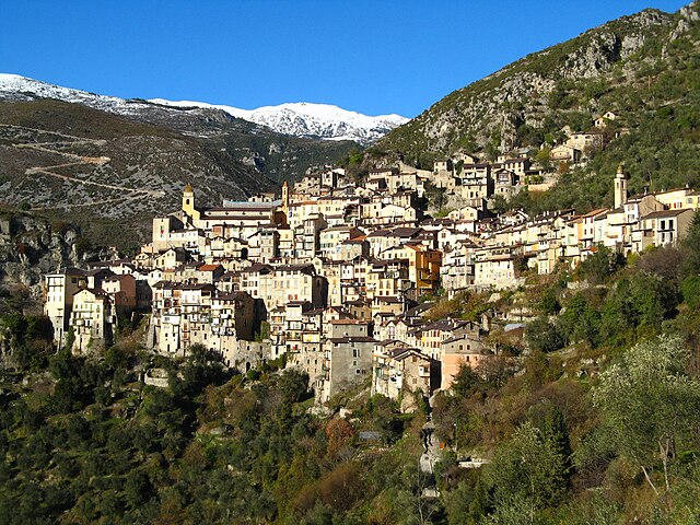

Саорж
- коммуна в департаменте Приморские Альпы, регион Прованс — Альпы — Лазурный Берег, Франция
Hiking in Саорж
Saorge is a picturesque village located in the Alpes-Maritimes region of France, not far from the Italian border. The area is known for its stunning landscapes, charming architecture, and an array of hiking opportunities that cater to different skill levels. Here are some highlights and trails to consider when hiking in and around Saorge:...
- Страна:
- Почтовый код: 06540
- Координаты: 43° 59' 14" N, 7° 33' 9" E
- GPS треки (wikiloc): [Ссылка]
- Высота над уровнем моря: 513 м m
- Площадь: 86.78 кв.км
- Население: 455
- Веб сайт: [Ссылка]