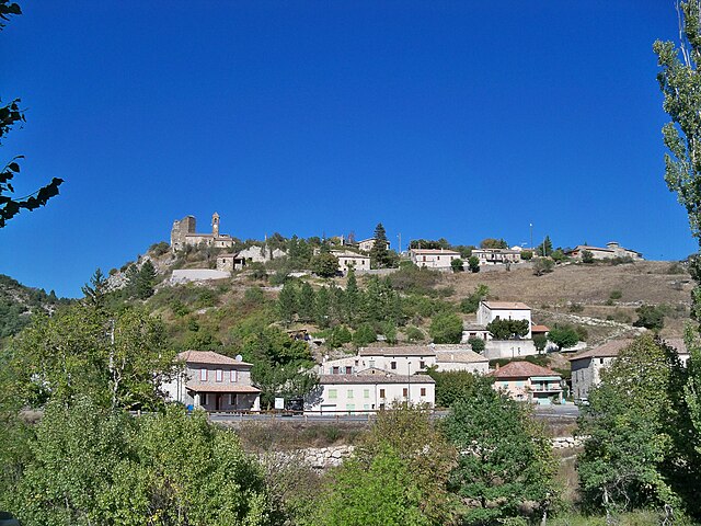
Розан (Rosans, Rosans)
- коммуна во Франции
 Hiking in Розан
Rosans is a charming village located in the Hautes-Alpes region of southeastern France, known for its picturesque landscapes, diverse flora, and a range of hiking opportunities. Here are some key points about hiking in and around Rosans:
-
Scenic Trails: The area offers various trails that cater to different skill levels, from easy strolls suitable for families to more challenging hikes for experienced trekkers. The routes often feature stunning views of the surrounding mountains, valleys, and the delightfully preserved architecture of the village.
-
Natural Parks: Rosans is close to several natural parks, including the Parc Naturel Régional des Baronnies Provençales. This park is known for its biodiversity, with many hiking routes allowing visitors to explore the unique ecosystems, from lavender fields to rocky outcrops.
-
Cultural Heritage: Some trails incorporate historical and cultural landmarks, allowing hikers to soak up the local culture along the way. You may find ruins of old castles, heritage sites, and traditional farms that highlight the region's history.
-
Wildlife Viewing: The area is home to a variety of wildlife, making it an excellent spot for nature enthusiasts. Birdwatchers, in particular, can enjoy spotting various species, especially in the spring and early summer months.
-
Seasonal Considerations: Hiking in Rosans can generally be enjoyed year-round, but conditions vary with the seasons. Spring and autumn are particularly pleasant, with mild weather and vibrant landscapes. However, winter hikes may require specific gear due to snow and ice.
-
Local Guides and Resources: For those unfamiliar with the area or looking for a more informative experience, hiring a local guide can enhance your hike. They can offer insights into the ecology and history of the region.
-
Safety: As with any hiking activity, it’s critical to prepare adequately. Carry plenty of water, snacks, a detailed map or GPS, and appropriate clothing for changing weather conditions.
Overall, hiking in Rosans offers a wonderful combination of nature, adventure, and cultural experiences, making it an excellent destination for outdoor enthusiasts. Before you go, be sure to check local maps and resources for the latest trail conditions and recommendations. Happy hiking!
- Страна:

- Почтовый код: 05150
- Координаты: 44° 23' 30" N, 5° 28' 12" E


- GPS треки (wikiloc): [Ссылка]
- Площадь: 30.39 кв.км
- Население: 492
- Веб сайт: http://www.rosans.fr
- Википедия русская: wiki(ru)
- Википедия английская: wiki(en)
- Википедия национальная: wiki(fr)
- Хранилище Wikidata: Wikidata: Q1020764
- Катеория в википедии: [Ссылка]
- код Freebase: [/m/03mfpcl]
- код Freebase: [/m/03mfpcl]
- код GeoNames: Альт: [6453561]
- код GeoNames: Альт: [6453561]
- номер SIREN: [210501268]
- номер SIREN: [210501268]
- код VIAF: Альт: [311197682]
- код VIAF: Альт: [311197682]
- код муниципалитета INSEE: 05126
- код муниципалитета INSEE: 05126
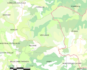
Граничит с регионами:

Сент-Андре-де-Розан
- коммуна во Франции
Hiking in Сент-Андре-де-Розан
Saint-André-de-Rosans is a charming village located in the Hautes-Alpes region of southeastern France. It's a fantastic area for hikers, offering a variety of trails that cater to different skill levels and preferences. Here are some highlights about hiking in this picturesque location:...
- Страна:
- Почтовый код: 05150
- Координаты: 44° 22' 38" N, 5° 30' 52" E
- GPS треки (wikiloc): [Ссылка]
- Площадь: 36.61 кв.км
- Население: 145

Муадан
- коммуна во Франции
Hiking in Муадан
Moydans is not a widely recognized hiking destination, and it seems there might be a spelling error or it might refer to a specific, lesser-known location or a local site unfamiliar to broader audiences. If you meant a different location or if it's a local spot, let me know!...
- Страна:
- Почтовый код: 05150
- Координаты: 44° 23' 59" N, 5° 30' 13" E
- GPS треки (wikiloc): [Ссылка]
- Высота над уровнем моря: 633 м m
- Площадь: 10.51 кв.км
- Население: 47
Verclause
- коммуна во Франции
Hiking in Verclause
Verclause, while not a widely known hiking destination, offers beautiful natural scenery and outdoor activities for hiking enthusiasts. It is likely part of a region that features picturesque landscapes, including perhaps rolling hills, forests, and potentially even rivers or lakes, depending on its geography....
- Страна:
- Почтовый код: 26510
- Координаты: 44° 22' 50" N, 5° 25' 40" E
- GPS треки (wikiloc): [Ссылка]
- Площадь: 26.14 кв.км
- Население: 62


Montferrand-la-Fare
- коммуна во Франции
Hiking in Montferrand-la-Fare
Montferrand-la-Fare is a charming commune located in the Provence-Alpes-Côte d'Azur region of southeastern France, particularly known for its picturesque landscapes and natural beauty. Hiking in this area can provide you with a wonderful experience, as it combines scenic views with the tranquility of rural France....
- Страна:
- Почтовый код: 26510
- Координаты: 44° 21' 36" N, 5° 26' 59" E
- GPS треки (wikiloc): [Ссылка]
- Высота над уровнем моря: 670 м m
- Площадь: 11.24 кв.км
- Население: 31


Lemps
- коммуна во Франции
Hiking in Lemps
Lemps, located in the Drôme department of France, offers a charming setting for hiking enthusiasts with its picturesque landscapes and varied terrain. The region is characterized by rolling hills, vineyards, and small villages, providing a peaceful backdrop for outdoor adventures....
- Страна:
- Почтовый код: 26510
- Координаты: 44° 21' 4" N, 5° 25' 8" E
- GPS треки (wikiloc): [Ссылка]
- Высота над уровнем моря: 774 м m
- Площадь: 16.04 кв.км
- Население: 47


Pommerol
- коммуна во Франции
Hiking in Pommerol
Pommerol, located in the heart of the French Alps, is a charming destination for hiking enthusiasts. The region is known for its stunning landscapes, diverse terrains, and picturesque villages. Here are some highlights and tips for hiking in Pommerol:...
- Страна:
- Почтовый код: 26470
- Координаты: 44° 26' 46" N, 5° 27' 8" E
- GPS треки (wikiloc): [Ссылка]
- Высота над уровнем моря: 890 м m
- Площадь: 9.83 кв.км
- Население: 20


Cornillac
- коммуна во Франции
Hiking in Cornillac
Cornillac is a lesser-known gem located in the French Alps, making it an ideal destination for hiking enthusiasts seeking scenic views and challenging trails. While not as crowded as some more popular destinations, it offers a variety of hiking opportunities suitable for different skill levels....
- Страна:
- Почтовый код: 26510
- Координаты: 44° 26' 35" N, 5° 23' 11" E
- GPS треки (wikiloc): [Ссылка]
- Площадь: 19.44 кв.км
- Население: 81