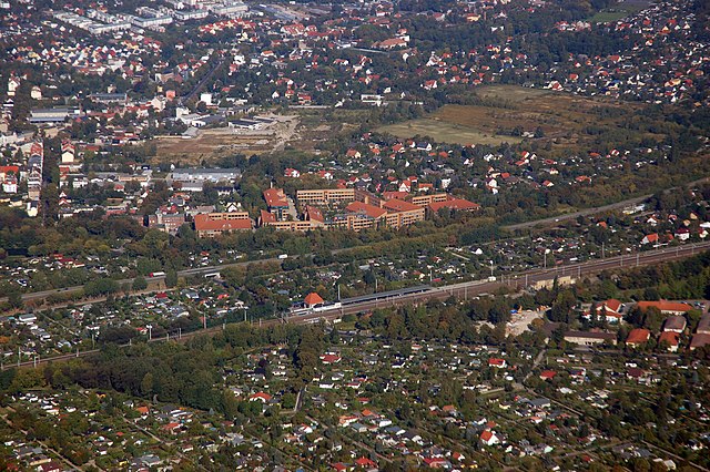
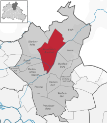
Розенталь (Rosenthal, Rosenthal)

- район Берлина
 Hiking in Розенталь
Rosenthal is a district in the northeastern part of Berlin, known for its natural beauty and green spaces, making it a lovely destination for hiking and outdoor activities. Though it's not a vast or well-known hiking hub compared to some larger parks or forests, it still offers some nice opportunities for nature walks and hikes.
Hiking Trails and Areas
-
Waldsiedlung Rosenthal: This area features picturesque trails that wind through forests and meadows. It’s a peaceful environment away from the city's hustle and bustle.
-
Tegeler Forst: Just nearby, this larger forest offers more extensive hiking opportunities. You can follow various marked trails that lead you through dense woods and around beautiful lakes.
-
Grunewald: Slightly further away, but accessible, Grunewald has a network of hiking trails, including routes around the famous Wannsee and the Teufelsberg hill, which provides stunning views of the surrounding area.
Tips for Hiking in Rosenthal
-
Maps and Routes: While the trails aren't as well-marked as in some national parks, you can find maps online or through local hiking organizations. It's a good idea to download routes or print maps beforehand if you're going off the beaten path.
-
Seasonal Hiking: Each season offers a different experience. Spring brings blooming flowers, summer is lush and green, autumn boasts beautiful foliage, and winter can offer peaceful, snowy landscapes.
-
Wildlife and Flora: Keep an eye out for local wildlife, such as deer and various bird species. The area has diverse flora as well, with rich deciduous forests.
-
Safety: Always inform someone of your hiking plans, especially if you plan to hike alone. Bring enough water, snacks, and dress according to the weather.
-
Local Amenities: Check for nearby cafes or restaurants in the district if you plan to pause for a break, and enjoy local cheeses and bread!
While Rosenthal may not be a premier hiking destination, it provides a serene backdrop for nature lovers and those looking to escape the busy city life, making it a charming option for a day of hiking or outdoor enjoyment in Berlin.
- Страна:

- Координаты: 52° 35' 57" N, 13° 22' 38" E


- GPS треки (wikiloc): [Ссылка]
- Высота над уровнем моря: 47 м m
- Площадь: 4.9 кв.км
- Википедия русская: wiki(ru)
- Википедия английская: wiki(en)
- Википедия национальная: wiki(de)
- Хранилище Wikidata: Wikidata: Q693521
- Галерея изображений в википедии: [Ссылка]
- Катеория в википедии: [Ссылка]
- Карты в википедии: [Ссылка]
- код Freebase: [/m/026vknj]
- код GeoNames: Альт: [2844910]
- код VIAF: Альт: [243901333]
- ID отношения в OpenStreetMap: [407651]
- код GND: Альт: [7600893-9]
- идентификатор местоположения ArchINFORM: [43341]
Граничит с регионами:


Нидершёнхаузен
- район в Берлине
Hiking in Нидершёнхаузен
Niederschönhausen is a district located in the Pankow borough of Berlin, Germany. While it may not be as widely known for hiking as some of the more rural areas surrounding Berlin, there are still opportunities for walks and nature exploration in and around the area....
- Страна:
- Координаты: 52° 35' 0" N, 13° 24' 0" E
- GPS треки (wikiloc): [Ссылка]
- Высота над уровнем моря: 48 м m
- Площадь: 6.49 кв.км
- Население: 28313


Вильгельмсру
- район в Берлине
Hiking in Вильгельмсру
Wilhelmsruh is a charming area located in Berlin, Germany, known for its natural beauty and peaceful surroundings. Though it may not be as prominent as some of the larger hiking destinations, it offers a unique blend of urban and natural landscapes, making it a fantastic spot for walking and light hiking....
- Страна:
- Координаты: 52° 35' 14" N, 13° 22' 5" E
- GPS треки (wikiloc): [Ссылка]
- Высота над уровнем моря: 44 м m
- Площадь: 1.37 кв.км
Францёзиш-Буххольц
- район в Берлине
Hiking in Францёзиш-Буххольц
Französisch Buchholz is a charming district located in the northern part of Berlin, Germany. While it may not be a traditional hiking destination like some of Germany's national parks, there are still several beautiful spots and trails in and around this area that offer pleasant walking and hiking experiences....
- Страна:
- Координаты: 52° 36' 0" N, 13° 26' 0" E
- GPS треки (wikiloc): [Ссылка]
- Высота над уровнем моря: 46 м m
- Площадь: 12 кв.км
Бланкенфельде
- район в Берлине
Hiking in Бланкенфельде
Blankenfelde, located in the state of Brandenburg, Germany, offers a variety of hiking opportunities amidst its picturesque landscapes, including forests, fields, and small lakes. Here are some highlights of hiking in the area:...
- Страна:
- Координаты: 52° 37' 7" N, 13° 23' 26" E
- GPS треки (wikiloc): [Ссылка]
- Высота над уровнем моря: 53 м m
- Площадь: 13.4 кв.км