Заксенхайм (Sachsenheim, Sachsenheim)

 Hiking in Заксенхайм
Sachsenheim, located in the state of Baden-Württemberg, Germany, offers some excellent opportunities for hiking enthusiasts. The region is characterized by picturesque landscapes, rolling hills, forests, and vineyards, making it a scenic destination for both casual walkers and serious hikers.
Hiking Trails:
-
Local Trails: Sachsenheim is connected to various local hiking routes. You can find well-marked trails ranging from easy to moderate difficulty, often leading through beautiful natural surroundings and offering views of vineyards and nearby hills.
-
Enz Valley Trail: Just a short distance from Sachsenheim, the Enz Valley offers trails that follow the Enz River, providing a mix of waterside walks and forest paths. This area is great for those who enjoy a more picturesque and tranquil setting.
-
Romantic Road: Part of the broader Romantic Road hiking route runs near Sachsenheim, featuring charming villages, historical sites, and beautiful landscapes.
Key Features:
-
Nature and Wildlife: The area surrounding Sachsenheim is rich in flora and fauna. Keep an eye out for wildlife, particularly in the forested areas.
-
Cultural Sites: While hiking, you might also come across historical landmarks, such as old mills, churches, and castles, which can add a cultural dimension to your hikes.
Preparation and Tips:
-
Suitable Gear: Wear sturdy hiking boots and appropriate clothing based on the weather. The terrain can vary from paved paths to more rugged trails.
-
Trail Maps: It’s a good idea to have a local hiking map or use a hiking app to ensure you stay on track and explore various routes.
-
Hydration and Snacks: Bring water and snacks, especially if you’re planning a longer hike. There are often spots to take a rest and enjoy your surroundings.
-
Respect Nature: Follow the Leave No Trace principles to minimize your impact on the environment and preserve the beautiful landscapes for future visitors.
Hiking in Sachsenheim can be a rewarding experience whether you're enjoying a peaceful day on the trails alone or sharing the adventure with friends or family. Always keep an eye on local resources for updated trail information and safety tips before you embark on your hike.
- Страна:

- Почтовый код: 74343
- Телефонный код: 07147; 07046
- Код автомобильного номера: LB
- Координаты: 48° 57' 36" N, 9° 3' 53" E


- GPS треки (wikiloc): [Ссылка]
- Высота над уровнем моря: 246 м m
- Площадь: 57.92 кв.км
- Население: 17861
- Веб сайт: https://www.sachsenheim.de/
- Википедия русская: wiki(ru)
- Википедия английская: wiki(en)
- Википедия национальная: wiki(de)
- Хранилище Wikidata: Wikidata: Q61920
- Катеория в википедии: [Ссылка]
- код Freebase: [/m/0dn5jj]
- код GeoNames: Альт: [2842513]
- код VIAF: Альт: [141960050]
- ID отношения в OpenStreetMap: [405823]
- код GND: Альт: [4383049-3]
- идентификатор местоположения ArchINFORM: [15537]
- код LCNAF: Альт: [n85149049]
- код TGN: [7173175]
- идентификатор муниципалитетов в Германии: 08118076
Граничит с регионами:

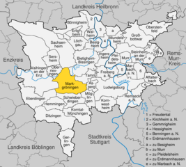
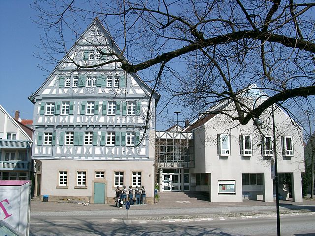
Маркгрёнинген
Hiking in Маркгрёнинген
Markgröningen is a charming town in the state of Baden-Württemberg, Germany, located near Stuttgart. While it may not be as widely recognized for hiking as some of the larger natural parks in the region, it provides access to scenic trails and the beautiful Swabian countryside....
- Страна:
- Почтовый код: 71706
- Телефонный код: 07147; 07145
- Код автомобильного номера: LB
- Координаты: 48° 54' 17" N, 9° 4' 51" E
- GPS треки (wikiloc): [Ссылка]
- Высота над уровнем моря: 281 м m
- Площадь: 28.16 кв.км
- Население: 14555
- Веб сайт: [Ссылка]


Пфаффенхофен
Hiking in Пфаффенхофен
Pfaffenhofen is a charming municipality in Baden-Württemberg, Germany, located in the picturesque Rems-Murr District. While it may not be as widely known as some larger hiking destinations, the region around Pfaffenhofen offers a variety of hiking opportunities that showcase the natural beauty and serene landscapes of southwest Germany....
- Страна:
- Почтовый код: 74397
- Телефонный код: 07046
- Код автомобильного номера: HN
- Координаты: 49° 3' 52" N, 8° 58' 35" E
- GPS треки (wikiloc): [Ссылка]
- Высота над уровнем моря: 207 м m
- Площадь: 12.04 кв.км
- Население: 2401
- Веб сайт: [Ссылка]

Гюглинген
- город в Германии
Hiking in Гюглинген
Güglingen, located in the state of Baden-Württemberg, Germany, offers a delightful blend of scenic beauty, charming landscapes, and historical sites for hikers and nature enthusiasts. Here are some key points about hiking in the region:...
- Страна:
- Почтовый код: 74363
- Телефонный код: 07135
- Код автомобильного номера: HN
- Координаты: 49° 4' 0" N, 9° 0' 0" E
- GPS треки (wikiloc): [Ссылка]
- Высота над уровнем моря: 206 м m
- Площадь: 16.27 кв.км
- Население: 6089
- Веб сайт: [Ссылка]


Цаберфельд
- коммуна в Германии
Hiking in Цаберфельд
Zaberfeld is a charming village in the Baden-Württemberg region of Germany, situated in the beautiful landscape of the Swabian Jura. It's an excellent starting point for hiking enthusiasts looking to explore both natural beauty and cultural sites....
- Страна:
- Почтовый код: 74374
- Телефонный код: 07046
- Код автомобильного номера: HN
- Координаты: 49° 3' 0" N, 8° 56' 0" E
- GPS треки (wikiloc): [Ссылка]
- Высота над уровнем моря: 228 м m
- Площадь: 22.18 кв.км
- Население: 3903
- Веб сайт: [Ссылка]


Клеброн
Hiking in Клеброн
Cleebronn is a charming town located in the Baden-Württemberg region of Germany, surrounded by beautiful natural landscapes that are perfect for hiking enthusiasts. The area is known for its scenic trails, vineyards, and the picturesque backdrop of the Swabian Jura....
- Страна:
- Почтовый код: 74389
- Телефонный код: 07135
- Код автомобильного номера: HN
- Координаты: 49° 3' 0" N, 9° 2' 0" E
- GPS треки (wikiloc): [Ссылка]
- Высота над уровнем моря: 236 м m
- Площадь: 2858 кв.км
- Население: 2858
- Веб сайт: [Ссылка]


Фройденталь
Hiking in Фройденталь
Freudental is a small village in the Baden-Württemberg region of Germany, nestled within the scenic landscape of the Stromberg region and close to the Enz Valley. While it may not be as widely recognized as some of Germany's larger hiking destinations, it serves as a lovely base for exploring the surrounding countryside....
- Страна:
- Почтовый код: 74392
- Телефонный код: 07143
- Код автомобильного номера: LB
- Координаты: 49° 0' 35" N, 9° 3' 33" E
- GPS треки (wikiloc): [Ссылка]
- Высота над уровнем моря: 293 м m
- Площадь: 3.07 кв.км
- Население: 2453
- Веб сайт: [Ссылка]


Оберриксинген
Hiking in Оберриксинген
Oberriexingen, a small town in the state of Baden-Württemberg in Germany, offers a variety of hiking opportunities that cater to different skill levels and preferences. Nestled near the scenic landscapes of the Swabian Jura and surrounded by vineyards, forests, and charming countryside, it serves as a great starting point for hikers looking to explore the region....
- Страна:
- Почтовый код: 71739
- Телефонный код: 07042
- Код автомобильного номера: LB
- Координаты: 48° 55' 32" N, 9° 1' 41" E
- GPS треки (wikiloc): [Ссылка]
- Высота над уровнем моря: 203 м m
- Площадь: 8.16 кв.км
- Население: 3251
- Веб сайт: [Ссылка]

Зерсхайм
Hiking in Зерсхайм
Sersheim is a small town located in the Baden-Württemberg region of Germany, known for its picturesque landscapes and scenic surroundings. While it may not be a widely known hiking destination, there are several opportunities for hiking nearby that showcase the natural beauty of the area....
- Страна:
- Почтовый код: 74372
- Телефонный код: 07042
- Код автомобильного номера: LB
- Координаты: 48° 58' 0" N, 9° 1' 0" E
- GPS треки (wikiloc): [Ссылка]
- Высота над уровнем моря: 217 м m
- Площадь: 11.48 кв.км
- Население: 5607
- Веб сайт: [Ссылка]


Бённигхайм
Hiking in Бённигхайм
Bönnigheim is a charming town located in Baden-Württemberg, Germany, surrounded by picturesque landscapes that make it a wonderful destination for hiking enthusiasts. Here are some key aspects you might find interesting about hiking in Bönnigheim:...
- Страна:
- Почтовый код: 74357
- Телефонный код: 07143
- Код автомобильного номера: LB
- Координаты: 49° 2' 27" N, 9° 5' 42" E
- GPS треки (wikiloc): [Ссылка]
- Высота над уровнем моря: 221 м m
- Площадь: 20.14 кв.км
- Население: 7593
- Веб сайт: [Ссылка]


Файхинген-на-Энце
Hiking in Файхинген-на-Энце
Vaihingen an der Enz, located in the state of Baden-Württemberg, Germany, offers a charming blend of scenic hikes and historical sites. The landscape is characterized by rolling hills, vineyards, and beautiful forests, making it a delightful spot for hiking enthusiasts of all skill levels....
- Страна:
- Почтовый код: 71665
- Телефонный код: 07042
- Координаты: 48° 55' 58" N, 8° 57' 23" E
- GPS треки (wikiloc): [Ссылка]
- Высота над уровнем моря: 217 м m
- Площадь: 73.41 кв.км
- Население: 29308
- Веб сайт: [Ссылка]


Лёхгау
Hiking in Лёхгау
Löchgau is a picturesque village located in the Baden-Württemberg region of Germany, not far from the cities of Heilbronn and Ludwigsburg. While it may not be as well-known for hiking as some of its more mountainous counterparts, Löchgau and its surrounding areas offer some lovely trails and scenic routes for those looking to enjoy nature....
- Страна:
- Почтовый код: 74369
- Телефонный код: 07143
- Код автомобильного номера: LB
- Координаты: 49° 0' 13" N, 9° 6' 23" E
- GPS треки (wikiloc): [Ссылка]
- Высота над уровнем моря: 260 м m
- Площадь: 10.95 кв.км
- Население: 5520
- Веб сайт: [Ссылка]


Битигхайм-Биссинген
Hiking in Битигхайм-Биссинген
Bietigheim-Bissingen is a charming town located in Baden-Württemberg, Germany, offering a pleasant combination of natural beauty and historical significance. The area is surrounded by picturesque landscapes, including forests, vineyards, and rivers, making it a great destination for hiking enthusiasts....
- Страна:
- Почтовый код: 74321
- Телефонный код: 07147; 07142
- Код автомобильного номера: LB
- Координаты: 48° 58' 0" N, 9° 8' 0" E
- GPS треки (wikiloc): [Ссылка]
- Высота над уровнем моря: 246 м m
- Площадь: 31.29 кв.км
- Население: 42968
- Веб сайт: [Ссылка]


Штерненфельс
Hiking in Штерненфельс
Sternenfels is a charming village located in the state of Baden-Württemberg, Germany, known for its beautiful landscapes and scenic hiking opportunities. Nestled in the northern part of the Swabian Jura, this area offers a variety of trails that cater to different skill levels, making it a great destination for both casual walkers and more experienced hikers....
- Страна:
- Почтовый код: 75447
- Телефонный код: 07045
- Код автомобильного номера: PF
- Координаты: 49° 3' 1" N, 8° 51' 2" E
- GPS треки (wikiloc): [Ссылка]
- Высота над уровнем моря: 397 м m
- Площадь: 17.31 кв.км
- Население: 2761
- Веб сайт: [Ссылка]