Сен-Клеман-сюр-Дюранс (Saint-Clément-sur-Durance, Saint-Clément-sur-Durance)
- коммуна во Франции
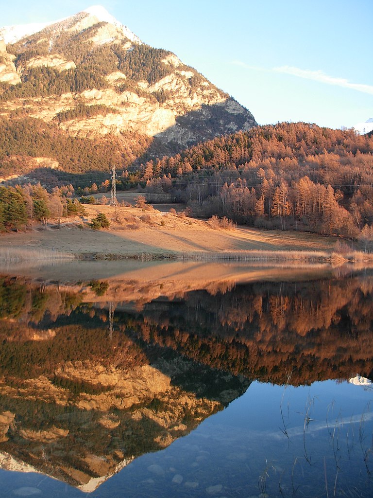
 Hiking in Сен-Клеман-сюр-Дюранс
Saint-Clément-sur-Durance, located in the Hautes-Alpes region of France, offers a variety of hiking opportunities amidst stunning natural scenery. The area is characterized by its picturesque landscapes, including mountains, rivers, and quaint villages. Here are some key points to consider for hiking in this area:
Hiking Trails
-
Varied Difficulty Levels: The hiking trails around Saint-Clément-sur-Durance cater to different levels of hikers, from beginners to experienced trekkers. You can find easy walks suitable for families as well as challenging routes for seasoned hikers.
-
Scenic Views: Many trails provide breathtaking views of the Durance Valley and the surrounding mountains. Be sure to take in the scenery and capture some photos along the way.
-
Wildlife Observation: The region is home to diverse flora and fauna. Keep an eye out for local wildlife, including various bird species and perhaps even some grazing animals like ibex.
Popular Hiking Areas
-
Les Écrins National Park: Just a bit further from Saint-Clément-sur-Durance, this national park features several well-marked hiking trails. Explore alpine meadows, glaciers, and dramatic mountain landscapes.
-
Le Parc Naturel Régional du Queyras: This nearby regional park offers extensive hiking paths and is known for its well-preserved landscapes, traditional villages, and cultural heritage.
Recommendations
-
Preparation: Always check the weather forecast before heading out and wear appropriate footwear. The terrain can vary significantly, so sturdy hiking boots are recommended.
-
Map and Navigation: Make sure to have a detailed map or a GPS device, as some trails may not be well-marked. Local tourist offices often provide maps and information about trail conditions.
-
Hydration and Snacks: Carry enough water and snacks, especially on longer hikes, as facilities may not always be available along the trail.
-
Respect Nature: Follow Leave No Trace principles to preserve the natural beauty of the area. Stay on marked trails, pack out what you pack in, and avoid disturbing wildlife.
Best Times to Go
The best time for hiking in and around Saint-Clément-sur-Durance is typically between late spring and early autumn (May to September). The weather is usually mild, but always check local conditions, as mountain weather can change rapidly.
Whether you're seeking a leisurely walk or a challenging trek, Saint-Clément-sur-Durance has something to offer every hiking enthusiast. Enjoy your adventure!
- Страна:

- Почтовый код: 05600
- Координаты: 44° 38' 56" N, 6° 34' 42" E


- GPS треки (wikiloc): [Ссылка]
- Высота над уровнем моря: 872 м m
- Площадь: 25.06 кв.км
- Население: 291
- Википедия русская: wiki(ru)
- Википедия английская: wiki(en)
- Википедия национальная: wiki(fr)
- Хранилище Wikidata: Wikidata: Q547288
- Катеория в википедии: [Ссылка]
- код Freebase: [/m/03mfp7g]
- код Freebase: [/m/03mfp7g]
- номер SIREN: [210501342]
- номер SIREN: [210501342]
- код муниципалитета INSEE: 05134
- код муниципалитета INSEE: 05134
Граничит с регионами:

Реотье
- коммуна во Франции
Hiking in Реотье
Réotier is a charming village located in the Hautes-Alpes region of France, near the border of Italy. It is nestled in the stunning natural landscape, characterized by mountains, rivers, and diverse flora and fauna, making it an excellent destination for hiking enthusiasts....
- Страна:
- Почтовый код: 05600
- Координаты: 44° 39' 50" N, 6° 35' 24" E
- GPS треки (wikiloc): [Ссылка]
- Площадь: 22.33 кв.км
- Население: 193
- Веб сайт: [Ссылка]
Сент-Андре-д’Эмбрён
- коммуна во Франции
Hiking in Сент-Андре-д’Эмбрён
Saint-André-d'Embrun is a charming village located in the southeastern part of France, nestled in the Hautes-Alpes region. It offers a variety of hiking opportunities that cater to different experience levels, making it a great destination for outdoor enthusiasts....
- Страна:
- Почтовый код: 05200
- Координаты: 44° 35' 10" N, 6° 32' 2" E
- GPS треки (wikiloc): [Ссылка]
- Площадь: 38.63 кв.км
- Население: 644

Гийестр
- коммуна во Франции
Hiking in Гийестр
Guillestre is a charming village located in the southern Alps of France, within the Hautes-Alpes department. It serves as an excellent base for various hiking adventures, offering a range of trails catering to different skill levels and providing stunning alpine scenery....
- Страна:
- Почтовый код: 05600
- Координаты: 44° 39' 37" N, 6° 38' 57" E
- GPS треки (wikiloc): [Ссылка]
- Площадь: 51.29 кв.км
- Население: 2301
- Веб сайт: [Ссылка]

Шатору-лез-Альп
- коммуна во Франции
Hiking in Шатору-лез-Альп
Châteauroux-les-Alpes is a charming village located in the Hautes-Alpes department in southeastern France. It is surrounded by beautiful mountainous landscapes, making it a great base for hiking enthusiasts. Here are some highlights of hiking in and around Châteauroux-les-Alpes:...
- Страна:
- Почтовый код: 05380
- Координаты: 44° 36' 52" N, 6° 31' 19" E
- GPS треки (wikiloc): [Ссылка]
- Площадь: 92.84 кв.км
- Население: 1146

Ризуль
- коммуна во Франции
Hiking in Ризуль
Risoul is a charming alpine village located in the French Alps, known primarily for its ski resort, but it also offers fantastic hiking opportunities during the warmer months. Here are some key points to consider if you're looking to hike in Risoul:...
- Страна:
- Почтовый код: 05600
- Координаты: 44° 38' 55" N, 6° 38' 24" E
- GPS треки (wikiloc): [Ссылка]
- Площадь: 30.34 кв.км
- Население: 638