
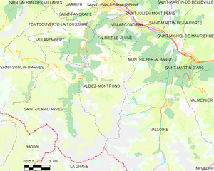
Saint-Jean-d'Arves (Saint-Jean-d'Arves)

- коммуна во Франции
 Hiking in Saint-Jean-d'Arves
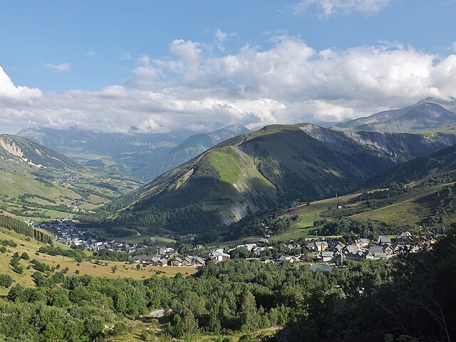
Saint-Jean-d'Arves is a picturesque village located in the French Alps, specifically in the Savoie region. This area is renowned for its stunning mountain landscapes, diverse wildlife, and a wide array of hiking opportunities. Here’s what you can expect when hiking in Saint-Jean-d'Arves:
Scenic Trails
- Various Difficulty Levels: The region offers a range of trails suitable for all skill levels, from easy walks for beginners to challenging routes for experienced hikers.
- Panoramic Views: Many trails provide breathtaking views of the surrounding mountains, including the famous Aiguilles d'Arves, a remarkable sight that dominates the landscape.
- Alpine Flora and Fauna: The area is rich in biodiversity, and you might encounter various species of plants and animals during your hikes.
Popular Hiking Trails
- Les Sentiers de Découverte: This is a network of discovery trails that cater to families and those looking for a leisurely experience. They often include informative signs about the local ecology.
- Lacs de la Tempête: A beautiful hike that leads to serene alpine lakes, perfect for a picnic or a peaceful break amidst nature.
- Col de la Croix de Fer: A more challenging hike that rewards you with stunning views and the chance to appreciate the high mountain environment.
Hiking Tips
- Season: Summer (June to September) is the best time for hiking in Saint-Jean-d'Arves, as trails are usually clear of snow and the weather is more stable.
- Gear: Proper hiking footwear is essential. Consider bringing trekking poles, a map, and enough water and snacks for your hike.
- Safety: Always check the weather forecast, inform someone of your plans, and start early to allow plenty of daylight for your hike.
Other Activities
In addition to hiking, Saint-Jean-d'Arves offers various outdoor activities such as mountain biking, paragliding, and in winter, skiing in the nearby resorts.
Whether you're looking for a leisurely stroll or a demanding hike, Saint-Jean-d'Arves provides a beautiful backdrop for an unforgettable outdoor experience. Be sure to appreciate the local culture and the warm hospitality of the region as you enjoy your adventure!
- Страна:

- Почтовый код: 73530
- Координаты: 45° 12' 26" N, 6° 16' 23" E


- GPS треки (wikiloc): [Ссылка]
- Площадь: 75.6 кв.км
- Население: 265
- Веб сайт: https://www.saintjeandarves.fr/
- Википедия английская: wiki(en)
- Википедия национальная: wiki(fr)
- Хранилище Wikidata: Wikidata: Q1158010
- Катеория в википедии: [Ссылка]
- код Freebase: [/m/058lr0]
- номер SIREN: [217302421]
- код BNF: [152741733]
- код муниципалитета INSEE: 73242
Граничит с регионами:


Бесс
- коммуна во Франции
Hiking in Бесс
Besse, located in the Isère department of the Auvergne-Rhône-Alpes region in southeastern France, is a fantastic destination for hiking enthusiasts. Nestled in the spectacular landscapes of the French Alps, Besse offers a range of hiking trails that cater to various levels of experience, from beginner to expert....
- Страна:
- Почтовый код: 38142
- Координаты: 45° 4' 18" N, 6° 10' 12" E
- GPS треки (wikiloc): [Ссылка]
- Площадь: 25.46 кв.км
- Население: 133
- Веб сайт: [Ссылка]

Альбье-Монрон
- коммуна во Франции
Hiking in Альбье-Монрон
Albiez-Montrond is a charming alpine village located in the Savoie region of the French Alps, known for its stunning mountain scenery and outdoor activities, including hiking. Here are some details about hiking in this beautiful area:...
- Страна:
- Почтовый код: 73300
- Координаты: 45° 13' 11" N, 6° 20' 27" E
- GPS треки (wikiloc): [Ссылка]
- Площадь: 48.58 кв.км
- Население: 382
- Веб сайт: [Ссылка]

Saint-Sorlin-d'Arves
- коммуна во Франции
Hiking in Saint-Sorlin-d'Arves
Saint-Sorlin-d'Arves is a beautiful alpine village located in the Savoie region of the French Alps. It is particularly known for its stunning landscapes, diverse wildlife, and a range of hiking trails that cater to various skill levels. Here’s a general overview of what you can expect when hiking in the area:...
- Страна:
- Почтовый код: 73530
- Координаты: 45° 13' 16" N, 6° 14' 5" E
- GPS треки (wikiloc): [Ссылка]
- Площадь: 39 кв.км
- Население: 339
- Веб сайт: [Ссылка]


Фонкуверт-ля-Туссюир
- коммуна во Франции
Hiking in Фонкуверт-ля-Туссюир
Fontcouverte-la-Toussuire is a picturesque village located in the Savoie region of the French Alps, offering a variety of hiking opportunities for outdoor enthusiasts. Whether you’re a beginner or an advanced hiker, the area provides trails that cater to different skill levels, along with stunning mountain scenery, alpine flora, and the chance to spot local wildlife....
- Страна:
- Почтовый код: 73300
- Координаты: 45° 14' 47" N, 6° 18' 9" E
- GPS треки (wikiloc): [Ссылка]
- Площадь: 21.52 кв.км
- Население: 534
- Веб сайт: [Ссылка]

Ла-Грав
- коммуна во Франции
Hiking in Ла-Грав
La Grave is a stunning area located in the French Alps, known for its breathtaking mountain scenery and varied hiking opportunities. Here are some key points to consider if you're planning a hiking trip in La Grave:...
- Страна:
- Почтовый код: 05320
- Координаты: 45° 2' 46" N, 6° 18' 21" E
- GPS треки (wikiloc): [Ссылка]
- Площадь: 126.91 кв.км
- Население: 487
- Веб сайт: [Ссылка]


Villarembert
- коммуна во Франции
Hiking in Villarembert
Villarembert is a charming village located in the Savoie region of the French Alps, known for its beautiful landscapes and access to numerous hiking trails. It's particularly popular among outdoor enthusiasts due to its proximity to the Maurienne Valley and the Trois Vallées ski area, which transforms into a hiker's paradise in the summer months....
- Страна:
- Почтовый код: 73300
- Координаты: 45° 14' 45" N, 6° 16' 46" E
- GPS треки (wikiloc): [Ссылка]
- Площадь: 9.58 кв.км
- Население: 249
- Веб сайт: [Ссылка]


Valloire
- коммуна во Франции
Hiking in Valloire
Valloire is a charming mountain village located in the Savoie region of the French Alps. It's known for its stunning landscapes, rich heritage, and excellent opportunities for hiking and outdoor activities. Here are some highlights of hiking in Valloire:...
- Страна:
- Почтовый код: 73450
- Координаты: 45° 9' 55" N, 6° 25' 42" E
- GPS треки (wikiloc): [Ссылка]
- Площадь: 137.48 кв.км
- Население: 1135
- Веб сайт: [Ссылка]