Saint-Lamain (Saint-Lamain)

- коммуна во Франции
 Hiking in Saint-Lamain
Saint-Lamain is a charming destination for hiking enthusiasts, offering picturesque landscapes and a variety of trails suitable for all levels of hikers. While it's not one of the most well-known hiking spots, it can be a hidden gem for those who seek tranquil nature experiences.
Trail Options
-
Beginner Trails: If you're new to hiking, look for shorter, well-marked paths that provide gentle elevation changes and stunning views of the surrounding nature. These are perfect for families or casual hikers.
-
Intermediate Trails: For those with some experience, trails that feature moderate challenges, such as steeper inclines or varying terrain, can offer a great workout while still being manageable.
-
Advanced Trails: Experienced hikers can explore more challenging routes that may include rugged terrain, higher altitudes, or longer distances.
Scenic Highlights
- Natural Beauty: The region is known for its enchanting scenery, including forests, rivers, and perhaps even viewpoints that offer breathtaking panoramic vistas.
- Wildlife: Look out for local wildlife, as the area is often home to various birds and small mammals.
Best Time to Hike
- The ideal seasons for hiking would generally be spring and fall, where the weather is mild, and the flora displays vibrant colors.
- Summer can also be nice, but be prepared for warmer temperatures, and remember to hydrate.
Preparation Tips
- Gear: Wear sturdy hiking boots, and carry a map or a GPS device. A hydration pack or water bottle is essential, along with snacks for energy.
- Safety: Always inform someone about your hiking plans, especially if you’re venturing into less-traveled areas.
- Leave No Trace: Be sure to follow the principles of Leave No Trace to protect the environment.
Additional Considerations
- Local regulations regarding trail access and any entrance fees should be checked ahead of time.
- It may be worth connecting with local hiking groups or clubs for guided experiences and to meet fellow outdoor enthusiasts.
Make sure to check current trail conditions before you go, as weather and maintenance can affect accessibility. Happy hiking!
- Страна:

- Почтовый код: 39230
- Координаты: 46° 47' 44" N, 5° 36' 9" E


- GPS треки (wikiloc): [Ссылка]
- Площадь: 4.16 кв.км
- Население: 117
- Википедия английская: wiki(en)
- Википедия национальная: wiki(fr)
- Хранилище Wikidata: Wikidata: Q614598
- Катеория в википедии: [Ссылка]
- код Freebase: [/m/03nvv0s]
- код Freebase: [/m/03nvv0s]
- код GeoNames: Альт: [6433742]
- код GeoNames: Альт: [6433742]
- номер SIREN: [213904865]
- номер SIREN: [213904865]
- код BNF: [15258848c]
- код BNF: [15258848c]
- код муниципалитета INSEE: 39486
- код муниципалитета INSEE: 39486
Граничит с регионами:


Saint-Lothain
- коммуна во Франции
Hiking in Saint-Lothain
Saint-Lothain is a small commune located in the Jura department of France, known for its beautiful landscapes, picturesque vineyards, and proximity to the Jura Mountains. It offers a range of outdoor activities, including hiking, that will appeal to nature enthusiasts and those looking to explore the local environment....
- Страна:
- Почтовый код: 39230
- Координаты: 46° 49' 32" N, 5° 38' 40" E
- GPS треки (wikiloc): [Ссылка]
- Площадь: 12.33 кв.км
- Население: 473

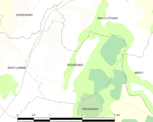
Passenans
- коммуна во Франции
Hiking in Passenans
Passenans is a charming village located in the Jura region of France, known for its beautiful landscapes and outdoor activities, including hiking. The area is surrounded by lush forests, rolling hills, and serene lakes, making it an excellent destination for nature lovers and hikers of all skill levels....
- Страна:
- Почтовый код: 39230
- Координаты: 46° 47' 53" N, 5° 37' 8" E
- GPS треки (wikiloc): [Ссылка]
- Площадь: 4.94 кв.км
- Население: 352


Toulouse-le-Château
- коммуна во Франции
Hiking in Toulouse-le-Château
Toulouse-le-Château is a charming small commune located in the Bourgogne-Franche-Comté region of eastern France. While it may not be as widely known for hiking as some larger areas, it still offers opportunities for outdoor enthusiasts looking to explore the beautiful countryside and picturesque landscapes....
- Страна:
- Почтовый код: 39230
- Координаты: 46° 49' 23" N, 5° 35' 13" E
- GPS треки (wikiloc): [Ссылка]
- Площадь: 4.16 кв.км
- Население: 217


Darbonnay
- коммуна во Франции
Hiking in Darbonnay
Darbonnay is a picturesque area located in the Jura Mountains of France, known for its stunning natural landscapes and diverse hiking opportunities. While it may not be as widely recognized as other hiking destinations, it offers a unique experience for outdoor enthusiasts....
- Страна:
- Почтовый код: 39230
- Координаты: 46° 48' 58" N, 5° 36' 15" E
- GPS треки (wikiloc): [Ссылка]
- Площадь: 4.39 кв.км
- Население: 94


Mantry
- коммуна во Франции
Hiking in Mantry
Hiking in Mantry can be a wonderful experience, as it offers a variety of trails and natural beauty. However, please note that "Mantry" may refer to different locations depending on the context. If you mean a specific region or trail system, it would be helpful to clarify that....
- Страна:
- Почтовый код: 39230
- Координаты: 46° 47' 47" N, 5° 33' 33" E
- GPS треки (wikiloc): [Ссылка]
- Площадь: 10.83 кв.км
- Население: 443

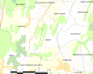
Bréry
- коммуна во Франции
Hiking in Bréry
Bréry is not a widely recognized hiking destination, so there might be some confusion regarding its specific location. However, if you're referring to a region or area with that name, it's best to consider general hiking tips and recommendations that apply to most hiking locations....
- Страна:
- Почтовый код: 39230
- Координаты: 46° 47' 2" N, 5° 34' 45" E
- GPS треки (wikiloc): [Ссылка]
- Площадь: 4.85 кв.км
- Население: 229


Фронтене
- коммуна во Франции
Hiking in Фронтене
Frontenay, located in France's Nouvelle-Aquitaine region, is not widely recognized for hiking specifically, but the surrounding areas and landscapes offer beautiful opportunities for outdoor activities, including hiking. Here are some insights on hiking in and around Frontenay:...
- Страна:
- Почтовый код: 39210
- Координаты: 46° 47' 8" N, 5° 36' 51" E
- GPS треки (wikiloc): [Ссылка]
- Площадь: 8.13 кв.км
- Население: 178