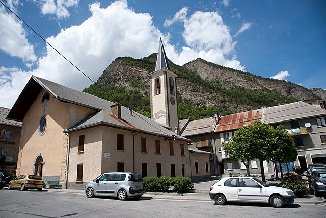
Сен-Пон (Saint-Pons, Saint-Pons)
 Hiking in Сен-Пон
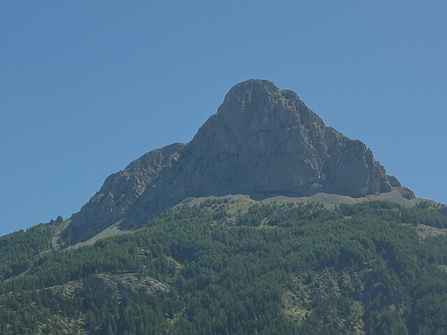
Saint-Pons, located in the Alpes-de-Haute-Provence region of France, is a fantastic destination for hiking enthusiasts. Known for its stunning natural scenery, diverse landscapes, and relatively mild climate, it offers a variety of trails suitable for different skill levels. Here are some key features and tips for hiking in this area:
Scenery
- Diverse Landscapes: The region boasts a mix of forested areas, mountainous terrain, lush valleys, and picturesque villages. The backdrop of the Southern Alps provides a dramatic setting for your hikes.
- Flora and Fauna: You’ll encounter varied vegetation, including pine forests, scrublands, and wildflower meadows. Wildlife enthusiasts may spot several species of birds and other animals native to the region.
Popular Hiking Trails
- Sentier des Rocs: This trail offers stunning views and is accessible for hikers of all skill levels. It’s a great way to experience the unique geology of the area.
- GR4 Trail: Part of the Grande Randonnée network, this long-distance trail crosses through the region, allowing hikers to experience the diverse landscapes and enjoy extended hikes.
- Local Loop Trails: There are various local trails, often marked with signage, leading to nearby villages such as Saint-Julien or Saint-Étienne-les-Orgues, ideal for shorter day hikes.
Practical Considerations
- Best Time to Hike: The best hiking season generally runs from spring (April - June) to early autumn (September - October), with mild weather and blooming landscapes. Summer can be hot, so taking precautions for heat is advisable.
- Trail Markings: Make sure to check the markings on the trails, as they can vary. Look for the red and white marks for GR routes and yellow for local paths.
- Safety: Always carry enough water, wear appropriate footwear, and be prepared for changing weather conditions. It’s advisable to inform someone about your hiking plans, especially for longer excursions.
Additional Activities
- Cultural Exploration: Take time to explore the charming village of Saint-Pons and its local culture, including historical architecture and traditional cuisine.
- Photography: The stunning landscapes and unique flora make it a great spot for photography, so don’t forget your camera.
In summary, Saint-Pons in the Alpes-de-Haute-Provence is an excellent hiking destination for all levels, offering breathtaking natural beauty and a variety of trails. Be sure to plan your hikes according to your fitness level and the weather conditions, and enjoy the adventure!
- Страна:

- Почтовый код: 04400
- Координаты: 44° 23' 32" N, 6° 37' 40" E


- GPS треки (wikiloc): [Ссылка]
- Площадь: 32.06 кв.км
- Население: 647
- Веб сайт: http://www.saintpons-ubaye.fr
- Википедия русская: wiki(ru)
- Википедия английская: wiki(en)
- Википедия национальная: wiki(fr)
- Хранилище Wikidata: Wikidata: Q1017891
- Катеория в википедии: [Ссылка]
- код Freebase: [/m/03m806w]
- код Freebase: [/m/03m806w]
- код GeoNames: Альт: [6615716]
- код GeoNames: Альт: [6615716]
- номер SIREN: [210401956]
- номер SIREN: [210401956]
- код VIAF: Альт: [237021367]
- код VIAF: Альт: [237021367]
- код муниципалитета INSEE: 04195
- код муниципалитета INSEE: 04195
Граничит с регионами:

Ле-Тюиль
- коммуна во Франции
Hiking in Ле-Тюиль
Les Thuiles is a picturesque village located in the French region of Provence-Alpes-Côte d'Azur, specifically in the Alpes-de-Haute-Provence department. Hiking in this area offers a wonderful experience, as it is surrounded by stunning natural landscapes, including mountains, valleys, and forests....
- Страна:
- Почтовый код: 04400
- Координаты: 44° 23' 35" N, 6° 34' 16" E
- GPS треки (wikiloc): [Ссылка]
- Площадь: 32.8 кв.км
- Население: 398
Юверне-Фур
- коммуна во Франции
Hiking in Юверне-Фур
Uvernet-Fours is a charming destination in the French Alpes-de-Haute-Provence region, known for its beautiful landscapes and outdoor recreational opportunities, including hiking. Here are some details to help you plan your hiking experience in this area:...
- Страна:
- Почтовый код: 04400
- Координаты: 44° 21' 40" N, 6° 37' 34" E
- GPS треки (wikiloc): [Ссылка]
- Площадь: 135.44 кв.км
- Население: 583

Лез-Ор
- коммуна во Франции
Hiking in Лез-Ор
Les Orres, located in the French Alps, is a fantastic destination for hiking enthusiasts. This charming mountain resort offers a variety of trails suitable for all levels, from beginners to experienced hikers. Here’s an overview to help you plan your hiking experience in Les Orres:...
- Страна:
- Почтовый код: 05200
- Координаты: 44° 30' 50" N, 6° 33' 3" E
- GPS треки (wikiloc): [Ссылка]
- Высота над уровнем моря: 1460 м m
- Площадь: 74.79 кв.км
- Население: 569
- Веб сайт: [Ссылка]

Фокон-де-Барселоннет
- коммуна во Франции
Hiking in Фокон-де-Барселоннет
Faucon-de-Barcelonnette is a charming village located in the Alpes-de-Haute-Provence region of France, surrounded by stunning landscapes that are perfect for hiking enthusiasts. The area features a variety of trails suitable for different skill levels, ranging from easy walks to more challenging treks, making it an excellent destination for hikers of all experiences....
- Страна:
- Почтовый код: 04400
- Координаты: 44° 23' 37" N, 6° 40' 42" E
- GPS треки (wikiloc): [Ссылка]
- Площадь: 17.42 кв.км
- Население: 303
- Веб сайт: [Ссылка]

Барселоннет
- коммуна во Франции
Hiking in Барселоннет
Barcelonnette, nestled in the Ubaye Valley in the French Alps, is known for its stunning landscapes, charming architecture, and vibrant outdoor activities, including hiking. Here’s a guide to hiking in this beautiful area:...
- Страна:
- Почтовый код: 04400
- Координаты: 44° 23' 9" N, 6° 39' 9" E
- GPS треки (wikiloc): [Ссылка]
- Площадь: 16.42 кв.км
- Население: 2622
- Веб сайт: [Ссылка]
Ла-Кондамин-Шатлар
- коммуна во Франции
Hiking in Ла-Кондамин-Шатлар
La Condamine-Châtelard is a picturesque village located in the Alpes-Maritimes region of France, near the Italian border. It's a part of the larger area of the French Alps, known for its stunning natural landscapes and outdoor recreational opportunities, including hiking....
- Страна:
- Почтовый код: 04530
- Координаты: 44° 27' 29" N, 6° 44' 45" E
- GPS треки (wikiloc): [Ссылка]
- Высота над уровнем моря: 1305 м m
- Площадь: 56.08 кв.км
- Население: 172