Сен-Совёр (Saint-Sauveur, Saint-Sauveur)
 Hiking in Сен-Совёр
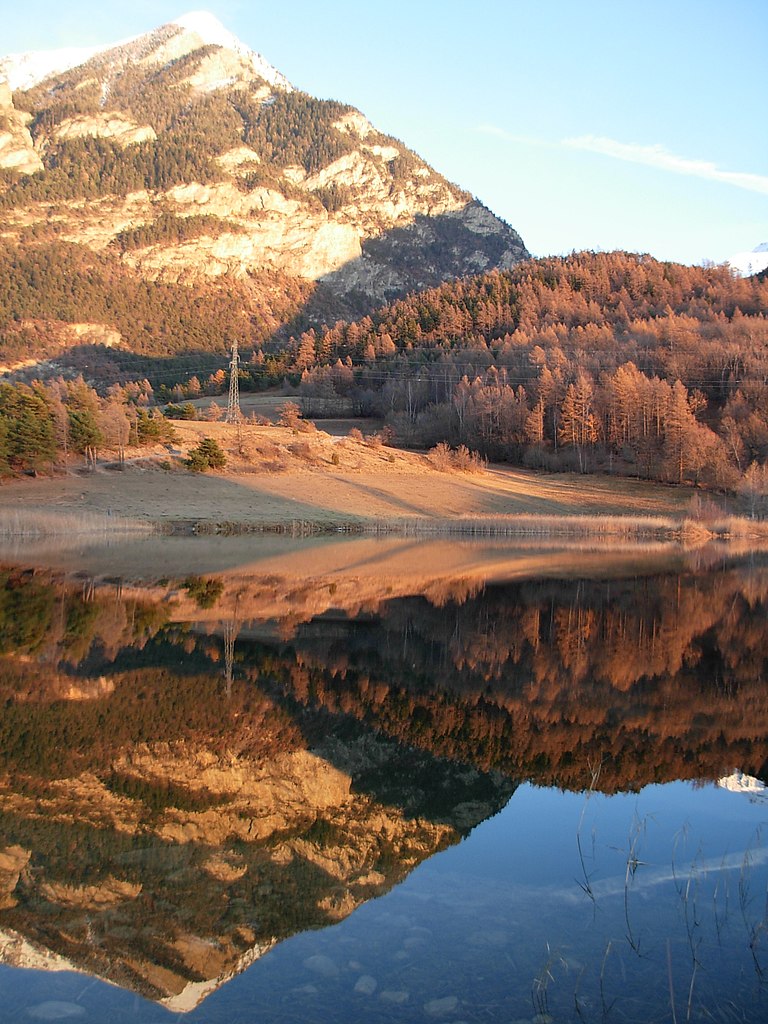
Saint-Sauveur in the Hautes-Alpes region of France is a beautiful destination for hiking enthusiasts. Nestled in the French Alps, it offers stunning landscapes, diverse terrain, and a variety of trails suitable for different skill levels. Here are some key points about hiking in this area:
Scenery and Landscape
- Mountain Views: The region is characterized by its impressive mountain ranges, including parts of the Écrins National Park. Hikers can enjoy breathtaking panoramas and dramatic alpine scenery.
- Flora and Fauna: The diverse ecosystems range from lush valleys to rocky mountainsides, giving hikers the opportunity to observe various plants and wildlife, including ibex, chamois, and many bird species.
Hiking Trails
- Trail Options: There are numerous well-marked trails around Saint-Sauveur, ranging from easy walks suitable for families to challenging routes for experienced hikers. The GR (Grande Randonnée) routes offer long-distance hiking experiences connecting various parts of the region.
- Accessibility: Many trails start from the village itself or can be reached by short drives into the surrounding areas, ensuring accessibility.
Recommended Hikes
- The Col de la Pra: This hike provides stunning views of the surrounding peaks and is a moderate trek that offers a good mix of challenge and beauty.
- Lake de l'Eychauda: A beautiful alpine lake that can be accessed via a moderate hike. The area around the lake is perfect for a picnic or a relaxing break.
- The Ecrins National Park: Explore some of the park's trails which provide panoramic views and a deeper dive into the natural beauty of the mountains.
Best Season to Hike
- Summer (June to September): This is the best time for hiking, with warm weather and accessible trails. However, it's important to check conditions as higher elevation trails may still have snow early in the season.
- Autumn (September to October): Offers beautiful fall colors and fewer crowds, making it a great time for hiking.
Tips for Hiking in Saint-Sauveur
- Preparation: Prior to hiking, it's advisable to check weather conditions and trail statuses, as mountain weather can change rapidly.
- Safety Gear: Always carry essential gear, including appropriate footwear, clothing, maps, water, and snacks.
- Respect Nature: Follow Leave No Trace principles to preserve the natural beauty of the area.
Whether you are looking for a peaceful day hike or a more adventurous experience, hiking in Saint-Sauveur and its surrounding areas offers something for everyone. Enjoy your hike!
- Страна:

- Почтовый код: 05200
- Координаты: 44° 32' 27" N, 6° 31' 13" E


- GPS треки (wikiloc): [Ссылка]
- Площадь: 24.18 кв.км
- Население: 454
- Википедия русская: wiki(ru)
- Википедия английская: wiki(en)
- Википедия национальная: wiki(fr)
- Хранилище Wikidata: Wikidata: Q1085603
- Катеория в википедии: [Ссылка]
- код Freebase: [/m/03m81_m]
- код Freebase: [/m/03m81_m]
- код GeoNames: Альт: [6453564]
- код GeoNames: Альт: [6453564]
- номер SIREN: [210501565]
- номер SIREN: [210501565]
- код муниципалитета INSEE: 05156
- код муниципалитета INSEE: 05156
Граничит с регионами:
Сент-Андре-д’Эмбрён
- коммуна во Франции
Hiking in Сент-Андре-д’Эмбрён
Saint-André-d'Embrun is a charming village located in the southeastern part of France, nestled in the Hautes-Alpes region. It offers a variety of hiking opportunities that cater to different experience levels, making it a great destination for outdoor enthusiasts....
- Страна:
- Почтовый код: 05200
- Координаты: 44° 35' 10" N, 6° 32' 2" E
- GPS треки (wikiloc): [Ссылка]
- Площадь: 38.63 кв.км
- Население: 644

Лез-Ор
- коммуна во Франции
Hiking in Лез-Ор
Les Orres, located in the French Alps, is a fantastic destination for hiking enthusiasts. This charming mountain resort offers a variety of trails suitable for all levels, from beginners to experienced hikers. Here’s an overview to help you plan your hiking experience in Les Orres:...
- Страна:
- Почтовый код: 05200
- Координаты: 44° 30' 50" N, 6° 33' 3" E
- GPS треки (wikiloc): [Ссылка]
- Высота над уровнем моря: 1460 м m
- Площадь: 74.79 кв.км
- Население: 569
- Веб сайт: [Ссылка]

Амбрён
- коммуна во Франции
Hiking in Амбрён
Embrun, located in the Hautes-Alpes region of France, is a fantastic destination for hiking enthusiasts. Nestled in the French Alps, the area boasts stunning landscapes, diverse flora and fauna, and a variety of trails suitable for all skill levels....
- Страна:
- Почтовый код: 05200
- Координаты: 44° 33' 54" N, 6° 29' 43" E
- GPS треки (wikiloc): [Ссылка]
- Высота над уровнем моря: 1789 м m
- Площадь: 36.39 кв.км
- Население: 6177
- Веб сайт: [Ссылка]

Баратье
- коммуна во Франции
Hiking in Баратье
Baratier, a small commune located in the French Alps near the Écrins National Park, offers stunning landscapes and a variety of hiking opportunities. Here are some key points to consider when exploring this beautiful area:...
- Страна:
- Почтовый код: 05200
- Координаты: 44° 32' 16" N, 6° 29' 43" E
- GPS треки (wikiloc): [Ссылка]
- Площадь: 15.99 кв.км
- Население: 559

Креву
- коммуна во Франции
Hiking in Креву
Crévoux is a picturesque village located in the French Alps, part of the Hautes-Alpes department, and is often celebrated for its stunning natural beauty and outdoor recreational opportunities, including fantastic hiking trails. Here are some highlights to help you prepare for a hiking adventure in Crévoux:...
- Страна:
- Почтовый код: 05200
- Координаты: 44° 32' 53" N, 6° 36' 26" E
- GPS треки (wikiloc): [Ссылка]
- Площадь: 56.26 кв.км
- Население: 140