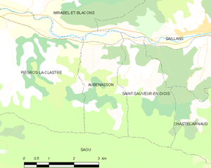
Saint-Sauveur-en-Diois (Saint-Sauveur-en-Diois)

- коммуна во Франции
 Hiking in Saint-Sauveur-en-Diois
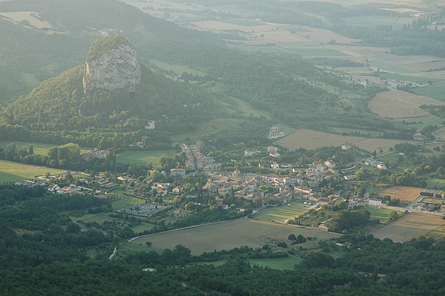
Saint-Sauveur-en-Diois is a charming village located in the Drôme department of the Auvergne-Rhône-Alpes region in southeastern France. The area is known for its stunning landscapes and diverse hiking opportunities, making it an ideal destination for outdoor enthusiasts.
Hiking Trails
-
Vercors Regional Natural Park: Just a short distance from Saint-Sauveur-en-Diois, this park offers numerous trails that range in difficulty from easy walks to challenging hikes. You can explore dramatic cliffs, deep gorges, and scenic vistas.
-
Local Circuits: The village and surrounding areas have well-marked trails. One popular route is the loop that takes hikers through picturesque countryside, past vineyards, and along the banks of the river Drôme.
-
Le Col de la Machine: This hiking route is a classic for those looking for panoramic views of the Vercors. It’s a moderate hike that rewards you with breathtaking scenery.
-
Montagnette Trail: This trail offers a decent climb and is suitable for those looking for a workout combined with some incredible viewpoints.
Flora and Fauna
Hiking in this area also offers the chance to witness a diverse range of flora and fauna. The region is rich in wildlife, including various bird species, deer, and endemic plants, making it a great spot for nature lovers and photographers.
Best Times to Hike
- Spring (April to June): The trails are often less crowded, and wildflowers are blooming, making for picturesque hikes.
- Summer (July to August): Great weather, but it can be quite busy with tourists. Make sure to start hikes early in the morning to avoid the heat.
- Autumn (September to October): This is a fantastic time to hike, as the fall foliage offers stunning colors, and the temperatures are usually mild.
- Winter: While some trails may be accessible for winter hikes, it is essential to check local conditions and prepare accordingly for colder temperatures.
Essential Tips
- Maps and Guides: It's advisable to carry a good map or guide of the hiking paths in the area. Local tourist offices often provide helpful resources.
- Weather Conditions: The weather can change quickly, especially in mountainous terrain, so dress in layers and prepare for all conditions.
- Stay Hydrated: Always carry enough water, as some trails don't have easy access to drinking water.
- Respect Nature: Follow Leave No Trace principles to help preserve the pristine environment.
Conclusion
Hiking in Saint-Sauveur-en-Diois is an enriching experience, combining scenic beauty, cultural heritage, and physical challenge. Whether you're looking for a leisurely stroll or a more demanding trek, this region offers something for everyone. Enjoy your adventure!
- Страна:

- Почтовый код: 26340
- Координаты: 44° 40' 50" N, 5° 9' 24" E


- GPS треки (wikiloc): [Ссылка]
- Площадь: 6.95 кв.км
- Население: 55
- Википедия английская: wiki(en)
- Википедия национальная: wiki(fr)
- Хранилище Wikidata: Wikidata: Q219313
- Катеория в википедии: [Ссылка]
- код Freebase: [/m/03mhl1s]
- код GeoNames: Альт: [6430236]
- номер SIREN: [212603286]
- код BNF: [15253188g]
- код муниципалитета INSEE: 26328
Граничит с регионами:

Saou
Hiking in Saou
Saou is a picturesque village located in the Drôme department of southeastern France, known for its stunning natural beauty, particularly its limestone cliffs and rolling hills. Hiking in Saou offers a mix of scenic views, diverse landscapes, and historical sites, making it a great destination for outdoor enthusiasts....
- Страна:
- Почтовый код: 26400
- Координаты: 44° 38' 45" N, 5° 3' 44" E
- GPS треки (wikiloc): [Ссылка]
- Площадь: 41.6 кв.км
- Население: 541


Saillans
- коммуна во Франции
Hiking in Saillans
Saillans, located in the Drôme region of the Auvergne-Rhône-Alpes in France, offers a fantastic setting for hiking enthusiasts. Nestled between the Vercors mountains and the Rhone valley, this picturesque village provides various trails that cater to different levels of hikers....
- Страна:
- Почтовый код: 26340
- Координаты: 44° 41' 47" N, 5° 11' 51" E
- GPS треки (wikiloc): [Ссылка]
- Площадь: 14.84 кв.км
- Население: 1229
- Веб сайт: [Ссылка]

Aubenasson
- коммуна во Франции
Hiking in Aubenasson
Aubenasson is a small commune located in the Drôme department in the Auvergne-Rhône-Alpes region of southeastern France. Nestled within the stunning landscapes of the Vercors National Park, Aubenasson offers a range of hiking opportunities for both novice and experienced hikers....
- Страна:
- Почтовый код: 26340
- Координаты: 44° 41' 7" N, 5° 8' 23" E
- GPS треки (wikiloc): [Ссылка]
- Площадь: 6.69 кв.км
- Население: 63
Chastel-Arnaud
- коммуна во Франции
Hiking in Chastel-Arnaud
Chastel-Arnaud, located in the Hautes-Alpes region of southeastern France, offers a great variety of hiking opportunities that showcase its stunning natural beauty, diverse landscapes, and rich biodiversity. Here are some key points to consider when planning a hike in Chastel-Arnaud:...
- Страна:
- Почтовый код: 26340
- Координаты: 44° 39' 46" N, 5° 12' 46" E
- GPS треки (wikiloc): [Ссылка]
- Площадь: 12.65 кв.км
- Население: 40