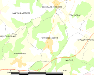
Сен-Ви (Saint-Vit, Saint-Vit)

- коммуна во Франции
 Hiking in Сен-Ви
Saint-Vit, located in the Bourgogne-Franche-Comté region of France, offers a charming backdrop for hiking enthusiasts. While it may not be as widely known as some larger hiking destinations in the country, the surrounding areas provide beautiful landscapes and trails that can be enjoyed. Here are some aspects to consider when hiking in and around Saint-Vit:
Trails and Scenery:
-
Countryside Paths: The region around Saint-Vit is characterized by rolling hills, fields, and woodlands, which provide plenty of opportunities for leisurely hikes. You can find well-marked paths that lead through picturesque scenery.
-
Nearby Parks and Nature Reserves: Explore nearby nature reserves, such as the Parc Naturel Régional du Haut-Jura, which is a bit further out but well worth the trip for its remarkable landscapes and diverse wildlife, including a network of trails suitable for various skill levels.
-
Historical Landmarks: Depending on your route, you may encounter local historical sites and charming villages, which can add to the experience. Discovering local culture and history can be a rewarding part of your hike.
Best Times to Hike:
- Spring and Autumn: These seasons typically offer the most comfortable temperatures and vibrant natural colors. Spring blooms and autumn foliage can greatly enhance your hiking experience.
- Summer: While it's a popular time for hiking, be prepared for warmer temperatures. Start your hikes early in the day to avoid the heat.
Tips for Hiking in Saint-Vit:
-
Map and Navigation: Always carry a map or a GPS device, as trail markers can sometimes be sparse. Familiarize yourself with the route beforehand.
-
Appropriate Gear: Wear sturdy hiking boots, dress in layers to adapt to changing weather, and pack sufficient water and snacks.
-
Stay Safe: Let someone know your hiking plans, especially if you're exploring less populated trails. It's always good practice to hike with a buddy.
-
Respect Nature: Follow Leave No Trace principles to preserve the beauty of the landscape for future hikers.
Local Amenities:
After a day on the trails, you can enjoy local cuisine in Saint-Vit or nearby towns, with options that highlight the culinary traditions of the Bourgogne-Franche-Comté region, including local cheeses and wines.
By planning your hike carefully and respecting the natural surroundings, you can make the most of your hiking experience in and around Saint-Vit. Happy hiking!
- Страна:

- Почтовый код: 25410
- Координаты: 47° 10' 53" N, 5° 48' 39" E


- GPS треки (wikiloc): [Ссылка]
- Площадь: 16.44 кв.км
- Население: 4833
- Веб сайт: http://www.saintvit.fr
- Википедия английская: wiki(en)
- Википедия национальная: wiki(fr)
- Хранилище Wikidata: Wikidata: Q906399
- Катеория в википедии: [Ссылка]
- код Freebase: [/m/03mgxtj]
- код Freebase: [/m/03mgxtj]
- код GeoNames: Альт: [2976579]
- код GeoNames: Альт: [2976579]
- номер SIREN: [212505275]
- номер SIREN: [212505275]
- код BNF: [152527537]
- код BNF: [152527537]
- код VIAF: Альт: [159612488]
- код VIAF: Альт: [159612488]
- код LCNAF: Альт: [n96094950]
- код LCNAF: Альт: [n96094950]
- код тезауруса PACTOLS: [pcrtw7D5DZnli2]
- код тезауруса PACTOLS: [pcrtw7D5DZnli2]
- место в MusicBrainz: [d29b4762-510f-4459-a592-314a728d05d3]
- место в MusicBrainz: [d29b4762-510f-4459-a592-314a728d05d3]
- код муниципалитета INSEE: 25527
- код муниципалитета INSEE: 25527
Граничит с регионами:


Évans
- коммуна во Франции
Hiking in Évans
Évans, also known as Évans Ridge, is a beautiful area that offers a variety of hiking opportunities, particularly noted for its scenic views and diverse terrain. Nestled in a region with rich natural beauty, hiking here can provide both tranquil and exhilarating experiences....
- Страна:
- Почтовый код: 39700
- Координаты: 47° 10' 44" N, 5° 46' 23" E
- GPS треки (wikiloc): [Ссылка]
- Площадь: 9.87 кв.км
- Население: 637


Roset-Fluans
- коммуна во Франции
Hiking in Roset-Fluans
Roset-Fluans is a charming commune located in the Doubs department in the Bourgogne-Franche-Comté region of France. It's nestled in the picturesque Jura mountains, which provide excellent opportunities for hiking and enjoying the outdoors....
- Страна:
- Почтовый код: 25410
- Координаты: 47° 9' 48" N, 5° 49' 33" E
- GPS треки (wikiloc): [Ссылка]
- Высота над уровнем моря: 260 м m
- Площадь: 8.28 кв.км
- Население: 507


Dannemarie-sur-Crète
- коммуна во Франции
Hiking in Dannemarie-sur-Crète
Dannemarie-sur-Crète is a charming small village located in the Bourgogne-Franche-Comté region of eastern France. The area is known for its picturesque landscapes, rolling hills, and natural beauty, making it a great destination for hiking enthusiasts....
- Страна:
- Почтовый код: 25410
- Координаты: 47° 12' 22" N, 5° 51' 56" E
- GPS треки (wikiloc): [Ссылка]
- Площадь: 4.06 кв.км
- Население: 1411


Salans
- коммуна во Франции
Hiking in Salans
Salans, located in the Jura region of France, offers a variety of hiking opportunities that allow you to experience the scenic beauty and unique landscapes of the area. Here are some highlights and tips for hiking in and around Salans:...
- Страна:
- Почтовый код: 39700
- Координаты: 47° 9' 53" N, 5° 47' 32" E
- GPS треки (wikiloc): [Ссылка]
- Площадь: 6.88 кв.км
- Население: 574


Routelle
- коммуна во Франции
Hiking in Routelle
Routelle, situated in the French Alps, is a fantastic destination for hiking enthusiasts. The region is characterized by its stunning landscapes, diverse flora and fauna, and a variety of trails suitable for all skill levels. Here are some key points to consider when planning a hike in Routelle:...
- Страна:
- Почтовый код: 25410
- Координаты: 47° 10' 4" N, 5° 50' 59" E
- GPS треки (wikiloc): [Ссылка]
- Площадь: 3.06 кв.км
- Население: 501


Berthelange
- коммуна во Франции
Hiking in Berthelange
Berthelange, a charming location in France, offers beautiful hiking opportunities for nature enthusiasts. While specific trails may not be world-renowned, the area is likely characterized by picturesque landscapes and local charm typical of French countryside hiking experiences....
- Страна:
- Почтовый код: 25410
- Координаты: 47° 11' 52" N, 5° 46' 46" E
- GPS треки (wikiloc): [Ссылка]
- Площадь: 4.07 кв.км
- Население: 309


Corcondray
- коммуна во Франции
Hiking in Corcondray
Corcondray isn't a well-known hiking destination, and there might be some confusion about the name. It’s possible you meant a different location, as this name doesn’t correspond to any widely recognized hiking area. However, if you are referring to a specific region or are looking for hiking in a related area, I’d be happy to help!...
- Страна:
- Почтовый код: 25410
- Координаты: 47° 13' 51" N, 5° 49' 32" E
- GPS треки (wikiloc): [Ссылка]
- Площадь: 5.38 кв.км
- Население: 144

Velesmes-Essarts
- коммуна во Франции
Hiking in Velesmes-Essarts
Velesmes-Essarts is a charming small commune located in the Doubs department of France. While it may not be as widely known for hiking as some larger regions, it offers an array of beautiful landscapes, lush forests, and scenic routes that are quite appealing to outdoor enthusiasts....
- Страна:
- Почтовый код: 25410
- Координаты: 47° 11' 28" N, 5° 52' 29" E
- GPS треки (wikiloc): [Ссылка]
- Площадь: 2.92 кв.км
- Население: 338


Pouilley-Français
- коммуна во Франции
Hiking in Pouilley-Français
Pouilley-Français, a charming village located in the Doubs department of the Bourgogne-Franche-Comté region in eastern France, offers a wonderful opportunity for hiking enthusiasts. The surrounding landscape features rolling hills, wooded areas, and picturesque countryside, making it a great spot for outdoor activities....
- Страна:
- Почтовый код: 25410
- Координаты: 47° 12' 26" N, 5° 50' 40" E
- GPS треки (wikiloc): [Ссылка]
- Площадь: 6.08 кв.км
- Население: 819

Ferrières-les-Bois
- коммуна во Франции
Hiking in Ferrières-les-Bois
Ferrières-les-Bois is a charming village located in the Jura region of France, ideal for hiking enthusiasts. The area is known for its stunning natural landscapes, including lush forests, rolling hills, and scenic vistas....
- Страна:
- Почтовый код: 25410
- Координаты: 47° 12' 16" N, 5° 48' 11" E
- GPS треки (wikiloc): [Ссылка]
- Площадь: 4.17 кв.км
- Население: 318