Сент-Аньес (Sainte-Agnès, Sainte-Agnès)
- коммуна в департаменте Приморские Альпы, регион Прованс — Альпы — Лазурный Берег, Франция
 Hiking in Сент-Аньес
Sainte-Agnès, located in the Alpes-Maritimes region of France, is a charming hilltop village that offers stunning views of the surrounding landscape, including the Mediterranean Sea. It is known for its rich history, picturesque streets, and a variety of hiking trails that cater to different skill levels.
Hiking Opportunities
-
Scenic Trails: The area around Sainte-Agnès features numerous well-marked hiking trails, many of which provide breathtaking panoramic views of the coast and the nearby mountains. Most trails are suitable for both beginners and experienced hikers.
-
Sentier des Douaniers (Customs Trail): This coastal path is popular among hikers for its dramatic views of the sea and cliffs. It stretches from the border with Italy to the French Riviera and can be accessed from nearby areas, offering a unique hiking experience along the coast.
-
Mont Agel: Considered a moderately challenging hike, Mont Agel is a peak near Sainte-Agnès. The trail leading up to it offers a rewarding view from the summit and leads hikers through beautiful Mediterranean vegetation.
-
Historical Routes: Explore trails that lead to historical sites such as Fort de la Revère or remnants of old stone bridges and medieval structures scattered throughout the area.
-
Flora and Fauna: The hiking trails are surrounded by diverse flora and fauna. Keep an eye out for local wildlife, and take the opportunity to learn about the region's natural biodiversity.
Preparation Tips
-
Season: The best time for hiking in this region is typically during spring (April to June) and autumn (September to October) when the temperatures are mild, and the scenery is particularly beautiful.
-
Proper Gear: Always wear sturdy hiking shoes and consider carrying trekking poles for uneven terrain. A hat, sunscreen, and plenty of water are also essential.
-
Maps and Guides: While many trails are marked, it’s wise to have a detailed map or a GPS device. Local visitor centers may offer maps and guidance.
-
Wildlife and Nature: Be respectful of the local wildlife and plants. Stick to marked trails to minimize your impact on the environment.
Conclusion
Hiking in Sainte-Agnès not only provides physical activity but also an opportunity to immerse yourself in the stunning natural beauty and rich history of the Alpes-Maritimes region. Whether you're looking for a leisurely walk or a more challenging hike, there's something for everyone. Enjoy your adventure!
- Страна:

- Почтовый код: 06500
- Координаты: 43° 47' 21" N, 7° 28' 9" E


- GPS треки (wikiloc): [Ссылка]
- Площадь: 9.37 кв.км
- Население: 1214
- Википедия русская: wiki(ru)
- Википедия английская: wiki(en)
- Википедия национальная: wiki(fr)
- Хранилище Wikidata: Wikidata: Q155413
- Катеория в википедии: [Ссылка]
- код Freebase: [/m/03m5b81]
- код Freebase: [/m/03m5b81]
- код GeoNames: Альт: [6425669]
- код GeoNames: Альт: [6425669]
- номер SIREN: [210601134]
- номер SIREN: [210601134]
- код VIAF: Альт: [261511795]
- код VIAF: Альт: [261511795]
- код тезауруса PACTOLS: [pcrtTtFcfwepiP]
- код тезауруса PACTOLS: [pcrtTtFcfwepiP]
- код муниципалитета INSEE: 06113
- код муниципалитета INSEE: 06113
Граничит с регионами:

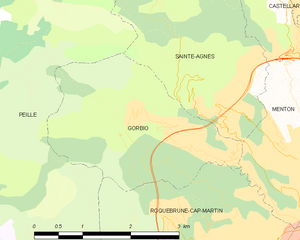
Горбьо
- коммуна в департаменте Приморские Альпы, регион Прованс — Альпы — Лазурный Берег, Франция
Hiking in Горбьо
Gorbio is a charming village located in the Alpes-Maritimes department in the Provence-Alpes-Côte d'Azur region of southeastern France. Nestled in the foothills of the French Alps, Gorbio offers a unique blend of stunning landscapes, cultural heritage, and hiking opportunities....
- Страна:
- Почтовый код: 06500
- Координаты: 43° 47' 12" N, 7° 26' 42" E
- GPS треки (wikiloc): [Ссылка]
- Площадь: 7.02 кв.км
- Население: 1387
- Веб сайт: [Ссылка]

Ментона
- коммуна в департаменте Приморские Альпы, регион Прованс — Альпы — Лазурный Берег, Франция
- Страна:
- Почтовый код: 06500
- Код автомобильного номера: 06
- Координаты: 43° 46' 29" N, 7° 29' 59" E
- GPS треки (wikiloc): [Ссылка]
- Высота над уровнем моря: 16 м m
- Площадь: 14.05 кв.км
- Население: 28231
- Веб сайт: [Ссылка]


Кастийон
- коммуна в департаменте Приморские Альпы, регион Прованс — Альпы — Лазурный Берег, Франция
Hiking in Кастийон
Hiking in Castillon, Alpes-Maritimes, offers a unique blend of stunning landscapes, Mediterranean climate, and rich natural biodiversity. Nestled in the foothills of the French Riviera, Castillon is known for its picturesque views, quaint village charm, and a variety of hiking trails suitable for all levels of experience....
- Страна:
- Почтовый код: 06500
- Координаты: 43° 50' 0" N, 7° 28' 20" E
- GPS треки (wikiloc): [Ссылка]
- Площадь: 7.51 кв.км
- Население: 378
- Веб сайт: [Ссылка]

Пей
- коммуна в департаменте Приморские Альпы, регион Прованс — Альпы — Лазурный Берег, Франция
Hiking in Пей
Peille is a charming village located in the Alpes-Maritimes department in the Provence-Alpes-Côte d'Azur region of France. Nestled in the hills above the Mediterranean, it offers a variety of hiking opportunities with stunning views, lush vegetation, and a rich history....
- Страна:
- Почтовый код: 06440
- Координаты: 43° 48' 9" N, 7° 24' 6" E
- GPS треки (wikiloc): [Ссылка]
- Площадь: 43.16 кв.км
- Население: 2353
- Веб сайт: [Ссылка]