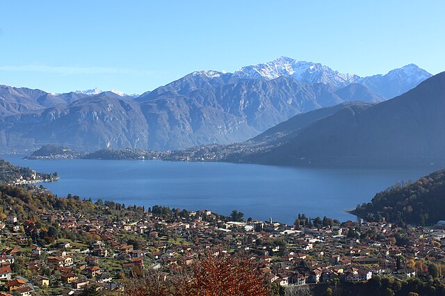
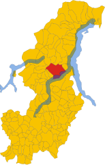
Сала-Комачина (Sala Comacina, Sala Comacina)
.svg)
- коммуна Италии
 Hiking in Сала-Комачина
Sala Comacina is a picturesque small town located on the western shore of Lake Como in Italy. It offers opportunities for hiking enthusiasts to explore the stunning natural landscapes and enjoy scenic views of the lake and surrounding mountains. Here are some key highlights and tips for hiking in Sala Comacina:
Hiking Trails
-
Sentiero del Viandante: This historical path stretches along the eastern shore of Lake Como but can be accessed from nearby locations. While not directly in Sala Comacina, it's a well-known trail that offers beautiful views and connects various towns along the lake.
-
Cernobbio and Brunate: If you are looking for a more challenging hike, consider heading toward nearby Cernobbio, which offers trails leading to Brunate, a charming village above Como. The trail provides breathtaking views of the lake and the surrounding area.
-
Trail to San Benedetto: This hike leads to the church of San Benedetto, situated above Sala Comacina. It’s a relatively short hike that rewards you with panoramic views of the lake and surrounding mountains.
-
Mount San Primo: For adventurous hikers looking to tackle higher elevations, Mount San Primo is a popular destination just a short drive from Sala Comacina. The hike is a bit more demanding but offers fantastic vistas of the entire lake region from the summit.
Tips for Hiking in Sala Comacina
-
Best Time to Hike: The best seasons for hiking in this area are spring (April to June) and early autumn (September to October) when the weather is mild, and the scenery is beautiful.
-
Safety: Always check the weather conditions before heading out and be prepared for changing conditions in the mountains. Wear appropriate hiking gear, and always carry enough water and snacks.
-
Local Regulations: Respect local wildlife and adhere to any specific regulations regarding trail use, especially in protected areas.
-
Map and Compass: Make sure to have a map of the area or a GPS device. Some trails may not be well marked.
-
Public Transport: Sala Comacina is accessible via public transport from Como, making it easy to reach the hiking starting points without a car.
-
Local Advice: Don't hesitate to ask locals for advice on trails. They can provide invaluable insight into conditions and hidden gems!
Hiking in Sala Comacina can be a delightful experience, combining physical activity with the enjoyment of beautiful landscapes and the rich history of the region. Make sure to take your time and enjoy the sights along the way!
- Страна:

- Почтовый код: 22010
- Телефонный код: 0344
- Код автомобильного номера: CO
- Координаты: 45° 58' 0" N, 9° 10' 0" E


- GPS треки (wikiloc): [Ссылка]
- Высота над уровнем моря: 213 м m
- Площадь: 4.73 кв.км
- Население: 538
- Веб сайт: http://www.salacomacina.com/
- Википедия русская: wiki(ru)
- Википедия английская: wiki(en)
- Википедия национальная: wiki(it)
- Хранилище Wikidata: Wikidata: Q47610
- Катеория в википедии: [Ссылка]
- код Freebase: [/m/0gj1pd]
- код GeoNames: Альт: [6542513]
- код VIAF: Альт: [234369601]
- ID отношения в OpenStreetMap: [46587]
- идентификатор местоположения ArchINFORM: [14760]
- код ISTAT: 013203
- кадастровый код Италии: H679
Граничит с регионами:
Tremezzina
Hiking in Tremezzina
Tremezzina is a picturesque area located on the western shore of Lake Como in Italy. It consists of several charming towns, including Tremezzo, Lenno, and Mezzegra, all surrounded by stunning landscapes, lush greenery, and breathtaking views of the lake and the surrounding mountains. Here are some highlights about hiking in Tremezzina:...
- Страна:
- Почтовый код: 22016
- Телефонный код: 0344
- Код автомобильного номера: CO
- Координаты: 45° 58' 51" N, 9° 12' 10" E
- GPS треки (wikiloc): [Ссылка]
- Высота над уровнем моря: 200 м m
- Площадь: 29.41 кв.км
- Население: 5118
- Веб сайт: [Ссылка]
Колонно
- коммуна Италии
Hiking in Колонно
Colonno is a beautiful village located on the western shore of Lake Como in Italy, known for its stunning scenery and charming architecture. Hiking around Colonno offers a mix of breathtaking views, historical sites, and opportunities to experience the natural beauty of the region....
- Страна:
- Почтовый код: 22010
- Телефонный код: 031
- Код автомобильного номера: CO
- Координаты: 45° 57' 28" N, 9° 9' 20" E
- GPS треки (wikiloc): [Ссылка]
- Высота над уровнем моря: 215 м m
- Площадь: 5.62 кв.км
- Население: 508
- Веб сайт: [Ссылка]
Леццено
- коммуна Италии
Hiking in Леццено
Lezzeno is a picturesque village located on the eastern shore of Lake Como in Italy. It offers stunning views and a range of beautiful hiking opportunities, attracting both beginners and experienced hikers. Here are some highlights for hiking in and around Lezzeno:...
- Страна:
- Почтовый код: 22025
- Телефонный код: 031
- Код автомобильного номера: CO
- Координаты: 45° 57' 0" N, 9° 12' 0" E
- GPS треки (wikiloc): [Ссылка]
- Высота над уровнем моря: 202 м m
- Площадь: 20.7 кв.км
- Население: 2095
- Веб сайт: [Ссылка]


Понна
- коммуна Италии
Hiking in Понна
Ponna is not a well-known hiking destination, so it could refer to a lesser-known area or a typo for a more popular hiking location. However, if you meant a specific place such as a region or park that might be popular for hiking, please clarify!...
- Страна:
- Почтовый код: 22020
- Телефонный код: 031
- Код автомобильного номера: CO
- Координаты: 45° 59' 0" N, 9° 6' 0" E
- GPS треки (wikiloc): [Ссылка]
- Высота над уровнем моря: 870 м m
- Площадь: 5.81 кв.км
- Население: 239
- Веб сайт: [Ссылка]