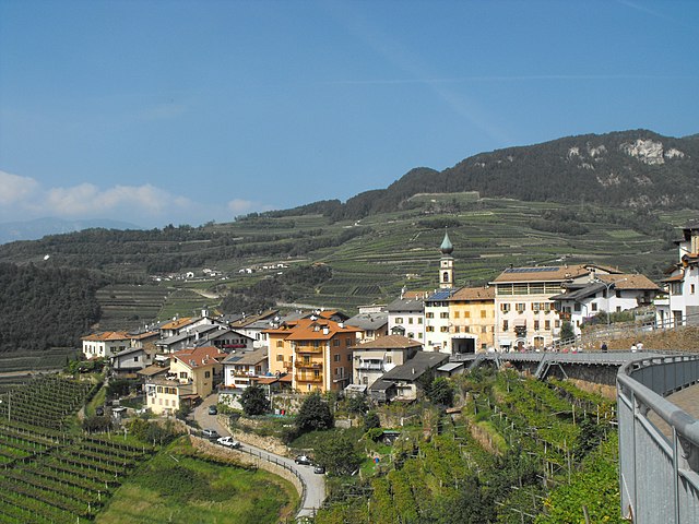
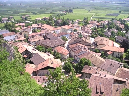
Салорно (Salorno, Salorno)
.svg)
- коммуна в Италии
 Hiking in Салорно
Salorno, known as Salurn in German, is a picturesque village located in South Tyrol, Italy. It is nestled at the edge of the Adige Valley and serves as an excellent starting point for various hiking trails that showcase the region's stunning natural beauty.
Hiking Highlights in Salorno:
-
Trails and Routes:
- Adige Path (Adhigelweg): This long-distance trail follows the River Adige and offers a pleasant hike with beautiful views of the surrounding vineyards and mountains.
- Cima di zocca: A challenging hike that rewards you with panoramic views at the summit. The trail takes you through lush forests and rocky terrain.
- Kaltern Hiking Area: A short drive from Salorno, this area has numerous trails that vary in difficulty, offering unique views of Lake Kaltern and the surrounding countryside.
-
Scenic Views: Hikers in Salorno are treated to breathtaking views of the Dolomites and the surrounding valleys. The diverse landscape offers something for everyone, from gentle slopes for beginners to more demanding climbs for experienced hikers.
-
Flora and Fauna: The region is rich in biodiversity, with various species of plants and wildlife. Keep an eye out for local bird species and unique flora along the trails.
-
Cultural Points of Interest: On your hikes, you may encounter traditional Tyrolean architecture and historical landmarks, such as old churches and farmhouses, providing insight into the local culture and history.
-
Accessibility: Salorno is easily accessible from larger cities like Bolzano or Trento, making it a convenient base for both day hikes and longer excursions in the surrounding areas.
Tips for Hiking in Salorno:
- Trail Maps: Always carry a map or a GPS device, as trails can vary in marking.
- Check Weather Conditions: The weather can change rapidly in the mountains, so be prepared with the right gear.
- Hydrate and Snack: Bring enough water and snacks, especially for longer hikes.
- Respect Nature: Follow Leave No Trace principles to preserve the natural beauty of the area.
Whether you’re a seasoned hiker or a casual walker, Salorno offers a range of hiking opportunities that allow you to explore the stunning natural landscape and cultural heritage of South Tyrol.
- Страна:

- Почтовый код: 39040
- Телефонный код: 0471
- Код автомобильного номера: BZ
- Координаты: 46° 14' 0" N, 11° 12' 0" E


- GPS треки (wikiloc): [Ссылка]
- Высота над уровнем моря: 224 м m
- Площадь: 33.13 кв.км
- Население: 3842
- Веб сайт: http://www.comune.salorno.bz.it
- Википедия русская: wiki(ru)
- Википедия английская: wiki(en)
- Википедия национальная: wiki(it)
- Хранилище Wikidata: Wikidata: Q258810
- Галерея изображений в википедии: [Ссылка]
- Катеория в википедии: [Ссылка]
- код Freebase: [/m/0g9j7k]
- код GeoNames: Альт: [6535958]
- код VIAF: Альт: [236837851]
- ID отношения в OpenStreetMap: [47045]
- код GND: Альт: [4105239-0]
- UN/LOCODE: [ITSLN]
- код Цифрового атласа Римской империи: [16645]
- код Pleiades: [187536]
- код ISTAT: 021076
- кадастровый код Италии: H719
Граничит с регионами:


Каприана
- коммуна Италии
Hiking in Каприана
Capriana is a beautiful destination in the Trentino region of Italy that offers a variety of hiking opportunities characterized by stunning natural landscapes, rich flora and fauna, and panoramic views of the surrounding mountains and valleys. Here are some key points to consider when planning a hiking excursion in Capriana:...
- Страна:
- Почтовый код: 38030
- Телефонный код: 0462
- Код автомобильного номера: TN
- Координаты: 46° 16' 0" N, 11° 20' 0" E
- GPS треки (wikiloc): [Ссылка]
- Высота над уровнем моря: 1007 м m
- Площадь: 12.82 кв.км
- Население: 589
- Веб сайт: [Ссылка]

Джово
- коммуна Италии
Hiking in Джово
Giovo, located in the Trentino region of northern Italy, offers a variety of hiking opportunities that showcase the stunning natural beauty of the area. The terrain is characterized by picturesque landscapes, including rolling hills, lush forests, and views of the surrounding mountains, making it an appealing destination for both novice and experienced hikers....
- Страна:
- Почтовый код: 38030
- Телефонный код: 0461
- Код автомобильного номера: TN
- Координаты: 46° 9' 21" N, 11° 9' 10" E
- GPS треки (wikiloc): [Ссылка]
- Высота над уровнем моря: 495 м m
- Площадь: 20.81 кв.км
- Население: 2521
- Веб сайт: [Ссылка]


Меццокорона
- коммуна Италии
Hiking in Меццокорона
Mezzocorona, located in the Trentino region of northern Italy, offers beautiful hiking opportunities amid stunning landscapes, vineyards, and the backdrop of the Dolomite Mountains. Here are some key details about hiking in the area:...
- Страна:
- Почтовый код: 38016
- Телефонный код: 0461
- Код автомобильного номера: TN
- Координаты: 46° 13' 0" N, 11° 7' 0" E
- GPS треки (wikiloc): [Ссылка]
- Высота над уровнем моря: 200 м m
- Площадь: 25.35 кв.км
- Население: 5477
- Веб сайт: [Ссылка]
Ровере-делла-Луна
- коммуна Италии
Hiking in Ровере-делла-Луна
Roveré della Luna, located in the Trentino region of northern Italy, is a charming destination for outdoor enthusiasts and hikers. Nestled in the picturesque landscape of the Adige Valley, the area is surrounded by lush forests, rolling hills, and stunning mountain vistas, making it a great spot for a wide range of hiking experiences....
- Страна:
- Почтовый код: 38030
- Телефонный код: 0461
- Код автомобильного номера: TN
- Координаты: 46° 15' 0" N, 11° 10' 0" E
- GPS треки (wikiloc): [Ссылка]
- Высота над уровнем моря: 251 м m
- Площадь: 10.41 кв.км
- Население: 1643
- Веб сайт: [Ссылка]


Кортина-сулла-Страда-дель-Вино
- коммуна Италии
Hiking in Кортина-сулла-Страда-дель-Вино
Kurtinig an der Weinstraße, located in South Tyrol, Italy, is a beautiful destination for hikers and outdoor enthusiasts. Nestled in a picturesque valley surrounded by vineyards and rolling hills, it offers a variety of hiking opportunities suitable for all levels of experience....
- Страна:
- Почтовый код: 39040
- Телефонный код: 0471
- Код автомобильного номера: BZ
- Координаты: 46° 16' 10" N, 11° 13' 19" E
- GPS треки (wikiloc): [Ссылка]
- Высота над уровнем моря: 212 м m
- Площадь: 2 кв.км
- Население: 664
- Веб сайт: [Ссылка]


Энья
- коммуна Италии
Hiking in Энья
Neumarkt (or Egna in Italian) is a charming town located in South Tyrol, Italy, nestled in the picturesque Adige Valley. This region is surrounded by stunning landscapes, mountains, and vineyards, making it an excellent destination for hiking enthusiasts. Here are some highlights and tips for hiking in the area:...
- Страна:
- Почтовый код: 39044
- Телефонный код: 0471
- Код автомобильного номера: BZ
- Координаты: 46° 19' 4" N, 11° 16' 24" E
- GPS треки (wikiloc): [Ссылка]
- Высота над уровнем моря: 214 м m
- Площадь: 23.57 кв.км
- Население: 5278
- Веб сайт: [Ссылка]

Магре-сулла-Страда-дель-Вино
- коммуна Италии
Hiking in Магре-сулла-Страда-дель-Вино
Margreid an der Weinstraße, located in South Tyrol, Italy, is a picturesque village that offers a great base for hiking enthusiasts. This region is known for its vineyards, beautiful landscapes, and charming views of the surrounding mountains, making it an ideal destination for outdoor activities....
- Страна:
- Почтовый код: 39040
- Телефонный код: 0471
- Код автомобильного номера: BZ
- Координаты: 46° 17' 16" N, 11° 12' 38" E
- GPS треки (wikiloc): [Ссылка]
- Высота над уровнем моря: 241 м m
- Площадь: 13.86 кв.км
- Население: 1295
- Веб сайт: [Ссылка]


Монтанья
- коммуна Италии
Hiking in Монтанья
Hiking in Montana offers some of the most stunning landscapes and diverse ecosystems in the United States. With its vast wilderness areas, national parks, and state parks, Montana is a hiker’s paradise. Here are some key highlights and considerations for hiking in Montana:...
- Страна:
- Почтовый код: 39040
- Телефонный код: 0471
- Код автомобильного номера: BZ
- Координаты: 46° 19' 49" N, 11° 18' 1" E
- GPS треки (wikiloc): [Ссылка]
- Высота над уровнем моря: 497 м m
- Площадь: 19.51 кв.км
- Население: 1684
- Веб сайт: [Ссылка]