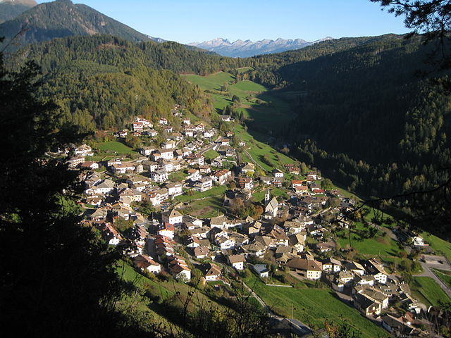
Каприана (Capriana, Capriana)
%202018.svg)
- коммуна Италии
 Hiking in Каприана
Capriana is a beautiful destination in the Trentino region of Italy that offers a variety of hiking opportunities characterized by stunning natural landscapes, rich flora and fauna, and panoramic views of the surrounding mountains and valleys. Here are some key points to consider when planning a hiking excursion in Capriana:
Hiking Trails
-
Difficulty Levels: Trails in Capriana cater to various skill levels, from easy walks suitable for families to challenging hikes for experienced trekkers.
-
Scenic Routes: Many trails in the area provide breathtaking views of the surrounding Dolomites, lush forests, and picturesque meadows. Popular routes may lead you through diverse ecosystems and charming villages.
-
Local Highlights: Look for trails that pass by local landmarks, such as historical sites, churches, and natural monuments.
Wildlife and Flora
- Capriana is home to diverse wildlife, and hikers may encounter various animal species, including deer, foxes, and a wide range of bird species.
- The region also boasts a rich variety of plant life, with wildflowers and unique alpine plants, especially during the spring and summer months.
Best Time to Hike
- Spring and Summer: The weather is generally mild, and trails are usually free from snow, making these seasons ideal for hiking.
- Autumn: Fall offers stunning foliage and less crowded trails, although temperatures can dip, so appropriate clothing is necessary.
Preparation
- Gear: Ensure you have proper hiking boots, weather-appropriate clothing, and supplies such as water, snacks, a map, and a first-aid kit.
- Navigation: While many trails are marked, consider bringing a map or GPS device, especially if you plan to explore less popular routes.
Local Resources
- Check in with local visitor centers or hiking clubs in Capriana for trail maps, advice on current trail conditions, and guided hikes if you're interested in learning more about the area.
Safety Tips
- Always inform someone about your hiking plans and expected return time.
- Be aware of the weather and prepared for changing conditions, especially in the mountains.
Whether you're looking for a peaceful stroll through nature or an adventurous trek, Capriana offers a beautiful setting for hikers of all levels. Enjoy your hiking adventure!
- Страна:

- Почтовый код: 38030
- Телефонный код: 0462
- Код автомобильного номера: TN
- Координаты: 46° 16' 0" N, 11° 20' 0" E


- GPS треки (wikiloc): [Ссылка]
- Высота над уровнем моря: 1007 м m
- Площадь: 12.82 кв.км
- Население: 589
- Веб сайт: http://www.comunecapriana.com/
- Википедия русская: wiki(ru)
- Википедия английская: wiki(en)
- Википедия национальная: wiki(it)
- Хранилище Wikidata: Wikidata: Q258135
- Катеория в википедии: [Ссылка]
- код Freebase: [/m/0g9ycf]
- код GeoNames: Альт: [6536232]
- ID отношения в OpenStreetMap: [47064]
- код ISTAT: 022040
- кадастровый код Италии: B697
Граничит с регионами:
Кастелло-Молина-ди-Фьемме
- коммуна Италии
Hiking in Кастелло-Молина-ди-Фьемме
Castello-Molina di Fiemme is a picturesque area located in the Val di Fiemme region of the Trentino-Alto Adige/Südtirol in northern Italy. It offers a range of hiking opportunities amid stunning landscapes characterized by lush meadows, dense forests, and impressive mountain scenery that is typical of the Dolomites....
- Страна:
- Почтовый код: 38030
- Телефонный код: 0462
- Код автомобильного номера: TN
- Координаты: 46° 16' 19" N, 11° 25' 2" E
- GPS треки (wikiloc): [Ссылка]
- Высота над уровнем моря: 900 м m
- Площадь: 54.56 кв.км
- Население: 2307
- Веб сайт: [Ссылка]


Салорно
- коммуна в Италии
Hiking in Салорно
Salorno, known as Salurn in German, is a picturesque village located in South Tyrol, Italy. It is nestled at the edge of the Adige Valley and serves as an excellent starting point for various hiking trails that showcase the region's stunning natural beauty....
- Страна:
- Почтовый код: 39040
- Телефонный код: 0471
- Код автомобильного номера: BZ
- Координаты: 46° 14' 0" N, 11° 12' 0" E
- GPS треки (wikiloc): [Ссылка]
- Высота над уровнем моря: 224 м m
- Площадь: 33.13 кв.км
- Население: 3842
- Веб сайт: [Ссылка]


Совер
- коммуна Италии
Hiking in Совер
Sover, located in the state of Vermont, offers a variety of hiking opportunities that cater to different skill levels and preferences. Here are some key details about hiking in and around Sover:...
- Страна:
- Почтовый код: 38048
- Телефонный код: 0461
- Код автомобильного номера: TN
- Координаты: 46° 13' 0" N, 11° 19' 0" E
- GPS треки (wikiloc): [Ссылка]
- Высота над уровнем моря: 854 м m
- Площадь: 14.82 кв.км
- Население: 824
- Веб сайт: [Ссылка]


Вальфлориана
- коммуна Италии
Hiking in Вальфлориана
Valfloriana is a picturesque area located in the Trentino region of northern Italy, known for its stunning landscapes, rich biodiversity, and charming villages. Hiking in Valfloriana offers a fantastic experience for outdoor enthusiasts, with a variety of trails suitable for different skill levels....
- Страна:
- Почтовый код: 38040
- Телефонный код: 0462
- Код автомобильного номера: TN
- Координаты: 46° 15' 0" N, 11° 21' 0" E
- GPS треки (wikiloc): [Ссылка]
- Высота над уровнем моря: 853 м m
- Площадь: 39.33 кв.км
- Население: 470
- Веб сайт: [Ссылка]


Антериво
- коммуна Италии
Hiking in Антериво
Altrei is a charming village located in the South Tyrol region of northern Italy. It is surrounded by stunning natural landscapes, making it a great destination for hiking enthusiasts. Here are some key points about hiking in Altrei:...
- Страна:
- Почтовый код: 39040
- Телефонный код: 0471
- Код автомобильного номера: BZ
- Координаты: 46° 16' 41" N, 11° 22' 0" E
- GPS треки (wikiloc): [Ссылка]
- Высота над уровнем моря: 1635 м m
- Площадь: 11.06 кв.км
- Население: 396
- Веб сайт: [Ссылка]


Монтанья
- коммуна Италии
Hiking in Монтанья
Hiking in Montana offers some of the most stunning landscapes and diverse ecosystems in the United States. With its vast wilderness areas, national parks, and state parks, Montana is a hiker’s paradise. Here are some key highlights and considerations for hiking in Montana:...
- Страна:
- Почтовый код: 39040
- Телефонный код: 0471
- Код автомобильного номера: BZ
- Координаты: 46° 19' 49" N, 11° 18' 1" E
- GPS треки (wikiloc): [Ссылка]
- Высота над уровнем моря: 497 м m
- Площадь: 19.51 кв.км
- Население: 1684
- Веб сайт: [Ссылка]

Тродена-нель-парко-натурале
- коммуна в Италии
Hiking in Тродена-нель-парко-натурале
Truden im Naturpark, located in the South Tyrol region of northern Italy, is a beautiful destination for hiking enthusiasts. It is nestled within the larger Rosengarten-Latemar Nature Park, which offers diverse landscapes, including lush forests, meadows, and stunning mountain views....
- Страна:
- Почтовый код: 39040
- Телефонный код: 0471
- Код автомобильного номера: BZ
- Координаты: 46° 19' 19" N, 11° 20' 59" E
- GPS треки (wikiloc): [Ссылка]
- Высота над уровнем моря: 719 м m
- Площадь: 20.56 кв.км
- Население: 1027
- Веб сайт: [Ссылка]