
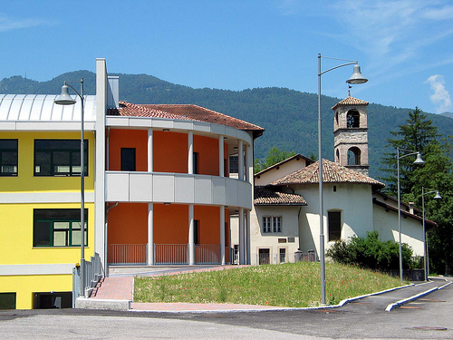
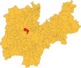
Сан-Лоренцо-ин-Банале (San Lorenzo in Banale, San Lorenzo in Banale)
- коммуна Италии
 Hiking in Сан-Лоренцо-ин-Банале
San Lorenzo in Banale is a picturesque village located in the Trentino region of northern Italy, surrounded by the stunning natural beauty of the Brenta Dolomites. This area offers a variety of hiking opportunities for all skill levels, making it a popular destination for outdoor enthusiasts. Here are some key highlights about hiking in and around San Lorenzo in Banale:
1.
- Valle del Limarò: This area features several trails that take you through lush forests, along rivers, and up to panoramic viewpoints. The trail can lead to stunning vistas of the Brenta Dolomites.
- Sentiero del Monte Rovese: A relatively easy hike that offers beautiful views of the surrounding valleys and mountains, suitable for families and beginners.
- Doss del Sabion: If you're looking for a more challenging hike, consider the trails leading to Doss del Sabion, known for its breathtaking views.
2.
- The region is rich in diverse ecosystems, with opportunities to spot various wildlife, including deer, chamois, and numerous bird species. The flora includes a variety of wildflowers, especially in spring and early summer.
3.
- As you hike, you may encounter ancient churches, traditional farms, and local structures that reflect the rich history and culture of the Trentino region.
4.
- Spring and Summer: These seasons provide the best hiking conditions, with trails being accessible and wildflowers in bloom.
- Autumn: The fall foliage offers a spectacular backdrop, but be mindful of weather changes.
- Winter: While many trails may be difficult to navigate due to snow, winter hiking and snowshoeing are popular alternatives in the area.
5.
- San Lorenzo in Banale offers various accommodations, including hotels, guesthouses, and agriturismos, allowing you to relax after a day of hiking. Local restaurants serve traditional Trentino cuisine, providing an excellent way to refuel.
6.
- For those who prefer a structured experience, consider hiring a local guide who can lead hikes and provide insights into the area's natural history and cultural heritage.
7.
- Always check the weather conditions before heading out.
- Make sure to carry enough water, snacks, and appropriate gear (hiking boots, layers, map, etc.).
- Respect wildlife and stay on marked trails.
San Lorenzo in Banale is a hidden gem for hikers seeking both adventure and tranquility amidst breathtaking landscapes. Whether you're a seasoned hiker or a beginner, you'll find the beauty of this area rewarding.
- Страна:

- Почтовый код: 38078
- Телефонный код: 0465
- Код автомобильного номера: TN
- Координаты: 46° 5' 0" N, 10° 55' 0" E


- GPS треки (wikiloc): [Ссылка]
- Высота над уровнем моря: 758 м m
- Площадь: 61.41 кв.км
- Веб сайт: http://www.comune.sanlorenzodorsino.tn.it/
- Википедия русская: wiki(ru)
- Википедия английская: wiki(en)
- Википедия национальная: wiki(it)
- Хранилище Wikidata: Wikidata: Q301790
- Катеория в википедии: [Ссылка]
- код Freebase: [/m/0gb0fc]
- код GeoNames: Альт: [6543544]
- код VIAF: Альт: [123001944]
- код ISTAT: 022166
- кадастровый код Италии: H966
Граничит с регионами:


Андало
- коммуна Италии
Hiking in Андало
Andalo is a beautiful village located in the Trentino region of northern Italy, surrounded by the scenic Dolomites. This area is a fantastic destination for hiking enthusiasts, offering a variety of trails that cater to all skill levels, from leisurely strolls to challenging alpine hikes. Here are some highlights of hiking in Andalo:...
- Страна:
- Почтовый код: 38010
- Телефонный код: 0461
- Код автомобильного номера: TN
- Координаты: 46° 10' 0" N, 11° 0' 16" E
- GPS треки (wikiloc): [Ссылка]
- Высота над уровнем моря: 1040 м m
- Площадь: 11.38 кв.км
- Население: 1102
- Веб сайт: [Ссылка]

Комано-Терме
- коммуна Италии
Hiking in Комано-Терме
Comano Terme, located in the Trentino region of northern Italy, is a beautiful destination known for its thermal baths and stunning natural scenery, making it an excellent spot for hiking enthusiasts. Nestled in the Brenta Dolomites, Comano Terme offers various trails that cater to different skill levels, from leisurely walks to challenging hikes....
- Страна:
- Почтовый код: 38077
- Телефонный код: 0465
- Код автомобильного номера: TN
- Координаты: 46° 10' 0" N, 10° 52' 0" E
- GPS треки (wikiloc): [Ссылка]
- Высота над уровнем моря: 400 м m
- Площадь: 68.11 кв.км
- Население: 2964
- Веб сайт: [Ссылка]

Дорсино
- коммуна Италии
Hiking in Дорсино
Dorsino is a picturesque village located in the Trentino region of northern Italy, nestled in the Sarca Valley near the Brenta Dolomites. This area offers incredible hiking opportunities, thanks to its stunning landscapes, diverse flora and fauna, and numerous trails suitable for various skill levels. Here are some key points about hiking in Dorsino:...
- Страна:
- Почтовый код: 38070
- Телефонный код: 0465
- Код автомобильного номера: TN
- Координаты: 46° 4' 23" N, 10° 53' 46" E
- GPS треки (wikiloc): [Ссылка]
- Высота над уровнем моря: 636 м m
- Площадь: 12.51 кв.км
- Веб сайт: [Ссылка]

Мольвено
- коммуна Италии
Hiking in Мольвено
Molveno, a picturesque village located in the Trentino region of northern Italy, is known for its stunning natural surroundings, making it an excellent destination for hiking enthusiasts. Nestled near the shores of Lake Molveno and at the foot of the Brenta Dolomites, visitors can enjoy a variety of hiking trails catering to all skill levels....
- Страна:
- Почтовый код: 38018
- Телефонный код: 0461
- Код автомобильного номера: TN
- Координаты: 46° 8' 35" N, 10° 57' 53" E
- GPS треки (wikiloc): [Ссылка]
- Высота над уровнем моря: 864 м m
- Площадь: 34.12 кв.км
- Население: 1123
- Веб сайт: [Ссылка]


Стенико
- коммуна Италии
Hiking in Стенико
Stenico, located in the Trentino region of northern Italy, offers a variety of beautiful hiking opportunities amidst stunning natural landscapes, including mountains, forests, and streams. Here are some highlights for hiking enthusiasts in the area:...
- Страна:
- Почтовый код: 38070
- Телефонный код: 0465
- Код автомобильного номера: TN
- Координаты: 46° 3' 0" N, 10° 51' 0" E
- GPS треки (wikiloc): [Ссылка]
- Высота над уровнем моря: 666 м m
- Площадь: 49.15 кв.км
- Население: 1186
- Веб сайт: [Ссылка]