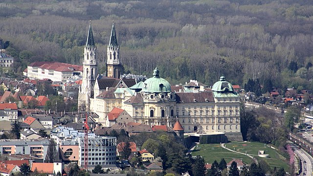
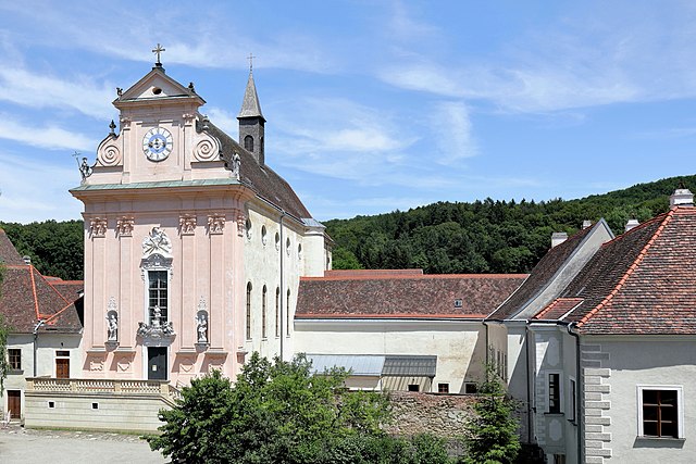
Санкт-Андре-Вёрдерн (Sankt Andrä-Wördern, St. Andrä-Wördern)
 Hiking in Санкт-Андре-Вёрдерн
Sankt Andrä-Wördern, located in Lower Austria, is a charming area situated near the Danube River, making it a great destination for hikers who appreciate picturesque landscapes, natural beauty, and a bit of cultural exploration. Here are some highlights to consider for hiking in the region:
Trails and Terrain
-
Danube Trail: This well-marked trail runs alongside the Danube River and offers stunning views of the riverbanks, lush forests, and nearby hills. It’s suitable for hikers of all levels and provides opportunities for shorter or longer hikes depending on your preference.
-
Budapest Trail: Another attractive trail runs through the scenic environment of the Vienna Woods (Wienerwald). It offers a variety of terrains, including gentle hills and shaded forests, ideal for both casual walkers and more seasoned hikers.
-
Local Trails: Explore smaller, local trails that lead you through the vineyards and fields surrounding Sankt Andrä-Wördern. These paths often provide a glimpse into the local flora and fauna and can be less crowded.
Natural Attractions
- Views of the Danube: Many trails offer beautiful vistas of the river, with opportunities to stop for picnics or enjoy the peaceful surroundings.
- Forest Areas: The nearby forests provide a shaded escape, ideal for warm-weather hikes. Look for spots to rest or enjoy the serenity of nature.
Tips for Hiking in Sankt Andrä-Wördern
- Best Time to Visit: Spring and autumn are generally the best seasons for hiking, as the weather is mild and the scenery is particularly beautiful during these times.
- Safety Precautions: Always check the weather forecast before heading out, wear appropriate footwear, and carry enough water and snacks, especially on longer hikes.
- Respect Nature: Stay on designated paths to minimize your environmental impact and follow the principles of Leave No Trace.
Getting There
Sankt Andrä-Wördern is accessible by public transport from Vienna, making it a convenient day trip for those in the city looking to escape into nature for a hike.
Whether you’re looking to enjoy a leisurely stroll along the river or tackle a more challenging trail in the nearby hills, Sankt Andrä-Wördern provides a lovely hiking experience with a mix of natural beauty and cultural sights.
- Страна:

- Почтовый код: 3423
- Телефонный код: 02242
- Код автомобильного номера: TU
- Координаты: 48° 19' 40" N, 16° 12' 34" E


- GPS треки (wikiloc): [Ссылка]
- Высота над уровнем моря: 177 м m
- Площадь: 39.37 кв.км
- Население: 7870
- Веб сайт: http://www.staw.at/
- Википедия русская: wiki(ru)
- Википедия английская: wiki(en)
- Википедия национальная: wiki(de)
- Хранилище Wikidata: Wikidata: Q672587
- Катеория в википедии: [Ссылка]
- код Freebase: [/m/03gs5yd]
- код GeoNames: Альт: [7873041]
- код VIAF: Альт: [126814769]
- код GND: Альт: [4314467-6]
- идентификатор местоположения ArchINFORM: [10215]
- код LCNAF: Альт: [n93015406]
- место в MusicBrainz: [530e9384-2869-4d06-85fb-9dd754323643]
- код австрийского муниципалитета: [32142]
Граничит с регионами:

Цайзельмауэр-Вольфпассинг
Hiking in Цайзельмауэр-Вольфпассинг
Zeiselmauer-Wolfpassing is a picturesque area located in Lower Austria, known for its beautiful landscapes and accessibility for both casual and experienced hikers. Here are some highlights and tips for hiking in this region:...
- Страна:
- Почтовый код: 3424
- Телефонный код: 02242
- Код автомобильного номера: TU
- Координаты: 48° 19' 10" N, 16° 10' 30" E
- GPS треки (wikiloc): [Ссылка]
- Высота над уровнем моря: 175 м m
- Площадь: 12.7 кв.км
- Население: 2302
- Веб сайт: [Ссылка]

Клостернойбург
Hiking in Клостернойбург
Klosterneuburg, located just north of Vienna, Austria, offers a variety of beautiful hiking trails that cater to different skill levels and preferences. The region is characterized by its picturesque landscapes, historical sites, and proximity to the Vienna Woods (Wienerwald). Here are some highlights and tips for hiking in Klosterneuburg:...
- Страна:
- Телефонный код: 02243
- Код автомобильного номера: WU
- Координаты: 48° 18' 15" N, 16° 19' 0" E
- GPS треки (wikiloc): [Ссылка]
- Высота над уровнем моря: 192 м m
- Площадь: 76.2 кв.км
- Население: 27058

Штоккерау
- город в Австрии
Hiking in Штоккерау
Stockerau is a small town located in Lower Austria, close to Vienna. It offers a variety of hiking opportunities that appeal to both beginners and seasoned hikers. Here are some highlights and tips for hiking in and around Stockerau:...
- Страна:
- Телефонный код: 0 22 66
- Код автомобильного номера: KO
- Координаты: 48° 23' 9" N, 16° 12' 39" E
- GPS треки (wikiloc): [Ссылка]
- Высота над уровнем моря: 176 м m
- Площадь: 37.41 кв.км
- Население: 16916
- Веб сайт: [Ссылка]

Кёнигштеттен
Hiking in Кёнигштеттен
Königstetten is a small village located in Lower Austria, near Vienna. While it may not be a widely known hiking destination, it offers access to some beautiful trails and natural surroundings, particularly in the nearby Vienna Woods (Wienerwald) region....
- Страна:
- Почтовый код: 3433
- Телефонный код: 02273
- Код автомобильного номера: TU
- Координаты: 48° 17' 0" N, 16° 7' 0" E
- GPS треки (wikiloc): [Ссылка]
- Высота над уровнем моря: 181 м m
- Площадь: 13.04 кв.км
- Население: 2406
- Веб сайт: [Ссылка]
Мауэрбах
Hiking in Мауэрбах
Mauerbach, located just outside of Vienna, Austria, offers a variety of hiking trails that cater to different skill levels and preferences. The region is well-known for its picturesque landscapes, lush forests, and charming rural surroundings, making it a popular destination for both locals and visitors....
- Страна:
- Телефонный код: 01
- Код автомобильного номера: WU
- Координаты: 48° 14' 30" N, 16° 10' 35" E
- GPS треки (wikiloc): [Ссылка]
- Высота над уровнем моря: 282 м m
- Площадь: 20.31 кв.км
- Население: 3661
- Веб сайт: [Ссылка]

Шпиллерн
- ярмарочная коммуна в Австрии
Hiking in Шпиллерн
Spillern, located in the Lower Austria region, is a charming area that offers excellent opportunities for hiking. Nestled near the Vienna Woods, it features a variety of trails suitable for different skill levels. Here are some highlights for hiking in this area:...
- Страна:
- Почтовый код: 2104
- Телефонный код: 02266
- Код автомобильного номера: KO
- Координаты: 48° 22' 40" N, 16° 15' 28" E
- GPS треки (wikiloc): [Ссылка]
- Высота над уровнем моря: 170 м m
- Площадь: 12.71 кв.км
- Население: 2222
- Веб сайт: [Ссылка]